
US National Hurricane Center forecasters are predicting the formation of a tropical depression this week, one of two systems being monitored.
The system does not pose a threat to the Cayman Islands at this time.
In a Sunday morning advisory, the NHC said shower and thunderstorm activity associated with a tropical wave over the central tropical Atlantic continues to become better
organized.
“Environmental conditions appear conducive for further development, and a tropical depression is likely to form during the early to the middle part of this week. This system is forecast to move westward at 15 to 20 mph over the tropical Atlantic, approach the Windward Islands on Tuesday,” it said.
The system is then forecast to move across the southeastern Caribbean Sea on Wednesday and Thursday.
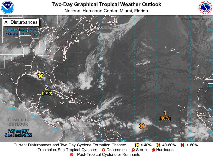
Interests in the Windward Islands should monitor the progress of this system, the NHC said, as the system now has a 70% chance of formation over the next five days.
It has a 40% chance of formation over the next two days.
National Weather Service Director General John Tibbetts and Hazard Management Cayman Islands Director Danielle Coleman appeared on the Cayman Compass Facebook talk show last Wednesday, where they discussed the outlook for the 2022 Atlantic Hurricane season and preparedness.
Meanwhile, NHC forecasters are monitoring an area of disorganized showers and thunderstorms extending from southeastern Louisiana, across the northeastern Gulf of Mexico, and the southern part of the Florida peninsula that is associated with a trough of low pressure.
Development of this system is expected to be slow to occur as it drifts westward across the northern Gulf of Mexico over the next few days.
The system has a 20% chance of formation over the next five days.
For the latest information on storm activity in the Cayman Islands, as well as information on how to prepare for hurricane season, visit the ALT Storm Centre.
Related Videos


