Track Hurricane Ian’s path at the Compass Storm Centre.
The following is the blog of live updates from the Compass as Hurricane Ian approached the Cayman Islands, passed close to Grand Cayman and then headed north toward Cuba and the Florida coast.
All clear issued at 3:30pm
The National Emergency Operations Centre has issued the All Clear for the Cayman Islands, effective 3pm, Monday.
Hurricane Ian is expected to continue on its northwest path, strengthening into a major hurricane by the time it passes over Cuba on Tuesday morning.
The NEOC advised that while weather conditions will gradually improve as the storm moves away from the Cayman area, rough seas, heavy swells, rain and wind are expected to continue for the next 24 hours.
In a statement issued as part of the all-clear announcement, Premier Wayne Panton said, “While we have been very fortunate to have been spared the worst of a potentially very serious storm, I’m extremely pleased to have seen the efforts made by the Caymanian public to prepare for ‘the worst’, while praying for the best. In this situation, this is simply the safest, most strategic thing to do.”
He added, “We are all aware of the considerable anxiety storms can pose for our people. Although the All Clear has now been issued for our islands, we must continue to heed the advisories from HMCI, CINWS and other official sources, to ensure that we keep ourselves and our loved ones safe.”
To facilitate post-storm checks of schools, the Ministry of Education announced that all government schools will remain closed until Wednesday. However, teachers are being asked to report for work at 9.30am Tuesday.
In addition, South Sound Road has been reopened after being cleared of debris caused by the storm.
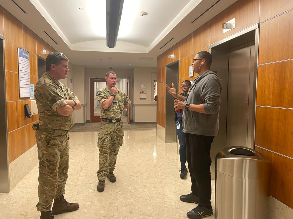
Navy ship arrives
Governor Martyn Roper says HMS Medway is now in Cayman waters, “having arrived here at incredible speed in challenging seas following our call for support”.
He added, “It is reassuring to know how fast the ship can get to us for any future weather events. The ship will be visible off Grand Cayman for the next couple of days. The troops may come ashore later today or tomorrow and assist with relief efforts.”
The governor described Hurricane Ian as a timely test of the Cayman Islands’ readiness and recovery systems.
“We have been given the all clear from Hurricane Ian. Fortunately, the impact across all three Islands has not been as bad as expected, but it is always right to over prepare. It has been a great test of our systems.”
Portions of Seafarers Way closed
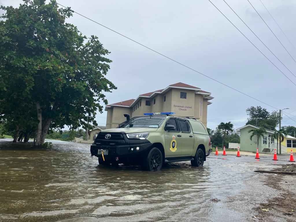
Portions of Seafarers Way in George Town have been closed to motorists as a result of wave activity and debris on the roadway, police have said.
In a press release sent at 3:15pm on Monday, the RCIPS said a section of the road between Goring Avenue and Elmslie Memorial Church had been closed.
Vehicles are being diverted through Goring Avenue.
The Compass team visited this stretch of road earlier this afternoon and found concrete debris in the street.

The road is also closed between Mary Street and Lobster Pot on North Church Street.
Motorists are asked to avoid the area and police are recommending people refrain from being out on the roads until the all clear is given.
The premier indicated earlier this would occur sometime around 3pm.
NRA clearing South Sound Road
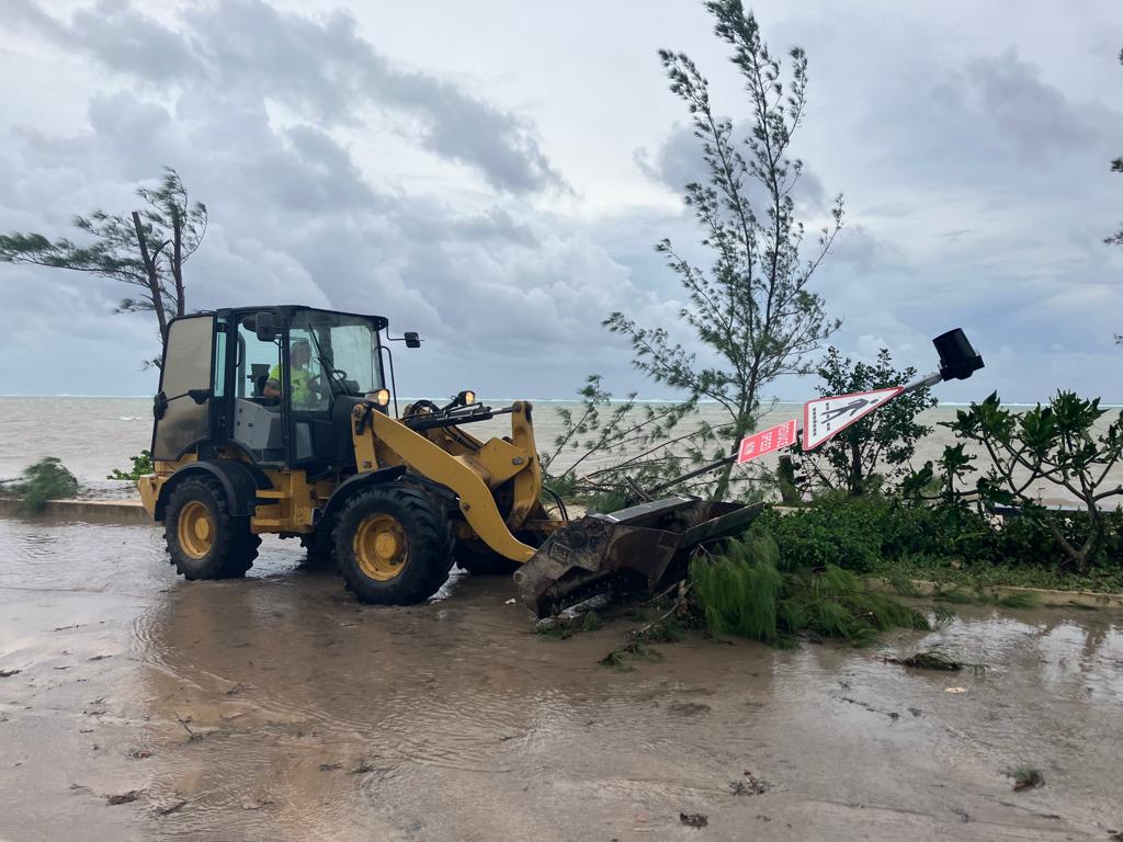
National Roads Authority staff are currently clearing a section of South Sound Road, by Red Bay Dock, that had been inundated with seawater and debris.
The road between Crewe Road and the dock, was closed earlier this morning.
Premier: ‘All clear’ expected after 3pm
Premier Wayne Panton issued an update to Cayman, anticipating the “all clear” will be given after 3pm.
“Remember that the All Clear message lets you know when it is safe for you to move around safely. So STAY OFF the roads under all circumstances, and do not leave your home or shelter until you have heard the all-clear alert!” he said.
Teams from across the National Emergency Operations Centre and government were carrying out assessments he said, in order “to make the All Clear decision”, adding he expected that to come around 3pm.
“I’m extremely pleased to have seen the efforts made by the public to prepare for ‘the worst’, whilst praying for the best. In this situation, this is simply the safest, most strategic thing to do,” he said.
Panton said a tropical storm warning (for Grand Cayman) and watch (for the Sister Islands) remains in place.
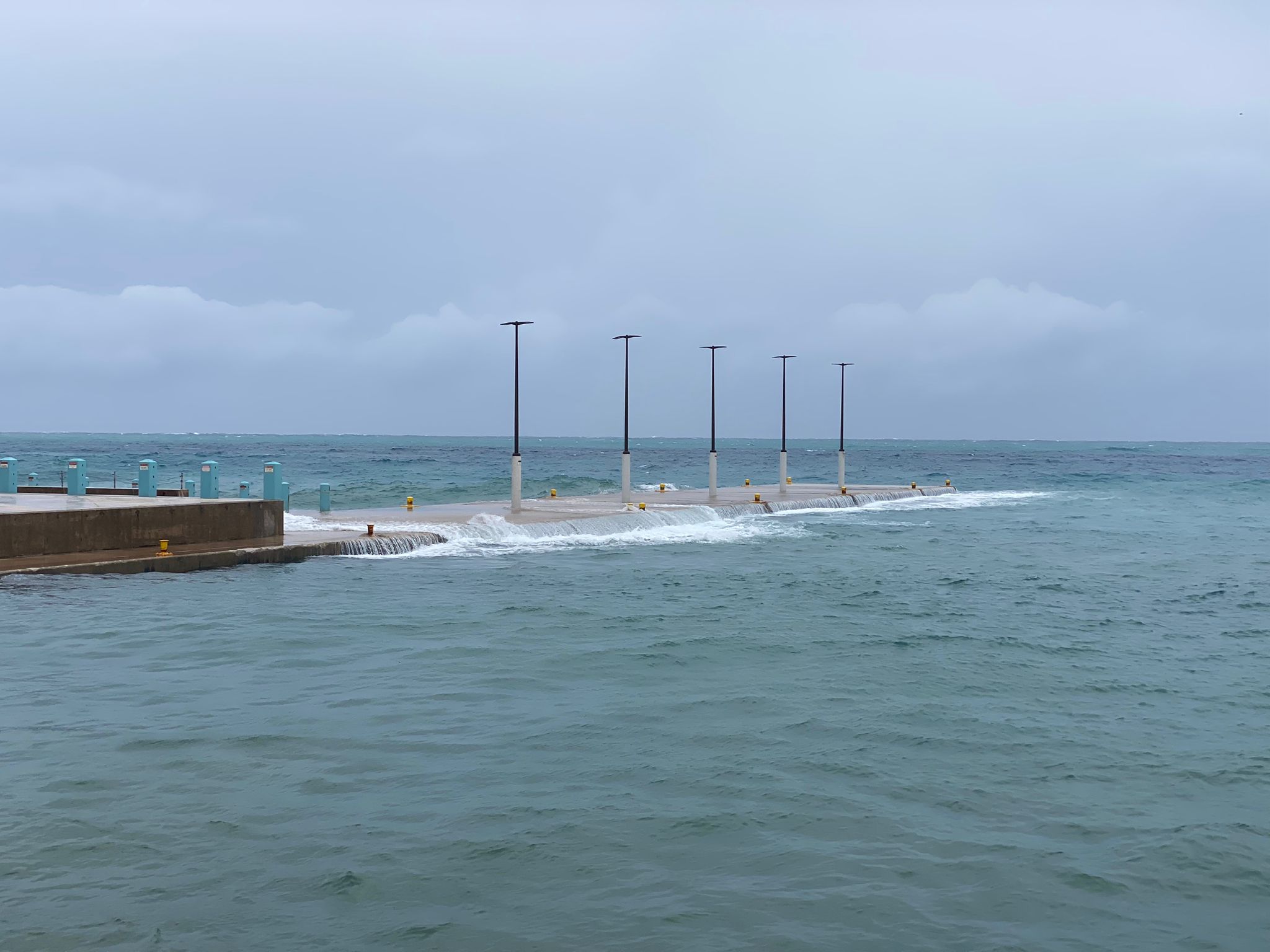
Waves and concrete debris in George Town
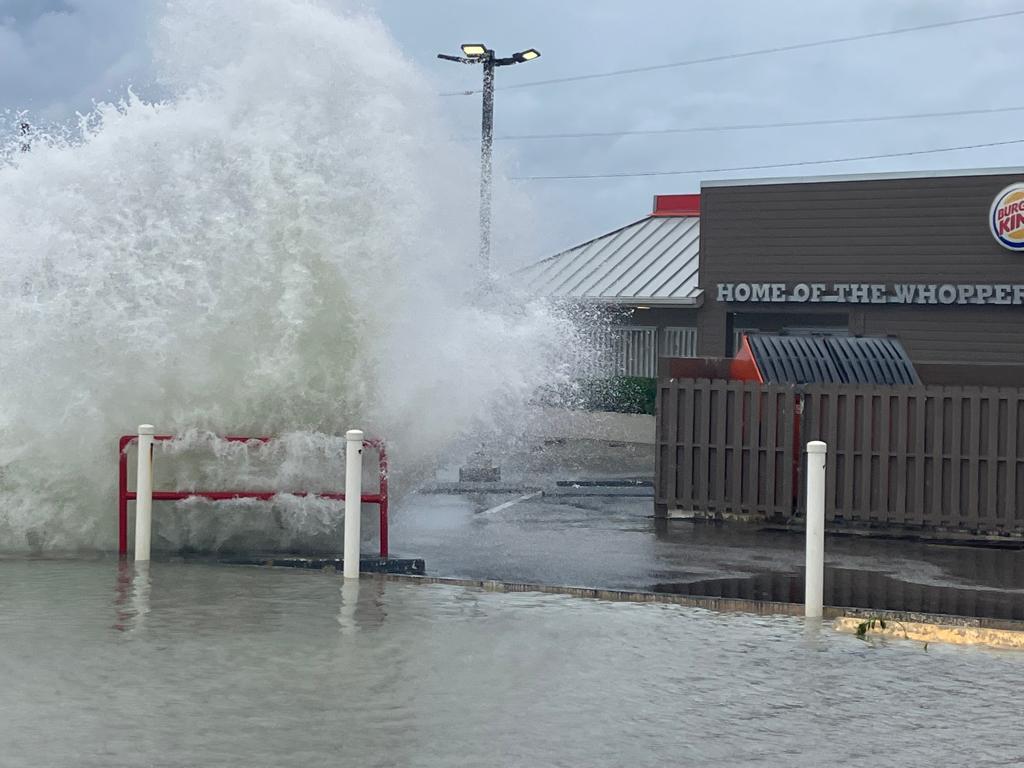
In George Town, Compass editor James Whittaker and photographer Taneos Ramsay encountered waves hitting the Ironshore and splashing as high as the Burger King sign.
The road through town is currently closed as far as the Lobster Pot.
There is some concrete debris in the road, seemingly from a nearby carpark.
‘Minimal debris’ in eastern districts
Lieutenant Tyler Lawson of Cayman’s regiment told the Compass assessments were still ongoing, but there was a “bare minimum of flooding in the eastern districts” because of the way the wind was blowing.
Lawson, who had been operating out of a base at Clifton Hunter, said they had noted flooding in low-lying areas in the eastern parts of Grand Cayman, but there was only “minimal debris”.
In Bodden Town, Lawson said he had not noted any structural damage, nor any power lines downed by the weather. He said there looked like some minor damage to cellular and data infrastructure in the area.
He added that the northern side of the island seemed to have dodged the worse of Ian, noting that the wreaths laid out for the Queen’s memorial were still in place at the monument.
He said his team had not had to evacuate anyone from their homes.
11% of CUC customers currently face outages
Just before 2pm on Monday, 3,804 CUC customers were facing power outages, according to the energy company’s latest ‘outage viewer’.
There were 17 total outages reported at this time.
In an email update sent Monday afternoon, CUC estimated around 11% of its customers were currently affected.
CUC and other utility crews were “beginning to assess the damage to plan for repairs and restoration”.
Customers along from West Bay to George Town, along Seven Mile Beach and into Bodden Town and North Side have been impacted.
Hurricane warning discontinued for Grand Cayman
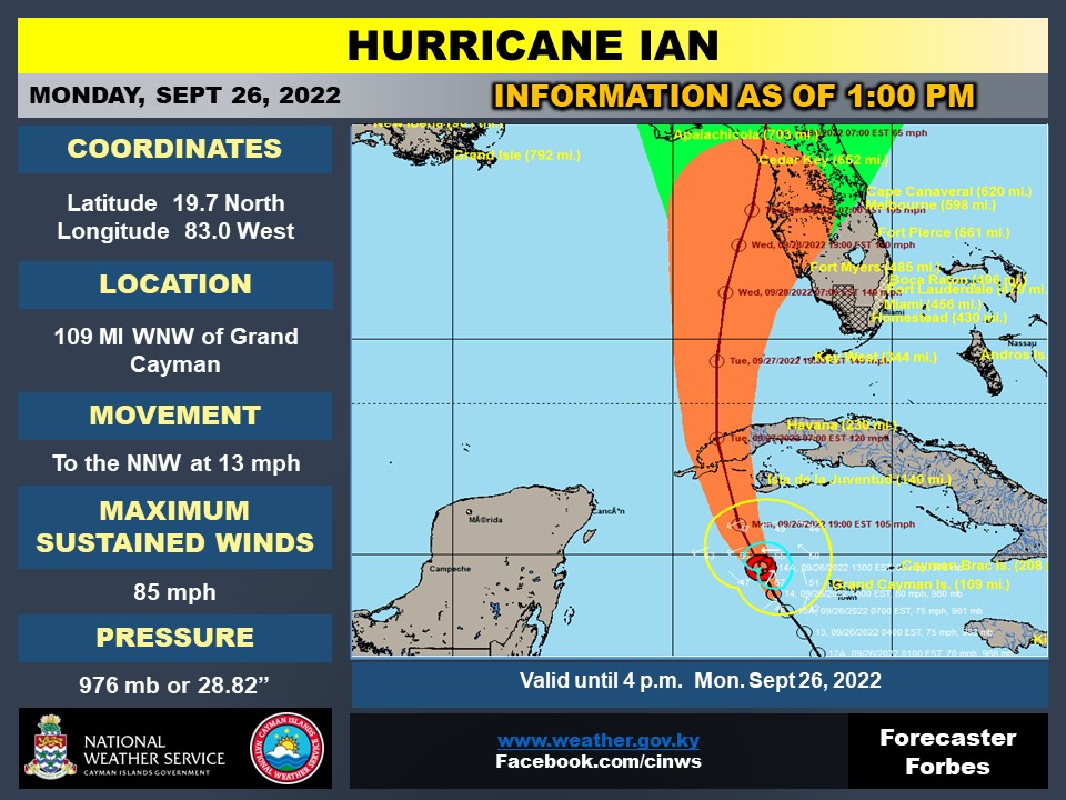
The hurricane warning has been discontinued for Grand Cayman, and replaced with a tropical storm warning.
Meanwhile, the tropical storm watch for the Sister Islands has been discontinued, according to the 1pm update from the National Weather Service, which is warning heavy showers and associated gusts are still anticipated through the afternoon.
At 1pm, the centre of Hurricane Ian was located near 19.7 No and 83.0 W, taking it 109 miles west-northwest of Grand Cayman.
It is moving in that direction at 13mph. Tropical-storm force winds are expected to end around 2pm this afternoon, the latest forecast said.
Hurricane Ian’s maximum sustained winds are now 85mph.
Wave damage across Grand Cayman
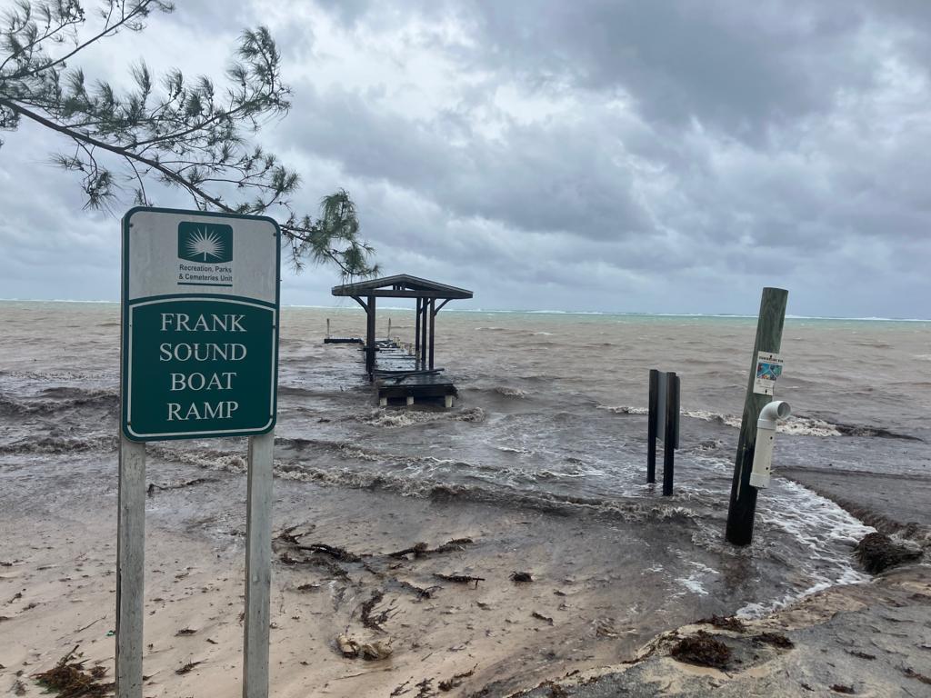
Part of Frank Sound dock is submerged.
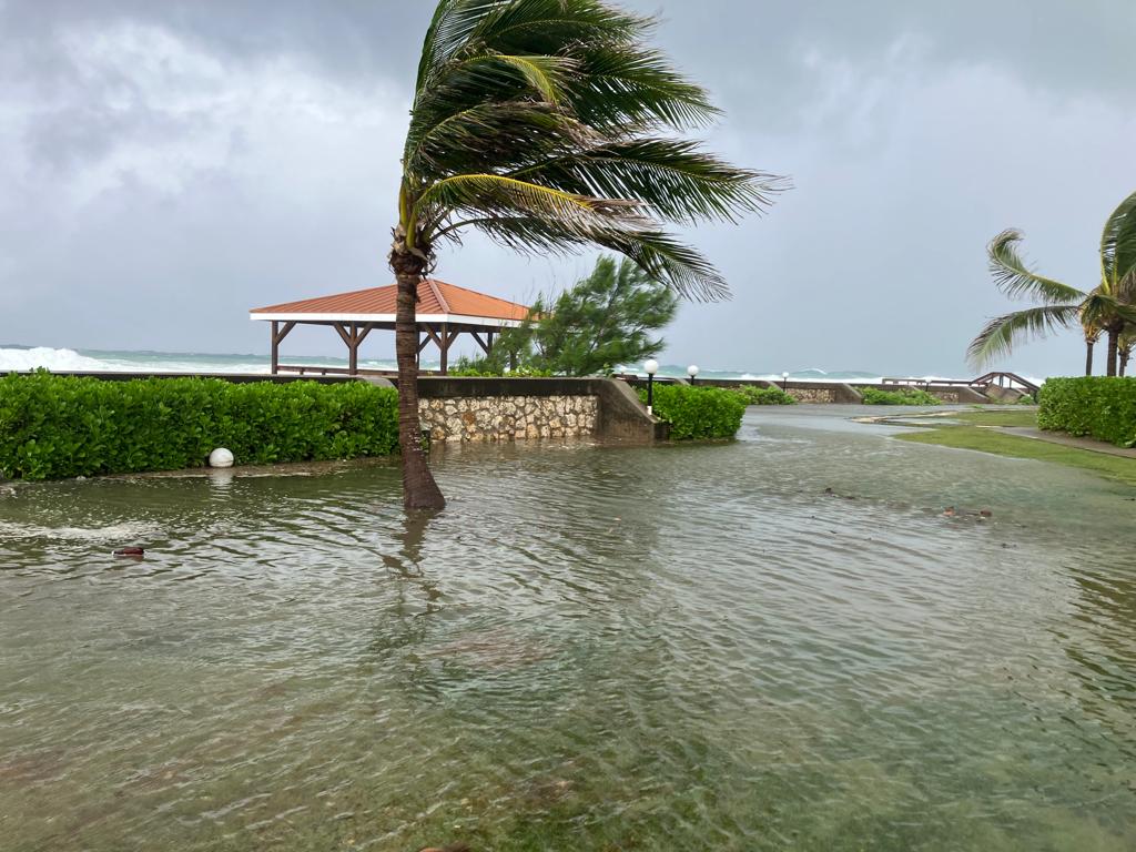
Compass editor James Whittaker and photographer Taneos Ramsay have encountered trees down across the island, with debris in the road and some routes closed from localised flooding, including around the Bodden Town area.
With wave damage and high seas, police are warning residents across the island to stay off the road.
Watch the update from the Compass team on the road here:
CAL fleet ready to resume once airports reopen
Cayman Airways says its fleet is safe and ready to resume services once the airports reopen.
The airline, in a public service bulletin this morning, said its customer service agents are working remotely so that its Reservations Call Centre have resumed regular hours as of noon today.
CAL says Cayman residents and students in Florida seeking to return home to Cayman ahead of Hurricane Ian’s arrival in that state are reminded that they have the option of booking seats on the additional inbound flights to Cayman from Miami and Tampa on Tuesday and Wednesday.
The call centre can be reached on:
Grand Cayman: 345-949-2311
Toll Free in the USA: 800-422-9626
Toll Free in Jamaica: 876-613-9105
Toll Free in Honduras: 800-2791-9422
For the latest flight adjustments this week, which are in addition to the regular flight schedule, click here.
Watch: Hurricane Ian brings high waves, storm surge
Cayman Compass video editor Alvaro Serey has compiled a montage of some of the most dramatic footage from our reporters and readers of the storm so far. High waves and storm surge are submerging docks, bringing down tree branches and flooding coastal condo complexes.
Further impacts could be yet to come as the wind direction shifts and the storm intensifies, even as it moves away from Cayman.
Premier pleads for public to stay inside
Premier Wayne Panton is appealing to members of the public not to become storm sightseers, as the effects of Hurricane Ian continue to be felt across the islands.
As videos taken by people driving on local roads have been appearing on social media while the hurricane warning is still in force, Panton told the Compass in an interview this morning, “We still need people to stay off the roads, and make sure that they stay safe, more than anything.
“It’s not the time to get complacent yet and go out and sightsee. To be honest, that’s when people can get hurt.”
He warned that the squalls that are being experienced across Grand Cayman can still bring down branches and trees and pose a threat to public safety.
CUC: No major outages
Richard Hew, of CUC, said there were no major outages so far, with less than 100 customers losing power as of 10.30am Monday. He cautioned that could change as the wind direction shifts and with the all-clear not expected till mid-afternoon.
Regiment assess damage
Regiment commander Simon Watson told the Cayman Compass that troops had been on patrol already this morning providing support and reassurance to the public. He said they had helped some people evacuate to shelters where necessary. From the preliminary assessment the damage appears to be relatively minor.
He said there had been surge impacts along the coastline, quite a lot of debris in the roads, including fallen branches, but no major structural damage.
Localised flooding, particularly in George Town and Bodden Town, was observed, but nothing that is a potential risk to homes. He warned flood impact could increase as the day goes on and the cumulative effect of the storm adds up.
Tropical-storm winds to dissipate around 2pm
In its latest update, the Cayman Islands National Weather Service reports that Hurricane Ian was about 87 miles west of Grand Cayman, with maximum sustained winds of 80 mph.
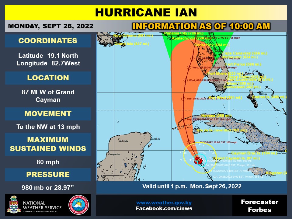
Based on the latest forecast track of the storm, the NWS says tropical-storm-force winds will end by 2pm.
Expected weather conditions for Grand Cayman are overcast skies with widespread thunderstorms through the afternoon as the system passes near Cayman. “Extremely rough seas accompanied by storm surge are also expected,” NWS said. “Swells generated by Ian will spread into the Cayman area later today.”
For the Sister Islands, overcast skies with widespread thunderstorms are expected through the afternoon, with extremely rough seas accompanied by storm surge. On the latest forecast track, the possibility for storm force winds are lower in the Sister Islands than Grand Cayman.
A flood warning remains in effect for the Cayman Islands.
Section of South Sound Road closed
Cayman residents woke up to flooded streets and windswept roads, as Hurricane Ian began to impact the island.
Around 10am, the RCIPS advised that due to flooding and debris on the roadway in the vicinity of the Red Bay Dock, South Sound Road, between Crewe Road and the Red Bay Dock, will be closed to the public at this time.
Motorists will be diverted to through Crewe Road and Walkers Road in George Town. The public is being asked to avoid this area until further notice.

CUC outages as of 8:30am
According to CUC’s outage map, there are currently 87 customers in Grand Cayman affected by power outages.
There are 10 total outages, the CUC viewer stated at 8:30am on Monday morning, as Hurricane Ian was expected to near its closest point to Grand Cayman.
The outages covered customers in West Bay, George Town, Bodden Town and North Side.
CUC stated they were working to “resolve all outages as safely and efficiently as possible”.
Residents strongly urged to stay indoors
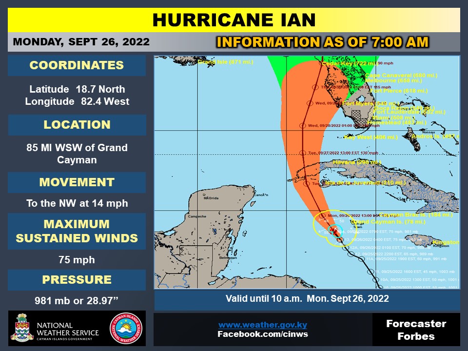
75mph winds as Ian 85 miles WSW of Cayman
Hurricane Ian was located 85 miles west-southwest of Grand Cayman with maximum sustained winds of 75mph, according to the latest update from the National Weather Service.
On the current forecast track, the centre of Ian is expected to pass 75 miles southwest of Grand Cayman on Monday morning with tropical storm force winds expected to end around 3pm this afternoon.
It was located near 18.7 N and 82.4 W. and is moving northwest at near 14 mph.
CUC aware of power outages
There are power outages in some parts of Grand Cayman.
An update from CUC noted that crews would be out to “assess damage and start the restoration process as soon as the all clear is given”.
Bodden Town police station relocates
Bodden Town police station has been relocated to the Bodden Town Primary School.
The move is temporary, during storm conditions, a press release from the Royal Cayman Islands Police said.
“Once storm conditions have passed and it is safe to do so, the Bodden Town Police Station will return to its normal location at 445B Bodden Town Road,” the update added.
The phone number remains 947-2220.
NHC forecasts additional rapid strengthening of Ian
At 7am, Ian is now at the point forecasters believe it will come closest to Grand Cayman.
Video from Lakeside apartments shows steady rainfall and strong winds:
Meanwhile, the National Hurricane Center is warning of “additional rapid strengthening” of the hurricane.
“Ian Will Produce Significant Wind and Storm Surge Impacts in Western Cuba,” a tweet on the NHC’s official page reads.
Hurricane #Ian Advisory 13A: Additional Rapid Strengthening is Expected Today. Ian Will Produce Significant Wind and Storm Surge Impacts in Western Cuba. https://t.co/tW4KeFW0gB
— National Hurricane Center (@NHC_Atlantic) September 26, 2022
Watch: Video as Ian nears its point of closest approach
These are the scenes at the Compass centre on Monday morning. Hurricane Ian is expected to be at its closest point to Grand Cayman within the next hour.
Throughout the night, the wind has both intensified and lessened at times, at points whistling through the trees.
The rain, too, has on occasion come down relentlessly and then stopped for a time. It has weakened to a drizzle at the moment.
130 people in Grand Cayman shelters
Hazard Management’s Communications, Public Awareness and Training Officer Simon Boxall says there are currently close to 130 people in shelters in Grand Cayman and around 30 in the Sister Islands.
Boxall joined National Weather Service Director General John Tibbetts, plus HMCI Director Danielle Coleman, with Reshma Ragoonath for an update as Cayman is impacted by Hurricane Ian.
“From what we’re hearing, people are comfortable. They feel safe and they appreciate that we have these resources available,” Boxall added.
Coleman added that the National Hazard Management Council would be meeting for an update at 6am.
Hurricane force winds ‘do not extend’ to Cayman
Boxall cautioned about the possibility of flooding from waves, with the risk of 2 to 4 foot surge and 5 foot waves possible along the south coast of Grand Cayman.
“There’s a possibility with these big swells being generated, particularly with the intensification occurring, I don’t think we can really let our guard down from the wave threat,” Boxall said.
Tibbetts added that, in terms of tracking Ian, the point of closest approach is expected in the next two to three hours.
He said the hurricane is expected to become a category 2 storm after this point and then a category 3 by Monday evening as it moves north and out of the area.
“The good news is, when the storm is at its closest point, it is at its weakest. It is a category 1 hurricane at that time and the radius of the hurricane force winds is only in the order of 10 to 15 miles. So the hurricane force winds do not extend to the Cayman Islands at all,” he added.
Ian has “behaved itself in significant portions,” Tibbetts said.
While satellite imagery may appear to show a disorganised system, he said there wasn’t a “tremendous deal” of fluctuation from the storm’s forecast path.
Watch the interview here:
Gov.uk emails alert as Cayman impacted by Ian
The UK government issued an email alert at 5:20am Cayman time and updated guidance on its advice page for travel to the Cayman Islands. The update reflected the islands are currently being impacted by Hurricane Ian and remain under a hurricane warning at this point.
Watch: Weather update from the Compass newsroom
Compass journalist Andrel Harris delivers a weather update, following the latest bulletin from the National Weather Service.
It comes as Ian became a hurricane around 4am Monday morning.
The system was located 85 miles south-west of Grand Cayman, according to the CINWS’ update and has maximum sustained winds of 75mph.
Five key messages from the National Hurricane Center
The National Hurricane Center provided five key messages regarding Hurricane Ian in its 5am EST update.
Many of these concerned the storm’s projected impacts on Cuba and Florida, which will experience the hurricane once it has passed through the Cayman area.
The NHC is warning of “life-threatening storm surge and hurricane force winds” on parts of western Cuba by later on Monday. The west coast of Florida and the Panhandle are expected to encounter the same, along with heavy rainfall, by the middle of this week.
Here are the 5 am Monday Key Messages for Hurricane #Ian. Latest information at https://t.co/tW4KeGdBFb pic.twitter.com/536aVhLwl5
— National Hurricane Center (@NHC_Atlantic) September 26, 2022
Watch: Weather outside the Compass at 4:45am:
Wind and rain appears to be intensifying at the Compass centre.
Additional rapid strengthening of the hurricane is expected throughout Monday morning, according to NEOC officials the Compass team has spoken to throughout the small hours of Monday (see below), as Hurricane Ian moves west of us in Grand Cayman.
Ian is then projected to track northwards towards Cuba.
Swells and storm surge forecast as Ian approaches
The National Weather Service 4am bulletin has placed Hurricane Ian’s closest point of approach 75 miles south-west of Cayman by 7am Monday morning, based on the latest forecast track.
By this latest forecast, Cayman is currently experiencing tropical storm force winds, which are not expected to end until 3pm Monday.
Flood and marine warnings remain in effect for the jurisdiction.
Winds of 40 to 45mph, with higher gusts, are forecast throughout Monday morning for Grand Cayman and upwards of 25 to 30mph for the Sister Islands.
The latest forecast estimates wave heights of 11 to 14 feet on Monday, particularly along the south and west coasts.
Swells of 5 to 7 feet are also likely, along with 2 to 4 feet of storm surge.
Hurricane Ian 85 miles south-west of Grand Cayman
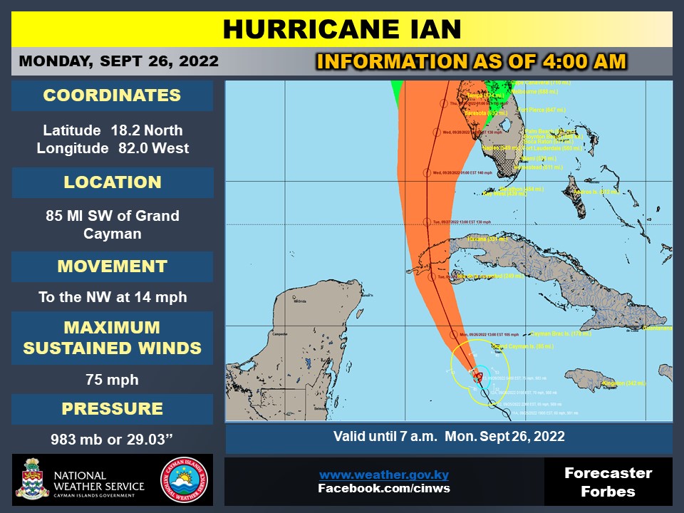
Hurricane Ian is currently located 85 miles south-west of Grand Cayman, according to the 4am update from the National Weather Service.
The storm, which was upgraded to a hurricane shortly before 4am Cayman time, currently has maximum sustained winds of 75mph.
Hurricane Ian was located at 18.2N and 82.0W at the time of this most recent update and is moving towards the north-west at 14 mph with minimum central pressure of 983mb / 29.03 inches.
Tropical Storm Ian becomes Hurricane Ian
The National Hurricane Center has advised that Tropical Storm Ian has now become Hurricane Ian.
The weather system remains to the south west of the Cayman Islands.
On its official Twitter page, the NHC warned of “additional rapid strengthening” and forecast “significant wind and storm surge impacts in western Cuba”.
Hurricane #Ian Advisory 13: Ian Becomes a Hurricane and Additional Rapid Strengthening Is Expected Today. Expected to Produce Significant Wind and Storm Surge Impacts In Western Cuba. https://t.co/tW4KeFW0gB
— National Hurricane Center (@NHC_Atlantic) September 26, 2022
‘We’ve been in bigger cities, darker nights’
Community psychiatric nurse Dympna Carten joined Compass Media earlier in the evening to discuss issues surrounding the mental health implications of Tropical Storm Ian.
The mental health helpline is open throughout the duration of the storm: +1 800 534 6463.
The helpline was started during the COVID-19 pandemic.
“What we’ve been very good at doing in NEOC and the Hazard Management team is acknowledging that we need to put measures in place, that we need to be more mindful of the community’s needs, individual needs and people who may be at risk and who are vulnerable,” she said.
Emphasising that it’s normal to feel a little anxious and overwhelmed at times like this, Carten advised, “We will get through this. We’ve got to take things one step at a time, we must remain positive and we must always seek support.”
She offered some practical tips for managing stress, such as calling the mental health helpline, taking “big, big, big, deep, slow breaths” and “tell yourself that ‘this too shall pass’ and ‘we will get through this.’ It’s really important that we remain positive”.
She advised people to remind themselves of “strategies and support mechanisms” they’ve used to manage in the past.
“We are in a very resilient place here; we are with a very resilient bunch of people,” she said and praised the “cohesive community” found in Cayman.
“We’ve been in bigger cities, in darker nights and I don’t think tonight is going to be our darkest night,” she concluded.
Listen to that full interview here:
Watch: Outer rain bands of Tropical Storm Ian
Hazard Management Cayman Islands posted a video update to its Facebook page, showing the outer rain bands of Tropical Storm Ian, outside the Government Administration Building early on Monday morning.
Red Bay and other low-lying coastal areas a potential concern
Hazard Management’s Communications, Public Awareness and Training Officer Simon Boxall joined the Compass Media team of Doug Dodds and Mark Lee on Gold in the last half an hour, as Cayman starts to experience the outer rain bands from Tropical Storm Ian.
The system is starting to “power up,” Boxall explained, as had been anticipated.
He said, although we may be sufficiently far away to avoid the hurricane force winds, Cayman should still brace for “heavy rain, flooded roads, very difficult driving conditions”.
“The waves are possibly going to be a concern,” Boxall warned.
He emphasised that particularly vulnerable to Ian were “low-lying coastal areas along the south coast, in particular parts of the Red Bay stretch” where we’ve seen waves breach the coastline in the past.
As the system approaches, “you’ll start to see the south coast get impacted by pretty heavy swells and waves, possibly a little storm surge,” Boxall said.
He said there was a chance we could see seas of up to 14 foot later on Monday.
HMCI: Conditions will deteriorate

Boxall said conditions are expected to deteriorate and tropical storm force winds will begin in the next few hours.
The situation in terms of emergency services, was “fairly calm” according to Boxall, although one person has been transported to Health City.
The situation on the roads remains clear, he added.
“At this stage, it’s still a bit of a watch and wait game,” Boxall explained.
Listen to the full interview here:
Ian looks ‘more organised’
Cayman Islands National Weather Service Director General John Tibbetts told Doug Dodds and Reshma Ragoonath from the Compass Media team in the last hour that Tropical Storm Ian was starting to look “a bit more organised”.
“We’re now going to go through for… an hour, two hours perhaps of heavy, torrential downpours with some stronger wind gusts,” he said.

“We are on the edge of some of the heaviest showers that we’re going to get with this thing,” Tibbetts added.
He forecast wind gusts of 30 to 40mph.
He added that Cayman could expect to see the worst of the seas later on Monday, around 10 to 12 feet, as the system nears the jurisdiction at 7am. He also warned of 2 to 4 feet of storm surge.
In comparison to Tropical Storm Grace last year, Tibbetts stated he didn’t see the same “level of rapid intensification” with Ian.
“When you look at Grace, we had a peak tropical storm force system going through the Cayman Islands and yet we had wind gusts up to Cat. 2. You usually don’t have that wide a variation in the wind gusts,” he said.
He predicted 1 to 2 inches of rain, but cautioned this could go up to 5 inches, if a thunderstorm was to linger over Cayman for an extended period of time.
Listen to the full interview here:
Winds of 70mph, as Ian now 111 miles SSW of GCM
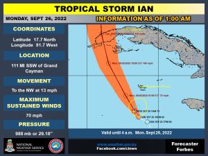
Tropical Storm Ian is now 111 miles south-southwest of Grand Cayman. Maximum sustained winds have increased to 70mph.
As of the update from the National Weather Service at 1am on Monday morning, Ian is moving northwest at near 13 mph.
On the forecast track, the centre of Ian is expected to pass 73 miles southwest of Grand Cayman around 7 am.
At the time of the update, the centre of Tropical Storm Ian was located near 17.7 N and 81.7 W.
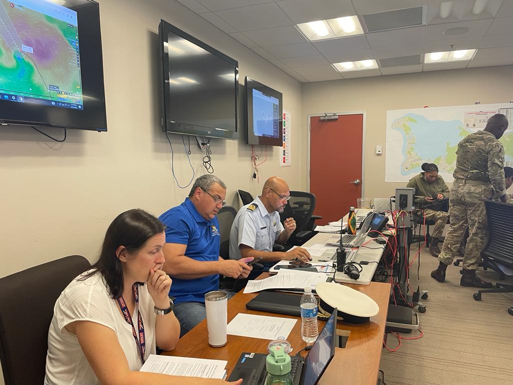
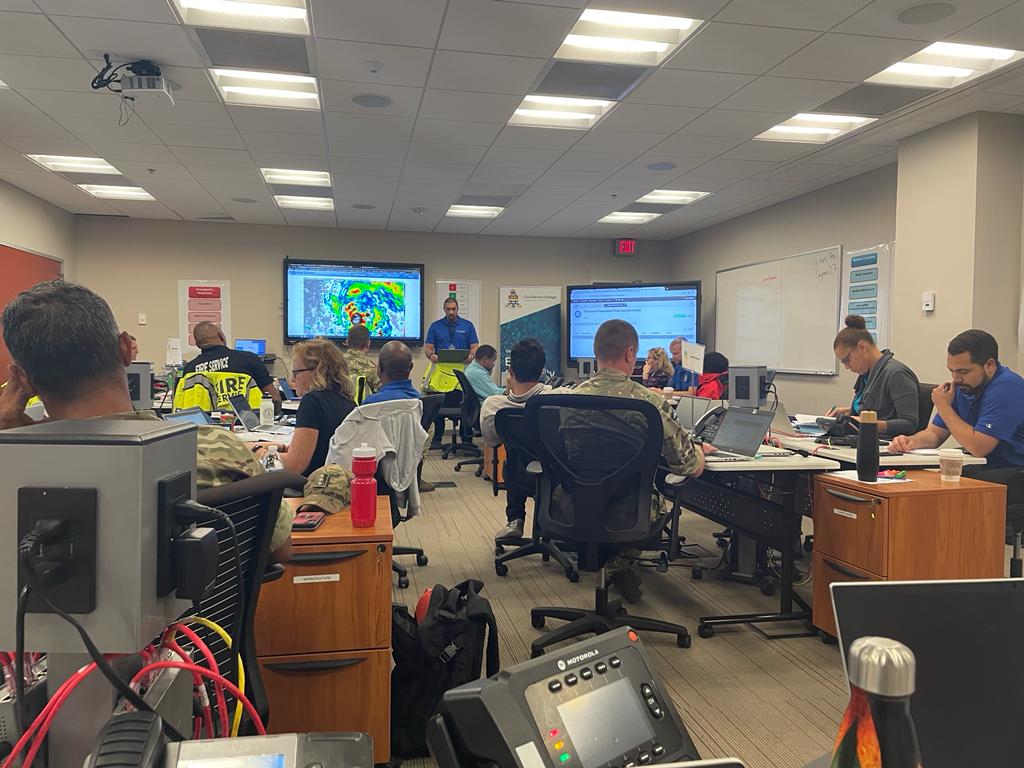
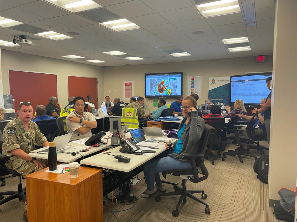
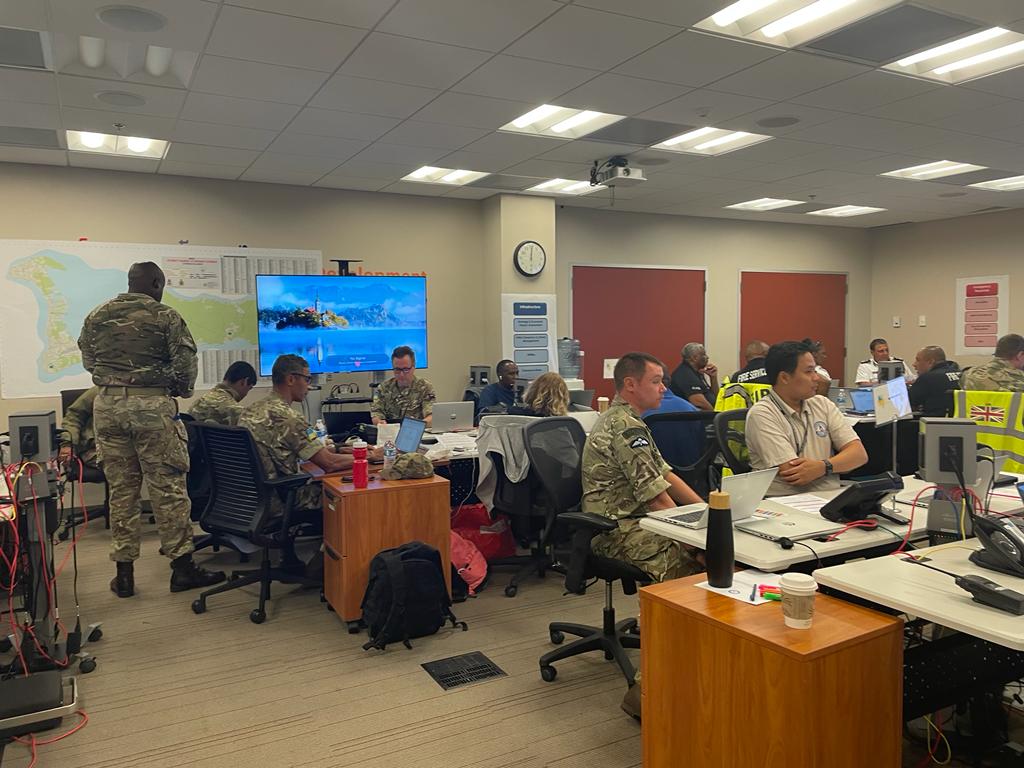
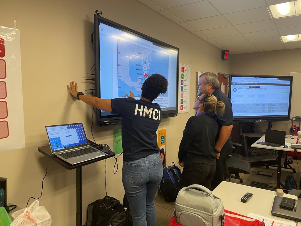
Watch: Inside the NEOC
Want to see inside Cayman’s National Emergency Operations Centre?
Commander Robert Scotland of the Cayman Islands Coast Guard (in the role of NEOC Manager) takes situational updates from the four cluster leaders in the NEOC.
Photos: Inside the NEOC
Earlier, Premier Wayne Panton told the Compass Media team there was a “lot of activity” going on at the NEOC. Deputy Governor Franz Manderson, who is chair of the NEOC, described the clusters that make up Cayman’s emergency operations hub as a “battle-hardened team”.
Click below to see the NEOC in operation just moments ago.
Water Authority: No planned interruptions
There are “no plans at this time to interrupt water service,” according to the Water Authority.
This is based on the “current predictions of the path of the storm,” the agency said. Should that change, a post on their Facebook page said, “the Authority will give as much notice as possible”.
Premier: Cayman’s storm operations ‘one of the best’
Premier Wayne Panton, in position at the National Emergency Operations Centre, said there is a “lot of activity” at the headquarters of Cayman’s preparedness and response efforts.

“I think the operation here is… probably one of the best operations throughout any of the Overseas Territories and perhaps even many of the larger countries,” Panton stated, speaking to Compass Media’s Doug Dodds on Z99 and Gold FM.
The agencies are all represented and working together, the premier explained, with the call centre next door, ensuring “proactive” and “reactive” work was being done.
The top issue, he said, from his perspective was safety, followed by making people feel “a sense of calm, assurance that they’re not going to have to worry about someone responding… and addressing their needs”.
“Government was nowhere near organised, the way they are today,” he said, when asked about lessons learned since Ivan.
Listen to the full interview between Premier Wayne Panton and Compass Media’s Doug Dodds here:
Premier: ‘This is not Grace’
The latest weather briefing, Panton said, suggested we will see tropical storm force winds of around “40 to 50mph” in the early hours of Monday.
The premier explained later in the day, the wind may worsen, before it improves.
“This is not a Grace type of event,” he said.
“We are not expecting at all the same kind of winds we had during Grace last year. I don’t want people to worry and be concerned about that. They should remain calm. We will get through this,” he said.
“The country is in very safe hands. I have no worries. I don’t think anybody else should,” Panton told Dodds.
Governor and Deputy Governor in touch on ‘hourly’ basis
The Deputy Governor and Governor are in “hourly” contact, Chair of the National Emergency Operations Centre Franz Manderson told Compass Media’s Doug Dodds live on the radio.

Governor Martyn Roper has worked “exceptionally hard,” Manderson said to ensure the UK “knows what’s happening in Cayman” as he noted the advanced team from the UK’s Ministry of Defence here with us already and the presence of a Royal Navy ship in the vicinity to assist once the storm has passed.
He also noted Cayman had an important resource, “an extra pair of hands,” in the regiment, to assist police, the fire service and NEOC.
The regiment are professional, committed and focused, he said.
A ‘battle-hardened team’
“We have grown leaps and bounds since Ivan,” Manderson said.
Reflecting on changes since then, when there was a hurricane committee of “a few volunteers,” Manderson noted Cayman now has Hazard Management Cayman Islands and the Doppler radar, among other developments.
“We’re not just focused on preparedness, we’re also focused on the aftermath, how are we going to get out and rescue persons, clean up the roads, repair our infrastructure, get the country back up and running,” he said.
He explained comprehensive planning, running scenarios and table-top exercises has meant Cayman has a “battle-hardened team that knows exactly what they’re doing and everyone is standing by now to react after the storm has passed”.
DG: Ian will strengthen ‘very quickly’
Manderson joined Compass Media, ahead of an expected deterioration in weather conditions for Grand Cayman over the next few hours.
“People should be home snug in their beds and prepared, keeping watch and keeping tuned in to official channels” he told listeners on Z99 and Gold FM.
This storm is “unpredictable,” Manderson warned, adding “It has not been behaving as we would normally expect a weather system to behave… there is a 100% chance it’s going to strengthen and strengthen very quickly.”
Listen to the interview below:
CINWS: Tropical storm conditions by early Monday
The latest weather bulletin forecasts that, if Ian continues on its current track, overcast skies with widespread thunderstorms will become tropical storm conditions by early Monday.
Extremely rough seas accompanied by storm surge are also expected.
Gusts of 20 to 30mph are expected on Grand Cayman on Sunday evening and 15 to 20mph with higher gusts on the Sister Islands. This is expected to increase to 40 to 45 mph, with higher gusts, on Monday morning for Grand Cayman and upwards of 25 to 30 mph for the Sister Islands.
Flood and marine warnings are in effect for Cayman.
The latest forecast estimates wave heights of 6 to 8 feet, especially along the south coast for Sunday and 11 to 14 feet on Monday, particularly along the south and west coasts.
Maximum sustained winds now 65mph
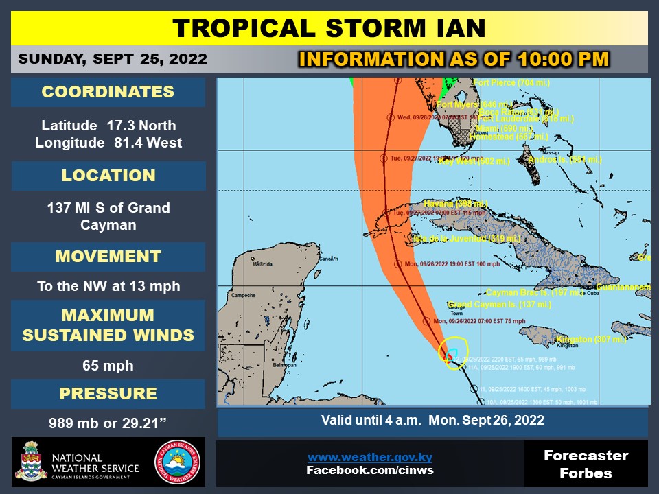
Tropical Storm Ian is now 137 miles south of Grand Cayman, with maximum sustained winds of 65mph.
The latest severe weather bulletin from the National Weather Service also updates the closest point of approach of the storm to 73 miles south west of Grand Cayman.
At 10pm, Ian is moving towards the north west at 13mph. The onset of tropical storm force winds is projected for 4am and expected to end at 3pm.
Shelters are open
Six shelters are open for those in need on Grand Cayman and one on each of the Sister Islands.
These include: West Bay Primary, John Gray High School, Bodden Town Primary, Clifton Hunter High School, East End Civic Centre, the Red Cross, the Aston Rutty Centre in Cayman Brac and the Public Works Department Building in Little Cayman.
Seek shelter if in area prone to flooding
Low-lying areas in Grand Cayman are expected to experience flooding, according to the latest severe weather bulletin from the Cayman Islands government.
4 to 5 foot seas are forecast to impact the south coast of Grand Cayman from Sunday evening, along with a 2 to 4 foot storm surge.
As a result, residents who live long the south coastline in areas known to be “prone to coastal impacts during hurricane events may wish to use the next few hours to seek safe shelter as a precaution,” the update advised.
These areas include: South Sound, some parts of the coastline from the Hurley’s Roundabout to Spotts, Red Bay and Old Prospect areas.
CAL fleet relocated for safety
Our of “an abundance of caution,” Cayman Airways has relocated several of its aircraft in preparation for Tropical Storm Ian.

According to a press release, the airline made the decision to ensure the aircrafts’ safety and to “ensure business continuity after the storm”.
The Cayman Airways Express fleet, along with a B737-8 jet, are stationed at the Charles Kirkconnell International Airport on the Brac.
Three of the airlines other B737-8 planes will remain at New York’s JFK, Miami and Tampa respectively.
Low water pressure warning
Water Authority is advising customers may temporarily experience low water pressure as they switch to a backup power.
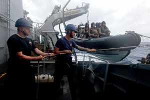
Photo: HMS Medway en route to Brac
The Commander of HMS Medway told Governor Martyn Roper they anticipate the ship will arrive in Cayman Brac as the storm passes. Medway’s troops – seen in this image posted on the governor’s Facebook page – will come ashore to support with the relief effort in the aftermath of the storm.
Watch: Update from Hazard Management and National Weather Service
Watch the Compass’ latest update with journalists Reshma Ragoonath and Andrel Harris, who were joined by Hazard Management Director Danielle Coleman and National Weather Service Director General John Tibbetts:
How does the NEOC work?
Coleman tells the Compass more about how the National Emergency Operations Centre works. The NEOC has been operational since 4pm on Sunday afternoon.
It’s made up of “clusters” including: an operations cluster, human concerns, support services, infrastructure and emergency response, she said.
There are 18 functioning emergency support teams, with specialities including debris clearance, evacuation, shelter operations, mental health and joint communications service.
20-30 people are in shelters
Coleman says people are already being transported to shelters and calls are beginning to come in to the NEOC.
“We expect an increase [in calls] throughout the evening,” she said.
20-30 people, she said, are already in situ in Cayman’s shelters, particularly in George Town and East End.
345 949 6555 is the number to contact the centre, which will remain open throughout the night, along with the mental health helpline at 1 800 534 6463.
Weather Service Director General: Ian will become a hurricane by Monday
National Weather Service Director General John Tibbetts told the Compass that Ian is “not particularly organised” which means weather forecasts are constantly updating.
National Hurricane Center forecasters expect it to become better organised and will strengthen into a hurricane by Monday.
“Just about all of Grand Cayman will be impacted by tropical storm force winds,” he warned, according to the latest data.
He added those winds will last from around 6am to 3pm on Monday, accompanied by heavy showers and rough seas.
Ian is 160 miles south of Cayman
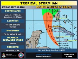
The latest update from the National Weather Service as of 7pm shows Tropical Storm Ian closer to Grand Cayman, with maximum sustained winds of 60mph.
Ian is now 160 miles south of Grand Cayman.
The ‘intermediate update’ does not include a change in forecast track or expected conditions.
The tropical storm is moving northwest at 12 mph and the system now has maximum sustained winds of 60mph with minimum central pressure of 991mb.
Grand Cayman residents advised to stay off roads
The NEOC is encouraging residents in Grand Cayman to avoid driving on the roads beginning 8pm tonight.
Heavy bands of rain are forecast to begin affecting Grand Cayman, resulting in deteriorating road safety conditions.
Governor: ‘We can’t afford to be complacent’
In an update on his Facebook page, Governor Martyn Roper warns that the latest forecast shows Tropical Storm Ian shifting slightly east toward us.
He warned the islands to “prepare for the worst”.
“We can’t afford to be complacent. The impact from Storm Grace last year is a reminder of what could be in store,” he said.
Roper said he had spoken to the Commander of the Royal Navy ship HMS Medway and the ship is expected to arrive in Cayman Brac as the storm passes where it will shelter before heading on to Grand Cayman.
“Medway’s personnel troops will come ashore to support with the relief effort in the aftermath of the storm and once safe to do so,” Roper said.
Useful numbers:
- The National Emergency Operations Centre call line is now open and will remain open while the NEOC is activated: 345 949 6555.
- In an emergency please call 911.
- Mental Health Helpline: 1 800 534 6463.
Compass journalists Stephanie Ditta, Andrel Harris, Caroline James and Reshma Ragoonath contributed to this story.
Related Videos


