Invest 96L strengthened to Tropical
Depression 18 to Tropical Storm Rina to Hurricane Rina in just 21 hours and is
now forecast to become a major Category 3 hurricane in the northwestern
Caribbean Sea.
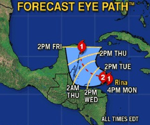
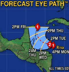
As of Monday afternoon, Rina was about 193
miles southwest of Grand Cayman and moving northwest at 5mph. With the
distance between Rina and Grand Cayman increasing, the storm isn’t expected to
have a significant impact on the Cayman Islands if it continues along its
forecast track.
However rainy conditions will continue on
Grand Cayman until Wednesday, said Cayman Islands National Weather Service
Meteorologist Avalon Porter.
“After that there should be some clearing
for a day or so, then we expect more weather to move in,” he said.
Rina brought nearly 3 inches of rain to
Grand Cayman over the weekend and another inch to an inch and a half of rain
was expected before Wednesday.
Although seas remained moderately rough and
a small-craft advisory is in effect through Tuesday night, the worst effect of
Rina on Grand Cayman was some localised flooding of low-lying areas.
Mr. Porter said the winds were only forecast
to be 10 to 15 knots out of the east-northeast.
“There could be higher gusts in the
showers,” he said.
Homes and businesses in North Side and East
End were without power for more than two hours Monday morning, possibly caused
by the rain and winds from Rina.
The official National Hurricane Center in
Miami track forecasts Rina to make landfall as a hurricane on Mexico’s Yucatan
Peninsula near Cozumel on Friday morning, and then head northeast toward the
western tip of Cuba.
Related Videos


