
Sustainable Cayman has published a report comparing the government’s East-West Arterial extension with two alternatives – one of which it says is a cheaper and greener option.
The 14-page document examines the National Roads Authority’s proposed 16-kilometre multi-lane highway road set to run from Hirst Road to Frank Sound Road.
It also looks at two other routes – both of which avoid the Central Mangrove Wetland – and details their social impact, accessibility, environmental impact, climate resilience, and cost.
A Sustainable Cayman spokesperson told the Compass the report aimed to “justify the most sustainable options, taking into account present concerns and the direct needs of the local communities”.
The non-profit seeks to promote environmental sustainability and conservation of Cayman’s natural assets, according to its website.
The ‘Route corridor optioneering report 2023’, produced with the UK’s Royal Society for the Protection of Birds (RSPB), concludes that one of its own suggested options is the most environmentally friendly and cost effective.
Central Highway
The report begins by discussing the NRA’s East-West Arterial road extension.
It says the project, dubbed the ‘Central Highway’, was first discussed in 2004 after Hurricane Ivan damaged existing coastal roads, cutting off parts of Grand Cayman.
This led to plans being drawn up to address the issues caused by Ivan, as well to keep an eye on climate-change resilience and improved emergency vehicle access, the report says.
The road, which was first gazetted in 2005, was designed to improve traffic flow between the east and west of Grand Cayman, particularly at peak times.
The NRA’s proposed road extension would traverse a substantial area of the entire length of the southern perimeter of the Central Mangrove Wetland, the independent report says.
“It is estimated that a minimum of 124 acres would be directly cleared and deforested,” it adds.
The NRA has commissioned a consultancy firm to produce an environmental impact assessment and is privately assessing route options, the report explains.
Alternative roads
Sustainable Cayman’s report contains a diagram with three technically viable route alignments.
The NRA proposed route is the current one being publicly shared.
Route 2 is an alternative route option proposed by the RSPB with the aim to avoid as much high value habitat as possible.
Route 3 is another alternative alignment which would involve upgrading current roads as well as constructing new sections where required.
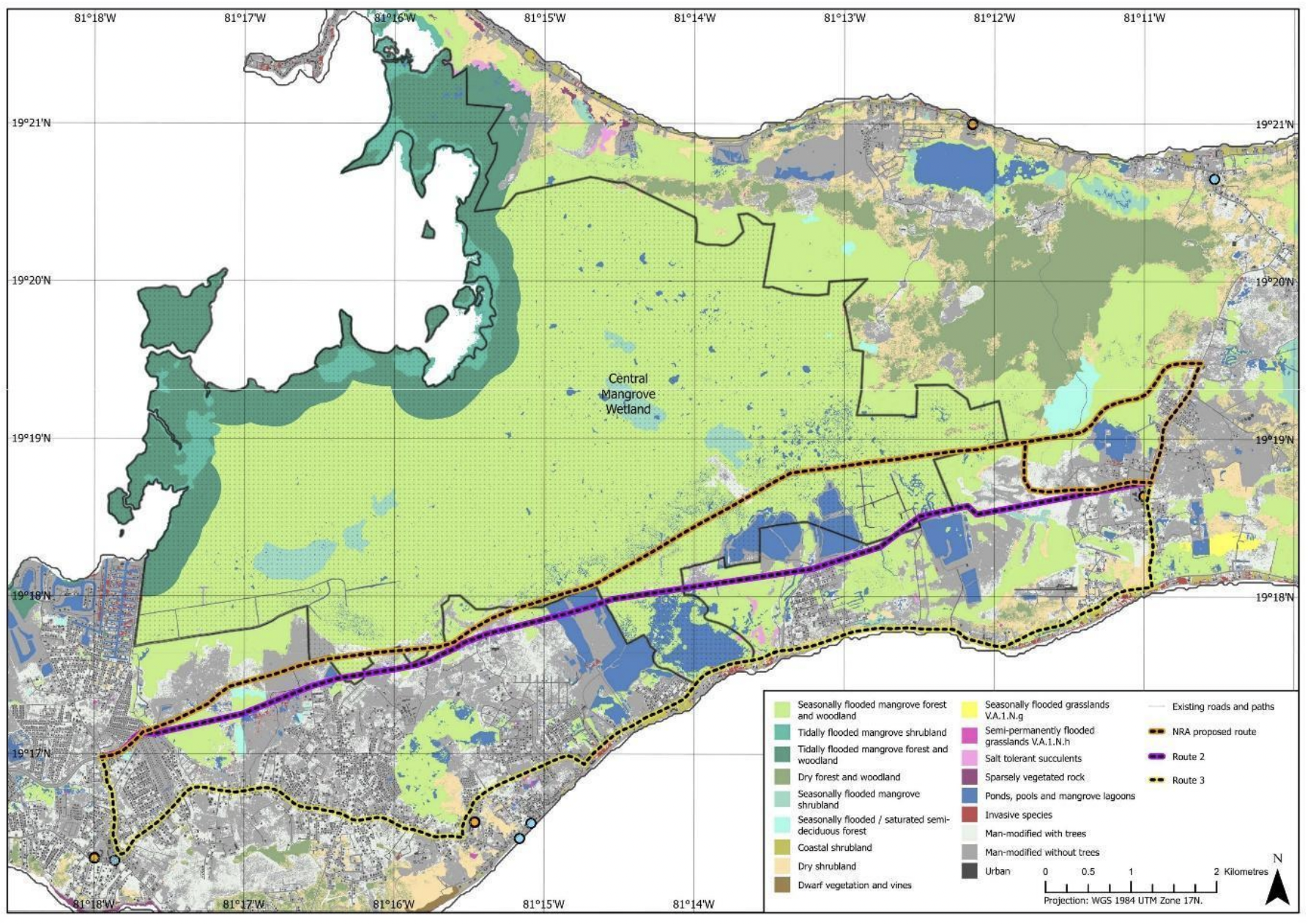
The report examines the social impact and accessibility, environmental impact, climate resilience, and potential cost of building each road.
It determined that no route would fully solve the existing bottleneck problem at the intersection of Hurley’s roundabout.
However, it argues that the 14-kilometre Route 2 would improve traffic flow, connect schools and residential areas, and reduce the travel time for the average commuter.
“Connector roads from the coastal road by Midland Acres to Route 2… would provide relief from traffic from the east onto the bypass,” the report says.
It adds: “All traffic from the north would join along the Frank Sound Road connector thus easing the commute for all Eastern districts as well as the bottleneck in Bodden Town.”
The Route 2 option would also have the least negative impact on the environment and the community, the report says, because it does not cut through the Central Mangrove Wetland nor damage the Mastic Trail.
“A route that has less direct impact on habitat means that it will affect fewer species and ecosystems, and preserve more natural resources,” the report says.
The route comes in at an estimated $61.90 million – based calculations made following a freedom of information request which gave 2015 budgeted costs for materials and labour.
The expected cost of route 3 is $41.3 million, though it is likely that number will go higher due to the need to build it around existing infrastructure, the report says.
Meanwhile, the NRA proposed route fails on a number of climate resilience criteria as well as providing limited accessibility and higher predicted cost at $70 million, according to the report.
Holistic approach
Natalie Hall of the RSPB, in a press release from Sustainable Cayman, said she believes infrastructure development should not come at the cost of environmental degradation.
“That is why we should always conduct rigorous environmental impact assessments before initiating any project.”
She suggested also adopting a holistic approach to development, which considers both human and natural systems, and the long-term sustainability of interventions.
“By doing so, we aim to create infrastructure that is not only functional and efficient, but also harmonious and resilient,” Hall said.
“The traffic issues currently faced by Caymanians cannot be solved by a new road in isolation.”
The report invites the public to review it, provide feedback and to engage in discussion with their member of Parliament.
Related Videos


