
The Ministry of Planning, Lands, Agriculture, Housing and Infrastructure and the National Roads Authority (NRA) are standing by government’s decision to extend the East–West Arterial along the route identified as ‘B3’ on the shortlist of possible paths.
Their defence comes in response to objections from the National Conservation Council, which has urged Cabinet to reconsider and instead select the alternative route known as ‘B2’.
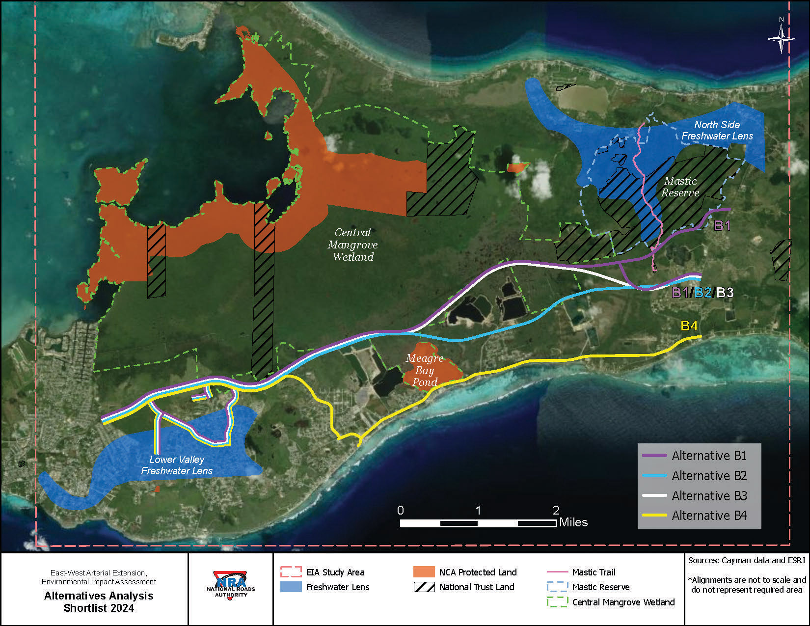
The East-West Arterial (EWA) extension – an eight-mile road extension from Woodland Drive to Frank Sound Road – originally considered four routes (B1, B2, B3 and B4) before the choice was narrowed to B2 and B3. In 2024, under the previous government administration, Cabinet selected route B3, which the ministry said offered the best balance between “infrastructure development and environmental stewardship.”
In a joint statement to the Compass, the ministry and National Roads Authority responded to concerns raised in an 8 Aug. letter from the National Conservation Council.
The letter, signed by NCC Chair Ian Kirkham, included the Environmental Assessment Board’s final report on the project’s Environmental Impact Assessment, which highlighted three major concerns – overall costs, the scale of environmental impact and the limited long-term traffic relief expected. The report further argued that the alternative route B2 would be more cost-effective and less damaging to the environment.
At its 17 Sept. general meeting, the National Conservation Council confirmed the letter and report were sent to Environment Minister Katherine Ebanks-Wilks, along with a summary for Cabinet.
In response to a Compass query, Ebanks-Wilks noted that reversing a prior Cabinet decision is a serious step and said the issue would need to go to caucus.
The traffic relief question
When Cabinet originally announced in August 2024 that it had chosen route B3 for the East–West Arterial extension, officials presented the decision as a long-term answer to Grand Cayman’s growing congestion. The Ministry of Planning said B3, though only half a kilometre longer than B2, aligned more closely with Cayman’s long-term infrastructure vision and offered better construction conditions.
The National Conservation Council challenged those claims, saying the Environmental Impact Assessment (EIA) does not support the idea that the road will meaningfully solve Cayman’s traffic problem in the long term. The EIA projected only small time savings – five to seven minutes between now and 2046 – despite the road’s multi-lane design.
“The road is not a panacea for the island’s traffic problems,” said Environmental Advisory Board Chair and Department of Environment Director Gina Ebanks-Petrie at the National Conservation Council meeting. “That is very clear from the assessment that was done on the NRA’s own traffic data.”
The National Conservation Council concluded that the road’s main benefit would be to prevent traffic from getting worse under Cayman’s current rapid population growth trajectory. Even then, the road would only be adequate under a medium-growth scenario of about 135,000 people by 2074. At higher growth levels, congestion would quickly return.
“This underscores the urgent need for the government to develop other measures, including a fit-for-purpose public transportation system,” the National Conservation Council wrote in its letter.
However, the ministry and NRA challenged the National Conservation Council’s interpretation of the Environmental Impact Assessment, stating that it was not aligned with the purpose of the study, which was “to evaluate environmental implications rather than provide a comprehensive transport demand forecast.”
They added that the EIA traffic analysis had assumed static vehicle-growth rates through 2074, without factoring in future transport innovations such as public transit or micro-mobility. As a result, they said, it underestimates the long-term benefits of a more balanced, multimodal transport network.
“It is estimated that without the EWA, Caymanians could collectively lose approximately 18.5 million hours annually due to traffic congestion, resulting in substantial productivity losses and economic inefficiencies,” the joint statement read.
The ministry and NRA also noted that route B2 would disrupt the main yard of a major quarry, while route B3, farther north, offers greater long-term potential for housing expansion and decentralising jobs through new commercial and industrial development.
The ministry and NRA added that the extension would eliminate the island’s chronic one- and two-hour traffic jams, enhance safety by separating different road users and provide an inland corridor that would keep the island connected during coastal flooding events. They said the route would boost productivity, fuel efficiency and tourism by reducing travel times to popular eastern attractions such as Rum Point, Crystal Caves and the Botanic Park.
Environmental Impact
Another concern raised by the National Conservation Council centred on the environmental footprint of the project.
“I think everybody is aware that construction of the East-West Arterial would involve removal of quite a lot of mangrove wetland in the footprint of the road,” said Ebanks-Petrie.
“The estimate that the consultants produced was that that in and of itself would produce almost 204,000 metric tons of carbon dioxide equivalent.”
To offset this, consultants suggested installing a solar panel canopy along the road.
The analysis showed that this solar array could deliver about US$164 million in benefits, accounting for almost 35% of the project’s total net present value. However, the National Conservation Council cautioned that the solar canopy lies outside the remit of the National Roads Authority, meaning its construction is uncertain. Without it, the road’s benefits are significantly reduced.
“There’s no guarantee that that mitigation measure will come forward to offset the loss of the mangroves,” said Ebanks-Petrie.
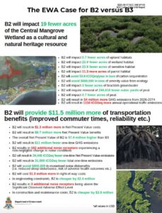
An addendum to the National Conservation Council letter compared the two proposed routes, stating that route B2 would affect nearly 24 fewer acres of sensitive habitat, avoid removing 240,000 cubic yards of peat and prevent 31,000 tonnes of one-time CO₂ emissions.
The Ministry of Planning, Lands, Agriculture, Housing and Infrastructure and the NRA stopped short of committing to the solar canopy, stating instead that while it may provide “a tangible cost benefit,” there are also “many intangible benefits” – from safety improvements to economic growth – that make the project a critical investment in Cayman’s future.
The ministry-NRA response went on to say that the chosen route would increase climate resilience “by providing a central inland route when coastal roads are affected.”
Although the environmental impact assessment did not factor sea level rise from climate change into its project modeling, it projected a rise of up to 1.64 feet over the road’s lifespan.
While sections of route B3 lie further inland and are less exposed to a receding coastline, environmental advocates have warned that disturbing the surrounding wetlands could compromise natural flood defences for nearby communities, heightening flood risks as sea levels continue to rise.
Cost-benefit
The Environmental Impact Assessment has projected that the East-West Arterial extension would cost an average of CI$18 million per year over the next 50 years, excluding inflation. These costs are expected to be offset by the project’s long-term social and economic benefits.
In an addendum to the National Conservation Council letter, route B2 was estimated to have a net present value approximately US$7.4 million higher than route B3. However, the ministry and the NRA have rejected this conclusion, emphasising that the difference is statistically insignificant.
“The cost-benefit ratios for B2 and B3 are comparable,” read the written response. “The figures referenced by the National Conservation Council appear to be drawn from the consultant’s Present Value of Benefits (PVB) cost comparison for the “Excellent Fit” road options. It is important to note that these values represent cumulative benefits projected over a 48-year analysis period.”
The apparent variance between both routes, according to the ministry and the NRA, amount to around US$240,000 per year, which the statement referred to as “a relatively minor difference in the context of a major national infrastructure project of this scale.”
The NRA added that such minor discrepancies can be addressed “through design optimisation, mitigation measures, and the long-term socio-economic gains associated with route B3’s superior land-use potential and alignment with national development objectives”.
The ministry further underscored that the East-West Arterial, like similar infrastructure investments in Jamaica, Trinidad and Tobago and Guyana, is designed to support sustainable, long-term economic growth and bring a range of tangible and intangible benefits such as attraction of foreign investment, reduced business costs and improved quality of life.
Related Videos


The road is pushed by politicians and their “supporters” who own land along side the route and will see their land values go up tenfold when the road connects their land. The NRA’s has also said the road wont do much in terms of relieving traffic so that should be a big red flag. This road is mean to open the wetlands up for construction so the greedy developers can destroy the remaining nature of this island that only exists today because nobody can access it. People wake up you are being fooled
New Landfill north of B2 or B3 needs to be included in this future road development. Exist Landfill only has a 5-7 years life span left!
Having a alternative roadway is good for logistics and transportation planning, especially if the one roadway is closed by a major event or disaster, such as floods or storm erosion. However, let no one be fooled by thinking that the proposed EWA will improve traffic congestion or the long commuting times that drivers from the eastern districts now endure. The data suggests a 10-15 minute savings in commute time into George Town from the east, based on current growth trajectory. Despite tens of Million$ in cost for the EWA.
We need a PLAN! What is our Carrying Capacity? How much can our small Islands bear/burden? What is the optimum Population limit for our Islands?
Even with short-term solutions such as public transportation, staggered-time etc. we are only buying time. Unless we had large tracks of Land and Billions of $$dollars to spend…which we do not. Sadly, We are kicking the can down the road. It is time for intellectual and political courage.