
For the latest information on storm activity in the Cayman Islands, as well as information on how to prepare for hurricane season, visit Storm Centre.
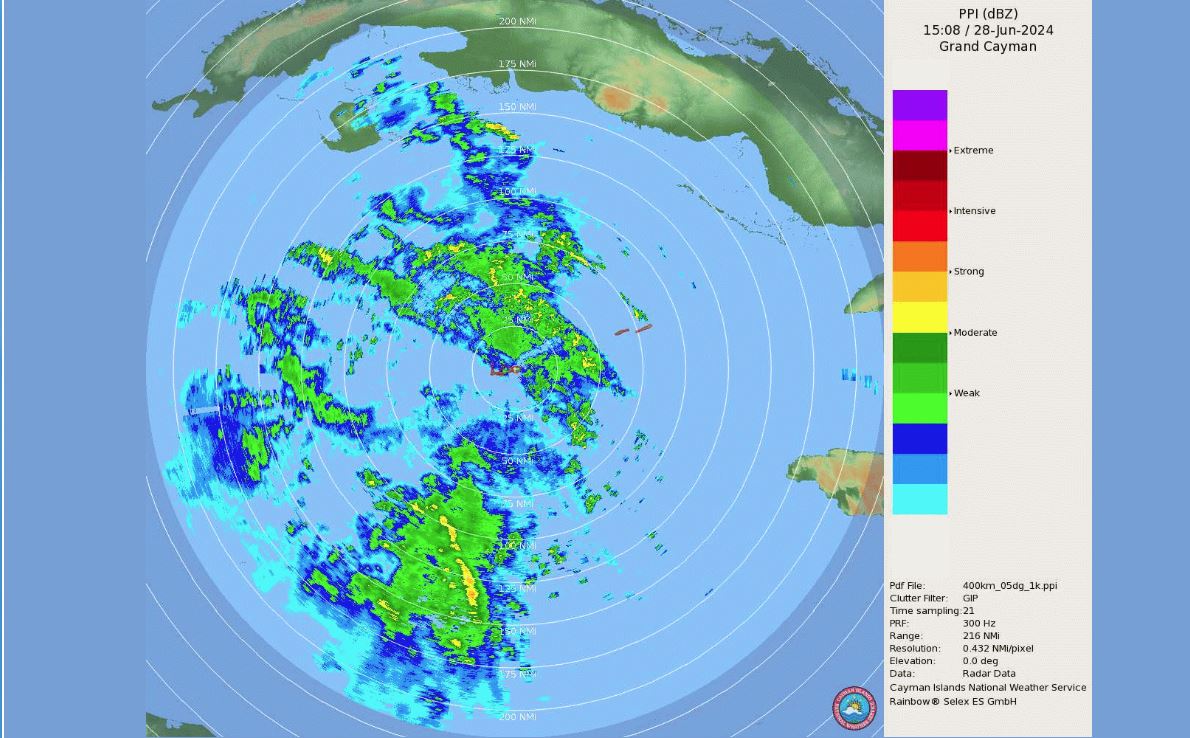
The Constitution Day long weekend looks likely to be a wet one as heavy rains lingered around the Cayman area on Friday.
Meanwhile, forecasters are monitoring a developing system nearing the Windward Islands that could become an issue for the Caribbean next week.
The National Weather Service, in its Friday forecast, said abundant moisture associated with a tropical wave just west of Grand Cayman continues to “propagate towards the northwest”, supporting periods of moderate to heavy thundershowers through Friday.
“Showers are expected across all islands with higher risk of flooding likely for Grand Cayman. A decrease in cloudiness and showers [is] expected overnight as the tropical wave moves northwest towards the Yucatan peninsula,” the forecast stated.
A government advisory on the weather, which was issued Friday afternoon, indicated that the Cayman Islands is currently experiencing rainy weather conditions associated with a broad area of low pressure, located several hundred miles southwest of Grand Cayman.
“This area of low pressure is moving west-northwest toward the Yucatan Peninsula and poses no significant threat. However, we can expect widespread shower and thunderstorm activity influencing local weather conditions in the Western Caribbean Sea,” it stated.
Isolated showers are possible for Saturday and Sunday with a slight chance of isolated thundershowers.
Moderate easterly winds of 10-15 knots and moderate seas of 3-5 feet are expected.
The forecast is also calling for a slight chance of isolated thundershowers on Monday.
In the central tropical Atlantic, forecasters are also keeping a close watch on a low pressure system identified as AL95.
Hazard Management Cayman Islands and the Cayman Islands National Weather Service, in the advisory, have urged the public to remain vigilant this hurricane season.
The Weather Service said it is monitoring the AL95 weather system, “which does not pose an immediate threat to the Cayman Islands”, adding that any updates on this system will be shared via official channels and media.
The system, located about 1,500 miles east-southeast of the Windward Islands, is gradually becoming better defined, the US-based National Hurricane Center said in its Friday morning advisory.
“Showers and thunderstorms are also showing signs of organization, and a tropical
depression or tropical storm will likely form later [Friday] or on Saturday. This system is expected to move westward at 15 to 20 miles per hour and approach the Lesser Antilles by the end of the weekend,” the advisory said.
When the system forms it will be named Beryl, the second named storm of the 2024 Atlantic Hurricane season.
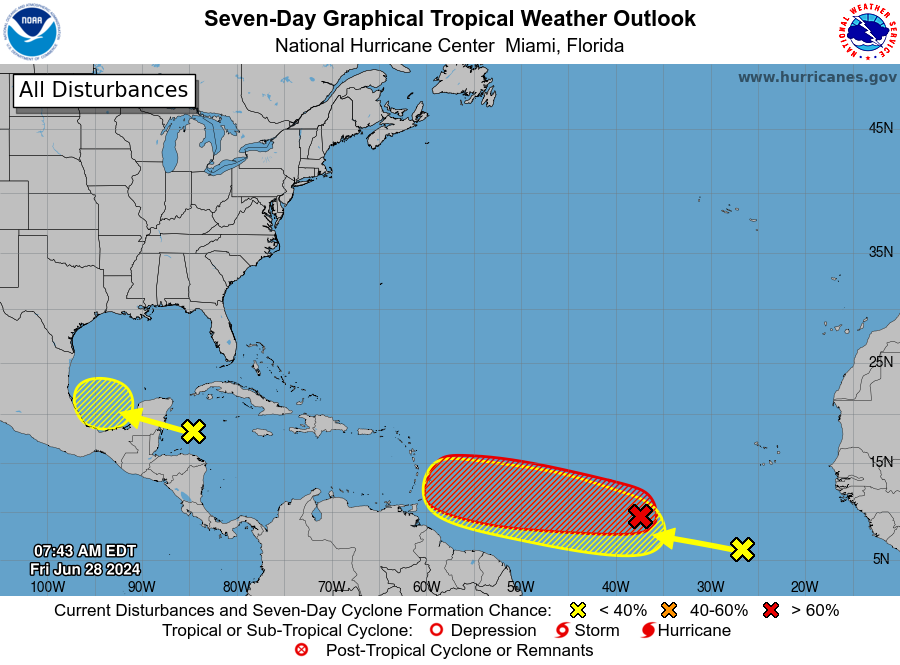
The NHC has advised interests in the Caribbean to monitor the progress of this system.
The system now has a 100% chance of formation through the next 48 hours.
Although the Cayman Islands is not currently threatened by AL95, residents are encouraged to be prepared and stay informed, Hazard Management has said.
“I would like to remind everyone to be prepared at all times during what’s predicted to be a very active hurricane season and to follow the official channels for accurate weather updates,” Danielle Coleman, director of HMCI, said during an internal briefing.
Coming on the heels of that system is a tropical wave in the eastern tropical Atlantic.
The tropical wave is centered several hundred miles south-southwest of the Cabo Verde Islands and is producing disorganised showers and thunderstorms.
The NHC said some slow development of this system is possible next week as it moves generally westward across the central and western tropical Atlantic at 15 to 20 miles per hour.
The wave has a 20% chance of formation over the next seven days.
Related Videos


