
The recent calm in the Atlantic basin could change in the coming weeks as forecasters say global models have detected “a robust signal for a tropical cyclone emerging from the western Caribbean in 8–12 days”.
Colorado State University’s Tropical Meteorology Project highlighted this signal in its latest forecast on Tuesday afternoon for the period of 17–30 Sept., saying, “this system could be strong and consequently generate moderate Accumulated Cyclone Energy (ACE), although ACE generation could be somewhat tempered due to a relatively short lifetime”.
Forecasters say regardless of how much ACE the system generates, “any development in the western Caribbean should be closely monitored for potential landfall impacts”.
It also indicated that models highlight potential tropical cyclone formation in the eastern and central Main Development Region later this month.
“The Madden-Julian Oscillation (MJO) is forecast to progress into the Western Hemisphere and potentially over Africa later in the forecast period, leading to more hurricane favorable large-scale conditions late in September,” the forecast added.
The primary threat formation area for major hurricanes in mid-to late September is in the eastern and central tropical Atlantic, the forecast said.
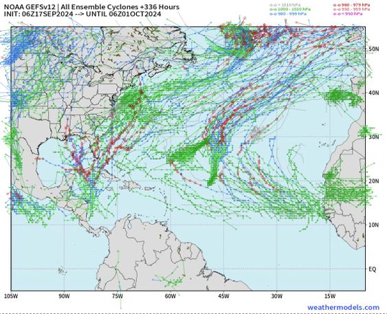
The forecast says the European Centre for Medium-Range Weather Forecasts Ensemble Prediction System (ECMWF EPS) and NOAA’s Global Ensemble Forecast System (GEFS) “both are highlighting the potential for tropical cyclone formation in the western Caribbean during the latter part of September. These ensembles also indicate that Gordon may redevelop in a few days”.
Over the next two weeks, however, the CSU forecasters say they “slightly favor” normal activity ACE over below-normal activity, which means some severe weather conditions could develop.
The US National Hurricane Center is currently monitoring a system in the northwestern Caribbean Sea with a 20% chance of formation over seven days.
“An area of low pressure could form this weekend over the western Caribbean Sea,” the US NHC said. “Thereafter, some slow development of this system is possible through early next week while the system moves slowly to the north or northwest over the northwestern Caribbean Sea.”
Meanwhile, Gordon, once a tropical storm, remains on the radar after being declared a post-tropical system. The system does not pose a threat to the Caribbean.
The CSU team said the system does have some re-formation potential in a few days when it distances itself from a non-tropical area of low pressure.
“At that point, it could generate a bit of ACE,” the forecast said.
The remnants of Gordon, the US-based National Hurricane Center said on Tuesday afternoon, is generating disorganised showers and thunderstorms over the central tropical
Atlantic.
“This disturbance is forecast to interact with a non-tropical low to its north while moving north-northeastward at 5 to 10 mph during the next couple of days. Environmental conditions could become more conducive for redevelopment later this week, and a tropical
depression or storm could form by this weekend while the system moves slowly northward over the central subtropical Atlantic,” the NHC said.
The system has a 60% formation chance over the next 7 days and a 30% formation chance over 48 hours.
CSU’s next two-week forecast will be issued on 1 Oct. for the 1–14 Oct. period and an additional two-week forecast will be issued on 15 Oct.
Related Videos


I’m not sure why we are highlighting hurricane forecasts from Colorado State University. I always put my money on the National Hurricane Center, which at present shows no development in the Eastern Atlantic off Africa, so we will not suffer a major hurricane this month.