
Speculative social media posts are generating fear in the Caribbean, claiming a massive earthquake is imminent in the region.
Ilias Papadopoulos, engineering seismologist at the University of the West Indies’ Seismic Research Centre, said a recent YouTube video from The St Vincent Times, viewed by nearly 50,000 people over the past week, was alarmist in its claims of a looming earthquake threat.
“The podcast states what is already known for the region, that large earthquakes can happen. They just use certain phrases to create panic to viewers,” Papadopoulos explained.
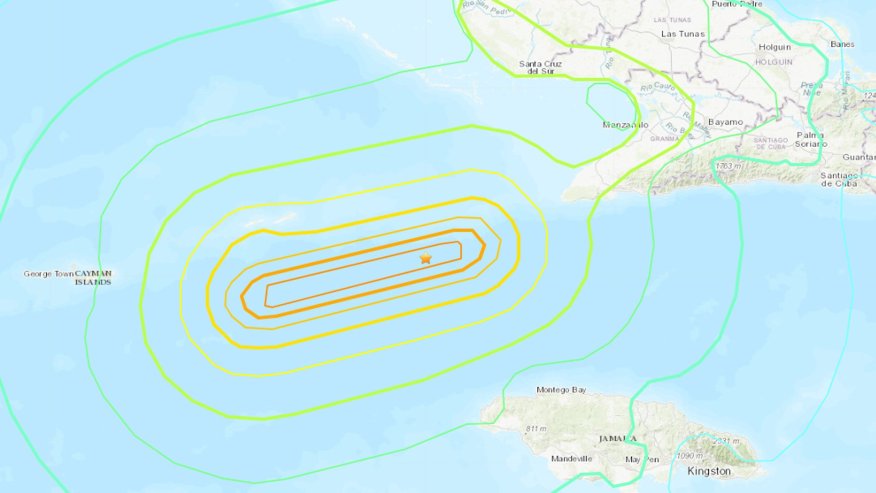
There have been a number of earthquakes in the region in recent weeks, including a 6.8 magnitude earthquake that struck southeastern Cuba on 10 Nov.
Hazard Management Cayman Islands Director Dani Coleman told the Cayman Compass that her team has been in contact with the Caribbean Disaster Emergency Management Agency and the University of the West Indies, and there is “no definitive evidence to support the conclusion there is an unusual or an elevated risk of an earthquake occurring near the Cayman Islands”.
For many years, Hazard Management has been going into schools, providing presentations about the appropriate way to prepare and respond in the event of an earthquake, and offering free hazard awareness presentations to businesses, government departments, church groups and non-profits. It also has preparedness information on its website.
Coleman encouraged people to reach out to Hazard Management and arrange a presentation.
“While there is always a remote possibility of a significant earthquake occurring because of our location close to a transform or strike slip boundary line, these events are incredibly rare, but that doesn’t mean we should ignore the earthquake threat altogether,” she said.
“Of course, we should all know how to respond to keep ourselves safe when we feel the ground shake.”
She added, “Residents should be aware of the ‘duck, cover and hold’ procedure during a tremor.”
Other strategies to mitigate the threat beforehand, she said, include securing bookshelves to walls and moving heavy items down to lower shelves to decrease the risk from falling objects.
Cayman’s seismic features
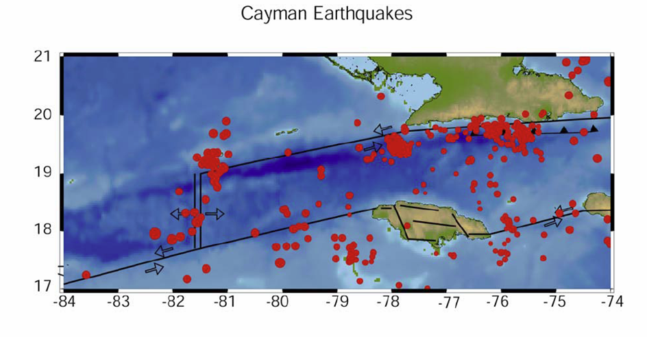
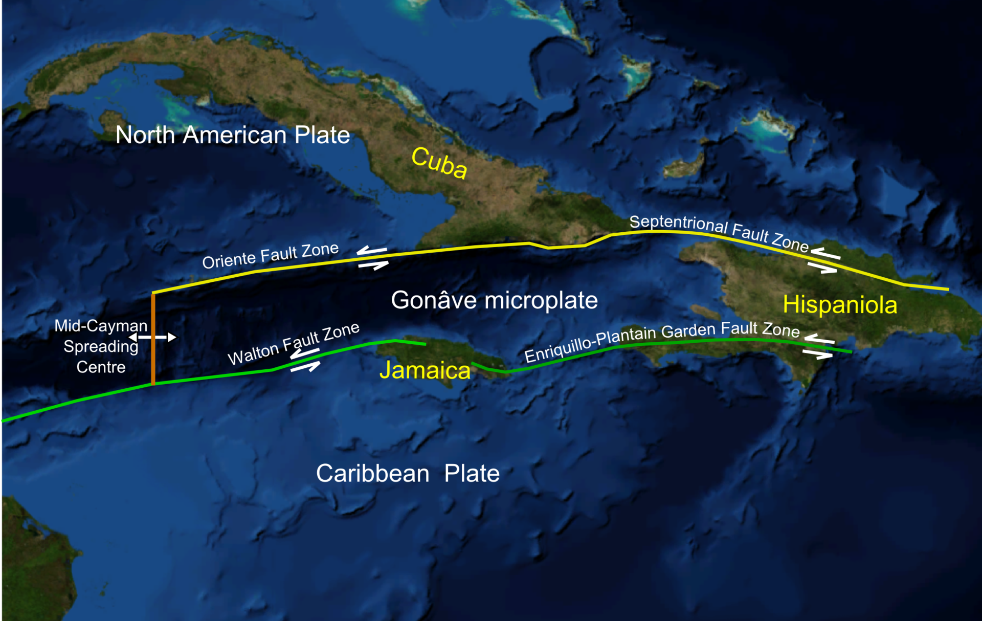
The Cayman Islands is located in a seismically active area, and while earthquakes occur infrequently, they can occur at any time and without warning. Just to the south of Cayman is the Cayman Trough, an 870-mile-long and 60-mile-wide oceanic depression with a maximum depth of over 23,000 feet that extends from southeast Cuba in the east and to Honduras in the west.
The Cayman Trough is a tectonic plate boundary between the North American plate, which moves westward with respect to the Caribbean plate at a rate of 15-20 millimetres a year. As a result of this differential motion, earthquakes sometimes take place along the plate boundary.
In December 2004, residents of the Cayman Islands felt a 6.8-magnitude earthquake that occurred 20 miles south of Grand Cayman. More recently, on 28 Jan. 2020, a 7.7-magnitude earthquake occurred, with the epicentre located approximately 80 miles east of Cayman Brac.
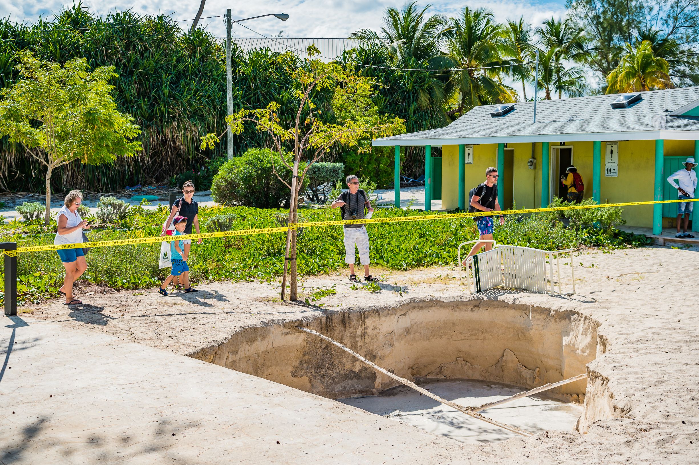
While there was very little structural damage reported following the large 2020 quake, more than 50 sinkholes opened up in various locations across Grand Cayman, and there were numerous small aftershocks in the days after the event. In Cuba, the event damaged 300 homes and killed one person.
A number of other large earthquakes (larger than 7.0 in magnitude) have occurred in our region in the last few decades. The Swan Islands Transform Fault, located southwest of the Cayman Islands, generated two of the largest strike-slip earthquakes in the Caribbean – a magnitude 7.3 event in 2009 and a magnitude 7.8 event in 2018.
On the Oriente Fault, which runs south of the Cayman Islands towards eastern Cuba, in addition to the 7.7-magnitude event experienced in 2020, there was a 7.7-magnitude earthquake in 1852 and a 7.4-magnitude event in 1917.
The ‘forgotten hazard’
The Cayman Islands Government installed a local seismic monitoring network over 30 years ago. However, there is no seismologist in the Cayman Islands, so at the present time, the Cayman Islands Government cannot triangulate the location of local tremors. The United States Geological Survey is the official source of seismic event information.
“Earthquakes are sometimes more challenging to prepare for, because they happen infrequently. Some people called them the ‘forgotten hazard’, and people tend to ignore or forget about the earthquake threat,” Coleman said.
“We are also fortunate in the Cayman Islands that we have robust planning laws, our building codes are enforced, and they include seismic load components that help mitigate the threat. So, our built environment and structures are relatively strong, and typically well able to withstand even quite significant shaking events.”
The Cayman Islands uses the 2009 International Building Code, which does not address design criteria for specific magnitude earthquakes; rather it gives design coefficients for buildings based on regional seismic zones, seismic hazard exposure groups and seismic performance categories. One such coefficient that is used is the peak ground acceleration, which is a measure of earthquake acceleration on the ground.
Related Videos


