
Cayman’s National Weather Service radar is currently down for repairs after a suspected lightning strike, NWS Director General John Tibbetts confirmed.
Tibbetts, in an emailed response to queries from the Cayman Compass Tuesday, said the Kearney Gomez Doppler Radar went down Friday.
However, he said the issue with the radar is being resolved and it will be up and running by Wednesday, 18 Aug.
He explained that the generator at the radar site in High Rock in East End went offline and it is believed this was triggered by a possible lightning strike, but that was “unconfirmed”.

At present, the NWS site and weather notices have advised the public that the radar is down for maintenance.
The director general said repairs to the radar will cost about $7,500.
With the radar down, Tibbetts said, NWS now has no system that shows showers “but heavier convective activity can be seen on satellite systems”.
Tibbetts said the public should not be concerned by the temporary absence of the radar as “the weather service can continue to provide forecasting of showers”.
With hurricane season under way, though, Tibbetts said the value of the radar increases if storms come close to Cayman.
However, he said the current storm, which is in set to be named Fred later today, is located in the eastern Caribbean “far outside the range of the radar”.
Hazard Management Cayman Islands, in a Facebook post, said tropical storm conditions are not expected to impact Cayman, “with the forward looking models (currently) placing the storm on a path well north of the Cayman Islands”.
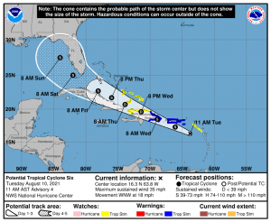
The US National Hurricane Center in Miami has said Hurricane Hunter aircraft reported the disturbance is not yet a tropical cyclone, but is likely to become a tropical storm later Tuesday.
“The system is moving toward the west-northwest near 18 mph (30 km/h) and this general motion is expected to continue during the next few days. On the forecast track, the disturbance is expected to pass near or over the U.S. Virgin Islands and Puerto Rico later today and tonight, be near or over Hispaniola on Wednesday, and be near the southeastern Bahamas and the Turks and Caicos Islands Thursday,” the NHC said in its 11am advisory.
Maximum sustained winds are near 35 mph with higher gusts.
“Gradual strengthening is forecast during the next day or so and the disturbance is expected to become a tropical storm later today or tonight. Some weakening is likely while the system interacts with Hispaniola on Wednesday,” it added.
The storm has a high chance formation of 90% through 48 hours.
The next update is expected at 2pm.
For the latest information on storm activity in the Cayman Islands, as well as information on how to prepare for hurricane season, visit Storm Centre.
Related Videos


