For the latest information on storm activity in the Cayman Islands, as well as information on how to prepare for hurricane season, visit Storm Centre.
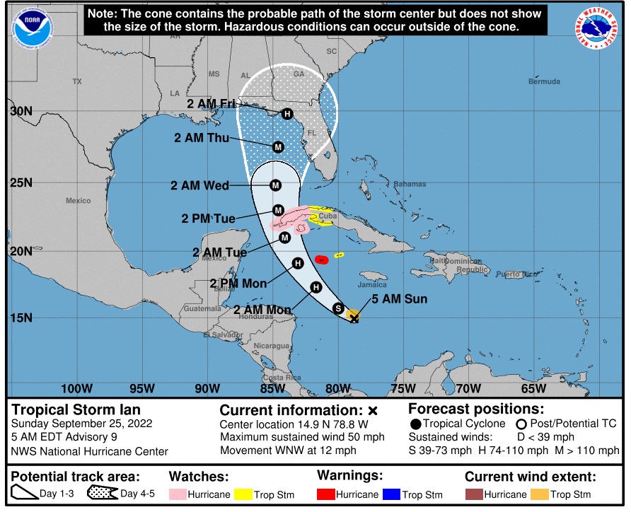
Update: 4.45am, Sunday, 25 Sept.:
A hurricane warning remains in effect for Grand Cayman, as Tropical Storm Ian continues on its path through the Caribbean Sea.
As of 4am Sunday, it was 345 miles south-southeast of Grand Cayman, moving at 12 miles an hour, with maximum sustained winds of 50mph.
A tropical storm watch is in effect for Little Cayman and Cayman Brac.
According to the US National Hurricane Center, the storm is forecast to continue moving westward before taking a turn northwestward later today, passing the Cayman Islands on Monday morning, and approaching western Cuba as a major hurricane on Monday night or early Tuesday.
The Cayman Islands National Weather Service, in its 4am update, said Grand Cayman can expect the onset of tropical storm-force winds from 4am Monday, and those will continue until 3pm Monday.
The closest point of approach is predicted to be 99 miles southwest of Grand Cayman at 8am Monday.
If the storm continues on its current path, Cayman forecasters say, Grand Cayman may experience widespread thunderstorms from Sunday morning, with tropical storm conditions late into the night and possible hurricane conditions from early Monday morning as the system nears the Cayman Islands. Extremely rough seas accompanied by storm surge are also expected. Swell generated by Ian will spread into the Cayman area later Sunday.
Similar conditions are expected for the Sister Islands, but the possibility for storm-force winds are lower there, the NWS forecasters said.
According to the National Hurricane Center, the storm is expected to rapidly intensify later Sunday, and Ian is likely to be a major hurricane when it nears western Cuba in about 48 hours.
A flood warning will be in effect for the Cayman Islands, with rainfall of up to 4 inches expected on Monday.
Gusty winds are likely across all three islands from Sunday night. On Grand Cayman, winds of 20-30 miles per hours are expected on Sunday night, followed with winds of 45-55mph, with higher gusts, on Monday morning. On the Sister Islands, winds of 15-20mph, with higher gusts, are expected on Sunday and Monday.
A marine warning will be in effect for all three islands, and all marine craft are advised to seek and remain in safe harbour. Estimated wave heights of 6-8 feet are expected Sunday, rising to 10-13 feet, especially along the south coast on Monday. Swells of 5 to 7 feet are likely, along with 1 to 3 feet of storm surge, forecasters said.
The next weather update from the National Weather Service is scheduled for 10am.
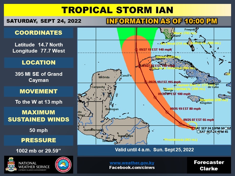
Update 10:30pm, Saturday, 24 Sept.:
In its latest bulletin, the Cayman Islands National Weather Service reported that maximum sustained winds of Tropical Storm Ian have increased to 50 miles per hour.
As of 10pm, the storm was located about 395 miles southeast of Grand Cayman. The storm is moving towards the west at 13mph.
Ian remains a tropical storm, as sustained winds of 74mph are required for a system to be categorised as a hurricane.
Based on its current forecast path, Ian is expected to bring tropical storm-strength winds to Grand Cayman from 1am Monday morning.
The centre of the storm is expected to be closest to Grand Cayman – 99 miles southwest of the island – around 8am Monday.
Tropical storm-force winds are forecast to dissipate around 3pm Monday, the National Weather Service said.
If the storm continues on its current path, Cayman forecasters say Grand Cayman can expect overcast skies with widespread thunderstorms from Sunday, with tropical storm conditions arriving late into the night.
Tropical storm-force winds with possible hurricane-force gusts are expected for Grand Cayman by early Monday morning as the system moves more west of the Cayman area.
Extremely rough seas accompanied by storm surge are also expected.
Cayman Brac and Little Cayman can expect similar conditions, though “given the adjustments to forecast track, the possibility for storm force winds are lower for the Sister Islands”, the National Weather Service stated.
A flood warning will be in effect for the Cayman Islands as the storm impacts the islands.
On Sunday, 1-2 inches of rainfall is expected, with 2-4 inches falling on Monday, and 1-2 inches on Tuesday.
On Grand Cayman, winds from the southeast, at 20-30 miles per hour, are forecast for Sunday night, while Monday morning is expected to bring winds of 35-45mph, with higher gusts. By Monday afternoon, winds of 20-30mph are expected, falling to 20-25mph by Monday evening.
On the Sister Islands, winds of 15-20mph, with higher gusts, are expected on Sunday, and 15-20mph, with higher gusts, on Monday.
A marine warning will be in effect for the Cayman Islands, as wave heights are predicted to be 6-8 feet, especially along the south coast of Grand Cayman, on Sunday. On Monday, wave heights are likely to be 9 to 12 feet.
On Tuesday, swells of 5 to 7 feet are likely, along with 1 to 3 feet of storm surge.
The National Weather Services will issue its next bulletin at 4am Sunday.
Update 5pm Saturday, 24 Sept.: The National Weather Service, in its latest bulletin, has said a marine warning will be in effect for the Cayman Islands, and has advised all marine craft to seek and remain in safe harbour.
Cayman is preparing for Tropical Storm Ian, which is projected to become a Category One hurricane as it approaches Grand Cayman early Monday morning.
In its latest update, the NWS said estimated wave heights of 6 to 8 feet are expected Sunday, especially along the south coast, with increases to 9 to 12 feet on Monday.
Swells of 5 to 7 feet are likely, along with 1 to 3 feet of storm surge.
Wave heights of 5 to 7 feet can be expected Tuesday.
As of 4pm Saturday, Tropical Storm Ian was located about 445 miles south east of Grand Cayman with maximum sustained winds of 45 miles per hour.
Tropical Storm Ian is moving towards the west at 16 miles per hour with minimum central pressure of 1003mb, 29.62 inches.
Given the instability of the storm, the onset of tropical storm force winds for Grand Cayman has been revised to 4am Monday.
The closest point of approach is now projected as the center being 118 miles south west of Grand Cayman at 6am Monday.
The end of Tropical Storm force winds for Grand Cayman is now projected for 9am Monday.
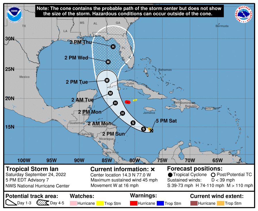
This is contingent on the storm’s current projected path, as of Saturday evening.
Expected weather conditions for the Cayman Islands include overcast skies with widespread thunderstorms from Sunday, with tropical storm conditions late into the night as the system nears the Cayman Islands.
“Tropical Storm force winds with possible hurricane force gusts are expected for Grand Cayman by early Monday morning as the system moves more west of the Cayman area. Extremely rough seas accompanied by storm surge are also expected,” the bulletin stated.
On the Sister Islands, overcast skies along with widespread thunderstorms are expected from Sunday as Tropical Storm Ian moves closer to Cayman.
“Extremely rough seas along with swells and storm surges are also expected due strong and gusty winds. Given the adjustments to forecast track the possibility for storm force winds is lower for the Sister Islands,” it added.
A flood warning will also being in effect for the island as the estimated rainfall Sunday to Tuesday will range between 1 to 4 inches.
Gusty winds are also expected to begin Sunday night.
Expected winds speeds
Grand Cayman
Sunday Night: SE at 20 to 30 mph
Monday Morning: 35 to 45 mph with higher gusts
Monday Afternoon: 20 to 30 mph
Monday Evening: 20 to 25 mph
Sister Islands
Sunday: 15 to 20 mph with higher gusts
Monday: 15 to 20 mph with higher gusts
Update 1:30pm Saturday, 24 Sept.: The Cayman Islands government has upgraded the the existing hurricane watch to a hurricane warning for Grand Cayman, and Little Cayman and Cayman Brac have been downgraded to a tropical storm watch.
Cayman Islands National Weather Service Director John Tibbetts, in an interview with the Cayman Compass Saturday afternoon, said the current forecast track for the system has Ian passing south of Grand Cayman and coming up to the west. The centre of the storm is expected to come within 68 miles west of Grand Cayman.
“As it’s approaching the area, it is expected to reach Category 1 hurricane status and, as it’s moving north of us, it is forecast to become Category 2 level. So it is a system that is strengthening as it passes to the west of us.”
A hurricane warning means that hurricane conditions are expected somewhere within the warning area.
“A warning is typically issued 36 hours before the anticipated first occurrence of tropical-storm-force winds, conditions that make outside preparations difficult or dangerous. Preparations to protect life and property should be rushed to completion,” the US National Hurricane Center explained in its latest advisory.
The storm is about 505 miles southeast of Grand Cayman and has maximum sustained winds of 45 miles per hour with higher gusts.
The Onset of Tropical Storm Force Winds for:
· Grand Cayman is: Mon Sep-26, 1:00 AM
The closest point of approach:
· Center is 68 miles SW of Grand Cayman: Mon Sep-26, 6:00 AM
End of Tropical Storm force winds for:
· Grand Cayman is: Mon Sep-26, 4:00 PM
The NHC said it expects the storm to “rapidly intensify” later this weekend.
Ian is moving toward the west near 16 mph and this general motion is expected to continue through tonight.
“Significant strengthening is forecast during the next few days. Ian is expected to become a hurricane late Sunday or Sunday night and could be at or near major hurricane strength late Monday when it approaches western Cuba. Tropical-storm-force winds extend outward up to 60 miles (95 km) from the center,” the NHC said.
A turn toward the northwest is forecast on Sunday, followed by a north-northwestward turn on Monday and a northward motion on Tuesday. On the forecast track, the centre of Ian is forecast to pass southwest of Jamaica on Sunday, and pass near the Cayman Islands Sunday night and early Monday. Ian will then approach western Cuba late Monday and emerge over the southeastern Gulf of Mexico on Tuesday, according to the NHC..
Update 11:30am Saturday, 24 Sept: Grand Cayman can expect to start experiencing tropical-storm-force winds on Monday, 26 Sept. from around 1am if Tropical Storm Ian remains on its current track, the National Weather Service advised in its latest severe weather bulletin.
The NWS said that at this time the Cayman Islands still remains under hurricane watch, as Ian continues to move through the Caribbean Sea.
In its latest bulletin, NWS said at 10am the centre of Ian was located near latitude 14.4° north and longitude 75.2° west which places TS Ian about 520 miles southeast of Grand Cayman.
“The system is moving towards the west at near 15 miles per hour, with maximum sustained winds near 45 miles per hour, with higher gusts. The closest point of approach places the centre at 68 miles south west of Grand Cayman around 6am,” on Monday, it said.
The NWS said overcast skies with widespread thunderstorms are expected from Sunday with tropical storm conditions late into the night as the system nears the Cayman Islands.
As of this latest bulletin, tropical-storm-force winds extend outward up to 60 miles from the centre.
“Tropical storm force winds with possible Hurricane force gusts are expected for Grand Cayman by early Monday morning. Extremely rough seas accompanied by storm surge are also expected,” it added.
Tropical-storm-force winds are expected to end by 4pm on Monday, 26 Sept.
The Cayman Islands Airports Authority advised late Friday that it is closely monitoring the approaching storm, and “based on current projections and weather conditions Owen Roberts International Airport on Grand Cayman and Charles Kirkconnell International Airport on Cayman Brac will cease Airport Operations at 4:00 p.m. Sunday, 25 September 2022. We anticipate resuming Airport Operations on Tuesday, 27 September 2022.”
Original story
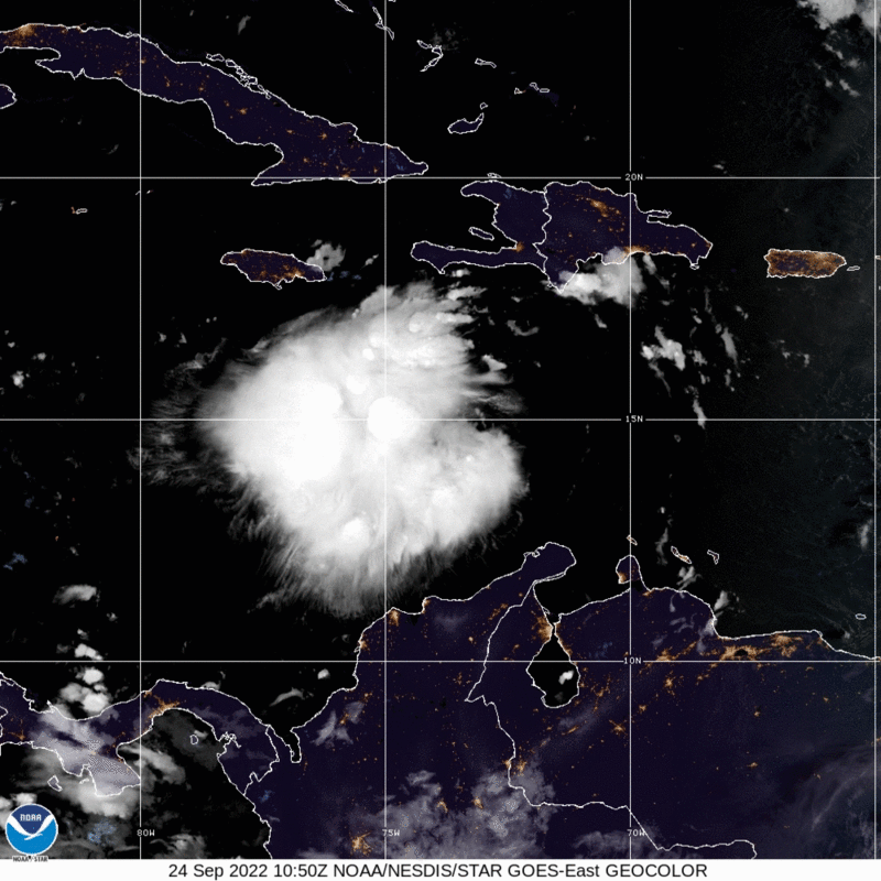
Tropical Storm Ian continued to strengthen overnight as it makes its way through the central Caribbean and towards the Cayman Islands.
The storm, as at 8am Saturday, was located about 570 miles south east of Grand Cayman.
In its 8am advisory, the US National Hurricane Center in Miami said Ian’s maximum sustained winds were near 45 miles per hour with higher gusts.
Tropical-storm-force winds extend outward up to 45 miles from the center.
The Cayman Islands National Weather Service, in its 7am advisory, said overcast skies with widespread thunderstorms are expected from Sunday, with tropical storm conditions late into the night as the system nears Cayman.
“Hurricane force winds are expected for Grand Cayman by early Monday morning. Extremely rough seas accompanied by storm surge are also expected,” it added.
The storm, the 6th for the 2022 Atlantic Hurricane Season, is moving toward the west-southwest near 15 miles per hour.
“A westward to west-northwestward motion is expected through early Sunday. A turn toward the northwest is forecast late Sunday, followed by a north-northwestward turn by late Monday. On the forecast track, the center of Ian is forecast to move across the central Caribbean Sea today, pass southwest of Jamaica on Sunday, and pass near or over
the Cayman Islands Sunday night and early Monday. Ian will then approach western Cuba on Monday,” the NHC said.
Further strengthening is forecast during the next few days, and Ian is expected to become a hurricane late Sunday or Sunday night.
The estimated minimum central pressure is 1004 mb or 29.65 inches.
Rough seas may start late Saturday
The Cayman Islands remains under a Hurricane Watch in anticipation of the forthcoming severe weather conditions.
This is expected to be elevated to a warning later on Saturday.
A Hurricane Watch means that hurricane force winds are likely to impact the Cayman Islands within 48 Hours, while a Hurricane Warning is issued when sustained winds of 64 knots or 74 miles per hour or higher, associated with a tropical cyclone, are expected in 36 hours or less.
The NHC said hurricane conditions are possible in the Cayman Islands by early Monday morning, with tropical storm conditions possible by Sunday night.
Tropical storm conditions are possible on Jamaica on Sunday.
Ian is expected to produce 4 to 8 inches of rainfall, with a local maximum of up to 12 inches.
Storm surge could raise water levels as much as 1 to 3 feet above normal tide levels along the immediate coast in areas of onshore winds in Cayman Sunday night into Monday.
“Swells generated by Ian will begin affecting Jamaica, the Cayman Islands, and Cuba over the next several days. These swells are likely to cause life-threatening surf and rip current
conditions,” the NHC said.
Local stores keep normal hours Saturday
As Cayman prepares for Ian’s arrival, local hardware stores and supermarkets are set to open Saturday to allow the public to get needed supplies.
AL Thompson is open until 6pm and will open Sunday from 7am to 11am.
Uncle Bill’s Home Improvement Centre is open until 4pm Saturday and Cox Lumber will open until 7pm. Cox will open from 7am to noon Sunday.
Local supermarkets will keep normal Saturday opening hours.
They will not be open on Sunday nor Monday.
The retail banks have indicated all ATMs are being monitored and restocked as required.
Shelters
Hazard Management Cayman Islands has said hurricane shelters/emergency medical centres will be open to the public on Sunday 25 Sept.
The following hurricane shelters have been activated:
o Sir John A. Cumber Primary School
o John Gray High School (Pet friendly)
o Bodden Town Primary School
o Clifton Hunter High School (Pet friendly)
o East End Civic Centre
o Cayman Islands Red Cross Building
Each of the six shelters, with exception of the Red Cross Building, also serves as a designated Emergency Medical Centre.
The Aston Rutty Civic Centre in Cayman Brac will be open as an emergency shelter at 2pm on Sunday 25 Sept.
“Additional shelters activations across all three islands will be announced as needed, depending on the intensity and forecasted track of the tropical cyclone,” HMCI added in a post on its Facebook page.
Related Videos


