
Even as Cayman enjoys some short bursts of showery days, there will be no respite from the excessive heat experienced in July, according to the latest statistics from the National Weather Service.
In fact, the Caribbean Institute for Meteorological and Hydrology has said the Cayman Islands has a 70% probability of having maximum temperatures above average for the three-month period of July through September.
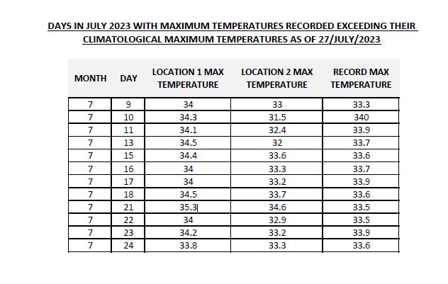
“The higher than normal heat indices have been contributed to by a number of days this month with high maximum temperatures which have been exceeding their climatological maximum temperature for their day,” NWS forecaster Kerrie Forbes told the Cayman Compass in a recent emailed comment.
The maximum temperatures that would normally be expected this time of the year in Cayman falls in the range of 31.9⁰C–32.3⁰C (89.4⁰F-90.1⁰F); however the National Weather Service says it expects temperatures to surpass the upper limit this summer.
Typically the range of minimum summer temperatures are 25.7⁰C-26.1⁰C (78.3⁰F-79⁰F).
Chief Medical Officer Dr. Nick Gent recently urged caution during peak heat hours, especially for outdoor workers and visitors unaccustomed to hot climates.
Though he said he had not seen a rise in heat-related complaints, Gent said he was concerned for employees in industries like construction.
Temperatures recorded by the National Weather Service in July showed that most days exceeded their previously recorded maximum with the highest temperature logged on 21 July.
That temperature crossed the 35⁰C mark, hitting 35.3⁰C (95.5⁰F) at one of the two locations (on the Owen Roberts airfield) where NWS records temperatures, with Forbes noting that the measurements collected from 1-30 July show “we have had 13 days of our maximum temperatures exceeding their day’s climatological record”.
The second temperature-recording location (across from Jose’s Rubis) reached 34.6⁰C (94.3⁰F).
The previous maximum recorded temperature for that date was 33.5⁰C (92.3⁰F).
The NWS monthly climate bulletin issued for July, stated that the community can expect a mid-summer dry spell through August.
“July to September, marking the peak of the Caribbean Heat Season (May to October) is forecast to be hotter than usual. Frequent and, possibly intense episodes of heat stress in the vulnerable population & small livestock because of high temperature and increasing humidity through September,” the bulletin advised.
It is expected that there will be a potential moderate heat impact, with a possible upper limit of extremely high heat for August and September.
“A possible transition into El Niño is often marked by a warmer heat season, a drier summer season, and reduced tropical cyclone activity,” the bulletin added.
Though the hot conditions are expected to continue, the bulletin indicates that there is no concern for short- or long-term drought conditions.
There is a 40% probability of above-average wet spells from July to September, with a 3.3-6.9 frequency of seven-day wet spells.
The Compass last week reported on rising sea temperatures, which could damage coral and intensify hurricanes.
Related Videos


Hopefully the radar installation won’t have another heart attack in these temperatures.