For the latest information on storm activity in the Cayman Islands, as well as information on how to prepare for hurricane season, visit Storm Centre.
As August comes to a close, the weather radar has come to life with three active systems now being monitored by forecasters.
The first system, a tropical wave located several hundred miles east of the Lesser
Antilles, is projected to develop into a tropical depression within the next couple of days, the US National Hurricane Center has said.
The Cayman Islands National Weather Service, in its latest weather forecast, said the National Hurricane Center has marked the tropical wave over the Central Atlantic Ocean with a 50% chance of cyclone formation in the next 7 days.
It said it will continue to monitor the development of this system.
Residents are also encouraged to monitor its development.
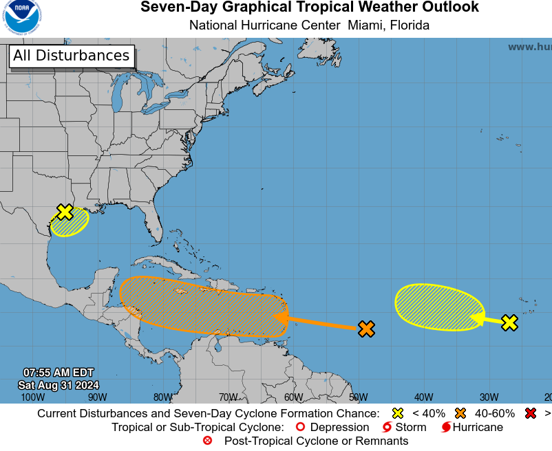
The topical wave continues to produce some disorganized showers and thunderstorms on Saturday morning, the NHC said.
“The disturbance is forecast to move westward and reach the Lesser Antilles on Monday. Thereafter, environmental conditions appear conducive for gradual development of this system, and a tropical depression could form while it continues moving westward across the Caribbean Sea through the middle to latter part of the week,” the NHC said in its Saturday morning advisory.
It has a medium, or 50%, chance of cyclone formation within the next seven days.
As for Saturday’s forecast, the Weather Service, said isolated showers are expected on Saturday due to residual moisture from a tropical wave currently west the Cayman Islands.
A decrease in cloudiness and showers is expected through tonight as the wave moves further west. Radar images show isolated showers in and around the Cayman Islands moving northwest.
However, another tropical wave is expected to move near the Cayman area by Monday evening, resulting in an increase in cloudiness and showers by that time.
The two other systems being monitored have been given a relatively low chance of development at this time.
One of the systems, a tropical wave, is located just to the west of the Cabo Verde
Islands, was producing disorganized shower and thunderstorm activity on Saturday morning.
The NHC said development, if any, should be slow to occur while the system moves
slowly westward to west-northwestward over the eastern and central tropical Atlantic through late next week.
At present it has a 10% formation chance through seven days.
The third system, presently in the northwestern Gulf of Mexico, is located near the upper Texas coast and was producing some disorganized showers and thunderstorms along and just offshore the coasts of Texas and Louisiana.
The broad area of low pressure, the NHC said, is expected to “linger near the coast” through much of next week.
“Some slow development is possible if it meanders offshore. Regardless of development, heavy rains could cause some flash flooding across portions of coastal Louisiana and the upper Texas coast during the next few days,” it added.
This system has a formation chance of 20% through seven days.
Related Videos


