
The Public Lands Commission has registered a formal objection to Dart’s proposed planned area development (PAD) for the area north of Governor’s Harbour.
The commission, responding to queries from the Cayman Compass about its position on the PAD, said it has reviewed the application and submitted comments to the Central Planning Authority as it relates to the project.
In its view, “the blocking of 24 public rights of ways over private land as proposed in this development is not supported by the Public Lands Commission”.
The PAD planning application, submitted by Dart’s Crymble Landholdings Ltd back in March, seeks permission for a mixed-use, resort and residential development over 157 acres.
The new town development, according to the original application, would have spanned an area from the Cayman Islands Yacht Club to Seven Mile Beach, and involved cutting a canal under the Esterley Tibbetts Highway bridge.
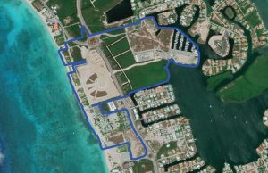
It would have also encompassed 24 beach accesses and public rights of way, all of which will be impacted by the future development.
The commission, in its statement, said it submitted objections to the proposed development on the basis of Section 5(b) of the Public Lands Act (2020 Revision).
“The Public Lands Commission is mandated to ‘protect the right of access to and use of public land by members of the public, including the enforcement of public rights of way over private land,'” it said, adding that it could not support such an application.
It was initially suggested that around 34 accesses would have been impacted. However, the commission said, upon further review of the Lands & Survey 2017 Beach Access Report, 24 public rights of ways over private land “will be encumbered or inaccessible to the public should the development proceed as planned”.
The commission said further recommendations were made to the Central Planning Authority, including that any approval should condition “a requirement for the developer to preserve, in their current locations, all public rights of ways over private land for future use by the public to facilitate access to public land (i.e. the beach)”.
Local group Cayman Beach Watch has also objected to the application and proposed work.
The PAD application covers Dart-owned lands currently zoned hotel/tourism and residential, anchored by the Kimpton Seafire Resort + Spa and the Cayman Islands Yacht Club and marina. The neighbourhood will also include the recently approved Seafire splash park and the new Hotel Indigo, subject to planning approval, a release on the application stated.
Justin Howe, Dart president of real estate asset management, through an emailed statement to the Compass Wednesday on the commission’s position, acknowledged the concerns in the community.
“As part of the planning application process, Dart is currently reviewing the comments submitted by government agencies in response to the proposed Planned Area Development (PAD) for a resort residential district in the Seven Mile Beach corridor,” he said.
Howe explained a PAD is essentially a “progressive, future forward planning tool” that promotes sustainable development by considering long-term land use, accessibility, infrastructure, public spaces and environmental management.
“It does not give permission to build, nor does the PAD application change how the public can access the beach. As every project within the PAD would require separate planning approval, it is our understanding that beach access would be addressed at that time,” he said.
Dart, Howe said, welcomes feedback on its development plans from stakeholders across the community and “remains committed to sustainable growth in the Cayman Islands”.
Within the proposed PAD area there are a few unregistered accesses and the commission said it is currently working on legislation to allow the registration of unregistered rights of way that are not in dispute.
However, as it stands currently, if an unregistered right of way is in dispute, a member of the public may apply to the Grand Court under Section 9 of the Prescription Act, or alternatively a member of the public may notify the Public Lands Commission of the blockage of the unregistered right of way for the PLC to take action under Section 9 of the Prescription Act.
The commission said it continues its work placing signs at registered beach accesses.
Outline of affected beach accesses and rights of way (Source: Public Lands Commission)
| Access Number | Block | Parcel | Location in Report |
| SMB 14 | 11B | 70 | Pages 191 and 219 |
| SMB 15 | 11B | 70 | Pages 190 and 221 |
| SMB 16 | 11B | 86 | Pages 190 and 223 |
| SMB 17 | 11B | 86 | Pages 190 and 225 |
| SMB 18 | 11B | 86 | Pages 190 and 227 |
| SMB 19 | 11B | 86 | Pages 190 and 229 |
| SMB 20 | 11B | 86 | Pages 190 and 231 |
| SMB 21 | 11B | 86 | Pages 190 and 233 |
| SMB 22 | 11B | 86 | Pages 190 and 235 |
| SMB 23 | 11B | 84 | Pages 190 and 237 |
| SMB 24 | 11B | 84 | Pages 190 and 239 |
| SMB 25 | 11B | 84 | Pages 190 and 241 |
| SMB 26 | 11B | 84 | Pages 190 and 243 |
| SMB 27 | 11B | 87REM1 | Pages 190 and 245 |
| SMB 28 | 11B | 87REM1 | Pages 190 and 247 |
| SMB 29 | 11B | 61 | Pages 190 and 249 |
| SMB 33 | 11B | 61 | Pages 190 and 251 |
| SMB 34 | 11B | 61 | Pages 190 and 254 |
| SMB 35 | 11B | 61 | Pages 190 and 256 |
| SMB 36 | 11B | 17 | Pages 190 and 258 |
| SMB 37 | 11B | 17 | Pages 190 and 261 |
| SMB 38 | 11B | 17 | Pages 190 and 264 |
| SMB 40 | 10E | 14 | Pages 190 and 266 |
| SMB 41 | 10E | 54 | Pages 190 and 268 |
Related Videos


This will end up happening anyway. It’s all optics. Oppose it in the beginning, have a couple of hearings, and the next thing you know there’s an article in the Compass announcing that it has passed. Same story-over and over. There is a finite amount of beautiful island. PROTECT IT!!
When you have 50 small parcels and you combine them into 1 large parcel for a more organized ‘planned’ development, you are by the nature of that development going to have to re-organize how some accesses run across the land. If you don’t make commonsensical changes to the way pedestrian and vehicular traffic runs, you wind up memorializing rights of way that have no purpose anymore or marginalizing the project for future visitors and residents. None of it will stop subsequent development. It just makes for a worse project for everyone. If the Lands Commission’s goal is to hold the developer to account and ensure public access is maintained, then that should be applauded. If some faction within Lands Commission is trying to derail a project that is good for Cayman under the false premise of marginalized access then those individuals within the Lands Commission (or the commission itself) should be identified and held to account by the people.