
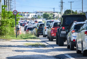
Commutes from North Side to George Town could clock in at well over two hours within a decade without extensive upgrades to the road network, National Roads Authority data suggests.
Traffic data modelling from the NRA projects that ‘rush hour’ – already a misnomer in the Cayman Islands – could soon extend for more than three hours.
Morning gridlock will start before 6am and won’t abate until after 9am within just a few years, the data suggests. And journey times from the eastern districts will almost double by 2036, when the population is expected to reach 100,000.
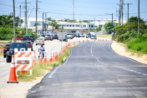
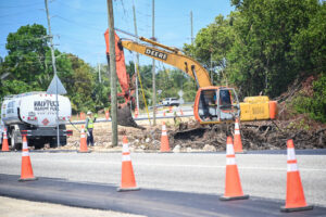
While government leaders have insisted that building roads is not the long-term fix to traffic issues, the NRA believes that overdue upgrades to the islands’ highway infrastructure are a big part of the immediate solution. Some of the work to expand Bobby Thompson Highway and add lane capacity along the Linford Pierson Highway has already taken place.
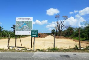
The full road-building programme, including a 10-mile expansion of the East-West Arterial, aims to ensure a network of four-lane highways is in place, spanning the entirety of Grand Cayman, from Frank Sound to West Bay.
That goal, according to senior NRA officials, is fundamental to developing any more progressive policies to deal with traffic.
Public transport with dedicated bus lanes, safe cycle paths and better town planning that positions more businesses and more jobs in the eastern districts will all be easier to achieve once that network is in place, Ed Howard, managing director of the NRA, told the Cayman Compass.
“What we’re trying to do now is build a primary road network,” said Howard. “For a long time we have relied on coastal roads that were developed 50 years ago. They were initially donkey trails.”
The NRA doesn’t expect the new roads to cut traffic times significantly. It says it is simply trying to catch up on overdue infrastructure upgrades and keep up with the amount of new cars coming on to Cayman’s roads every year.
Two possible futures
The authority uses a sophisticated software programme to project the impact of additional vehicles, new lanes or policy interventions on traffic in Cayman.
Forecasting an increase in cars on the road, linked to population growth, it examined what
journey times could look like in 2026 and 2036, compared to baseline data from
2018.
One scenario factored in the East-West Arterial expansion and the widening of roads around George Town. The other examined the ‘do nothing’ approach.
By 2026, NRA officials say, a sample rush-hour journey from Old Man Bay to the airport will have increased from a current average of 62 minutes to 78 minutes, rising to almost two hours by 2036, when the model projects Cayman’s population will have reached 100,000.
Even with the planned expansion to the road network, including the new 10-mile highway linking Savannah to Frank Sound, journey times won’t decrease.
In fact, the model predicts they will continue to rise, just at a slower rate.
That airport run from North Side will take 72 minutes in 2036, with the new infrastructure in place, the data suggests.
‘People can’t afford to live closer to George Town’
With development of residential real estate expanding eastward, the percentage of the population that lives on the wrong side of Grand Harbour – at least from a traffic perspective – is expected to increase.
Denis Thibeault, assistant director of the NRA’s transportation and planning unit, said Lower Valley, Beach Bay and developable land further east were likely to be growth areas for affordable housing in future.
“The eastern districts are the only place a small Caymanian family can afford to buy. Surely they can’t afford to buy in South Sound where a small 1,600-foot condo with no yard costs $430,000,” he added.
The NRA’s data model suggests that, by 2036, the amount of traffic passing through that critical choke point, at Grand Harbour, will have doubled to more than 84,000 trips every day.
All these data points are driving highway planners to the same conclusion. New road
construction might help stop Cayman’s traffic woes from getting too much worse too quickly, but it won’t solve the underlying issue.
Beyond the highway
Adding lanes, Howard said, is critical to almost every other policy government might consider.
Bringing in a bus service will likely be ineffective, unless the bus has a dedicated lane to bypass the traffic.
Asking people to car-pool without the incentive of high occupancy vehicle lanes is likely a non-starter.
Encouraging people to cycle or use electric bikes does not work if there is no space on the road for them to do so safely.
And, without those alternative options to enable people to get to work, policies that restrict car ownership become less palatable.
Equally, the opportunity to move businesses and jobs east, doesn’t exist without road access.
None of those things, Howard admits, are guaranteed as a result of the road expansion. They are a matter of government policy, that is somewhat outside the NRA’s remit.
But he views the road expansion as a baseline requirement that will facilitate any number of other traffic busting strategies.
“When we design our corridors, we’re designing with the potential for all these things,” he said.
Repurposing the coast roads
Routing the majority of traffic along the primary routes will free up the coast roads for a different type of development, Howard said.
Those old trails were not wide enough to add cycle paths or even sidewalks in many areas. But with highways to do the heavy lifting, the NRA envisages a rethink of how these are used.
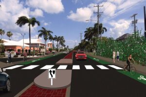
One plan for West Bay Road, considered under the previous government, involved removing the central turning lane and reconfiguring that road, along Seven Mile Beach, on a ‘complete streets’ model, including space for bikes, electric vehicles and other modes of transport. The one-way system around George Town could be expanded to similar effect.
From Howard’s perspective, building highways does not run counter to the goal of diversifying Cayman’s travel option, it facilitates it.
Two-way traffic
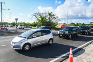
Aerial imagery of the morning rush hour aptly illustrates another side of the problem.
In one direction, vehicles are backed up bumper-to-bumper for miles on end. In the other direction, there’s nothing.
“You could land a small plane,” said Thibeault. “So, what if we rebalanced the load?”
One of the justifications for the road is that it will open up development opportunities for businesses to go east. In tandem with Plan Cayman, the long-awaited update to the Development Plan – it could create opportunities for people to work outside of George Town, Camana Bay and the traditional office spaces.
The reverse strategy to adding roads is to cut down on journeys and Thibeault believes that planning mixed-use communities and developing genuine job opportunities in the eastern districts could help do that.
Environmental concerns
The argument that the road opens up development opportunities is a double-edged sword.
The fact that the gazetted route of the East-West Arterial goes through the Central Mangrove Wetlands is a point of serious contention.
The Department of Environment has questioned the need for the road and warned that it could have a serious negative impact on the wetlands.
The Compass has reported on those concerns previously and will take a deeper look at the impact of the road on the natural environment in a future article.
Howard said the road would be subject to an environmental impact assessment and could be designed in a way that would not negatively impact the wetlands. He said it was possible to find engineering solutions to many of the concerns raised.
In terms of what happens beyond the highway, he acknowledged that was not within the NRA’s remit. Considered zoning of the land parcels in that area to ensure sensible and proportionate development will likely be necessary, he acknowledged.
Thibeault said there is land that would be suitable for low-density affordable housing once better road access is in place, but Plan Cayman is considered crucial in controlling whatever development takes place.
Despite concerns that the road could negatively impact the wetlands, contributing to flooding and lessening Cayman’s storm resilience, he argues it could have the opposite effect.
He said a properly planned and engineered road would leave the wetlands intact and replace a low-lying, one-directional coastal route with a more robust centrally located highway, designed to modern standards, with climate resilience in mind.
Traffic equity
The EIA will also examine the socioeconomic impact of the road.
Thibeault points out that almost half of Cayman’s population lives east of Grand Harbour.
The majority of those people make the bulk of their daily commutes on one-lane roads, while those on the western side have access to more modern highway infrastructure.
He said the NRA’s data indicates that 30% of Cayman’s road network experienced unacceptable levels of service in 2018. That will have risen to 60% by 2026, disproportionately impacting the eastern districts with peak-level congestion periods extending to more than three hours.
Howard acknowledges there are costs to building the road, but he believes there is a cost to doing nothing as well.
“We fully support a multi-pronged approach,” he said.
Related Videos


Overpass/flyover at ALT and Hurley’s roundabouts and most of the traffic will flow freely.
These are the big bottlenecks.