
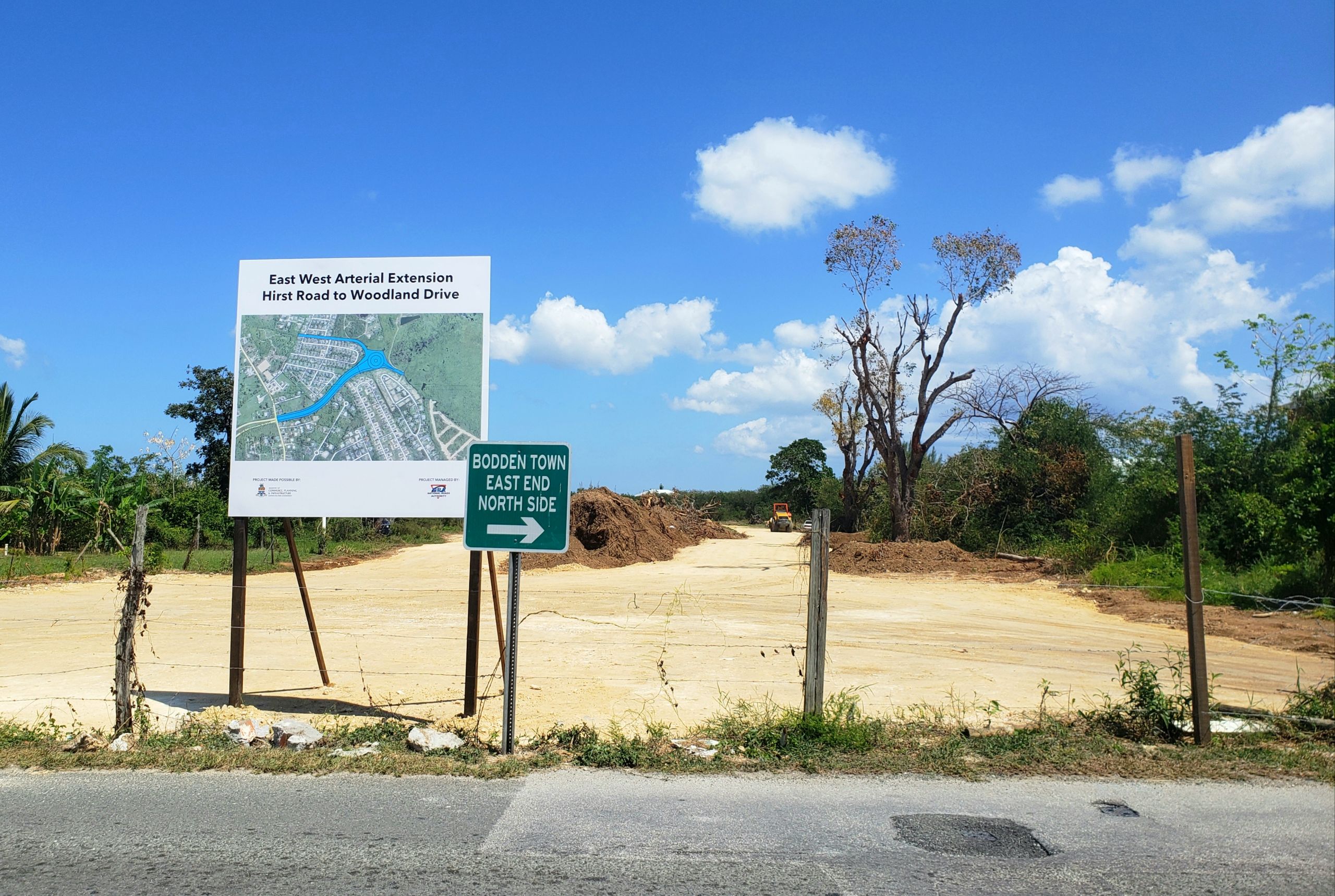
A draft document outlining the scope of an upcoming environment impact assessment for the expansion of the East-West Arterial road will examine not just its potential impact on the Central Mangrove Wetland, but also the consequences of not going ahead with the project.
The proposed road involves the construction of a 10-mile-long, 160-foot-wide, multi-lane-highway from Woodland Drive in Bodden Town to Frank Sound Road in North Side. Once completed, the East-West Arterial would connect George Town to North Side on a single highway.
In the document, the National Roads Authority says the proposed road will “create a highly disaster-resilient ‘central highway’; serve as an emergency route when coastal roads are compromised; reduce travel times between George Town and East End, North Side and Bodden Town; and promote public transportation (dedicated bus lines)”.

The National Conservation Council in 2016 determined that the road extension required an environmental impact assessment, as it will encroach on up to 174 acres of the Central Mangrove Wetland, “with the potential indirect disturbance of a larger area”.
The draft terms of reference, which will set out the parameters of the EIA, were published this week as part of a public consultation process that includes two public meetings which will be held next week.
The draft terms note that the EIA will cover, at least, the following areas:
• Route alignment and assessment of alternatives;
• Socio-economic considerations;
• Hydrology and drainage (including climate resiliency);
• Geo-environmental;
• Terrestrial ecology;
• Cultural and natural heritage sites;
• Greenhouse gas emissions; and
• Noise and vibration.
The terms of reference also specify that the EIA would need to assess the consequences of choosing not to build the road, which the NRA says is needed to address traffic congestion in the eastern districts.
Assessing impact on wetlands
The potential effect of the road on the Central Mangrove Wetland, and other important ecological sites such as the Mastic Trail, Meagre Bay Pond, and the Lower Valley and North South freshwater lenses, is the main reason for the EIA to be carried out.
The terms of reference note that the potential impacts from the project may include a change of water-circulation patterns, increase of stormwater runoff volume and velocity, decrease of water quality, and impact on the ecology of natural resources in those ecological sites as well as in nearby developed areas.
The EIA would look at the possible damming effect caused by the construction of the roadway changing water-circulation patterns, which could potentially restrict the movement of water to the Central Mangrove Wetland north of the proposed road, causing inundation of the mangroves and adjacent developed areas south of the proposed roadway.
The EIA would also examine possible impacts on groundwater and surface water flows, and drainage patterns that could affect both the Lower Valley and North Side freshwater lenses; as well as an increase of stormwater run-off volume and velocity from the road surface, which could increase flood risk.
The terms of reference also note that if the mangroves are chopped down and removed in the area, it would reduce protection from tropical storms and hurricanes, and could lead to a decrease in rainfall on the western end of the island.
It also points out, “The proposed roadway has the potential to release contaminants that may potentially pollute sensitive habitats and the underlying aquifers; and the potential negative impact on hydrology (movement of water) may impact the ecology of the Central Mangrove Wetlands, the Mastic Reserve, and the Meagre Bay Pond Protected Area.”
But it added that mitigation measures will be assessed that avoid or minimise such impacts and protect residents and natural resources.
Looking at alternatives
The document states that the EIA will assess three possible alternatives to building the road. These include a “no-build” option, which would be modelled to estimate future traffic conditions expected on affected existing roads if the extension is not constructed; and a “build in gazetted corridor option”, which would include changing existing roadway locations and layouts, such as using bridge structures to elevate roadways.
The third alternative the document looks at is changes to Bodden Town Road, such as imposing limited rights-of-way, creating dedicated lanes for public transit and pedestrian/bicycle use, and adding or widening lanes on existing roads, which may create a need to acquire property resulting in the relocation of residential or commercial buildings.
The EIA, according to the draft terms of reference, would explore the direct impact of the road, if it is built, on the area, as well as potential future “indirect” effects, such as the growth in the number of residential or commercial properties due to the improved access provided by the new roadway and/or reduced commute times.
It said such growth in developments is typically anticipated within about one mile of each new access point, excluding protected areas. The EIA would examine this element, as well as the effect of increased traffic associated with any new developments.
Next steps
Once the EIA is completed, an environmental statement will be drawn up to summarise the results of the assessment. This will act as a guidance document to provide decision-makers with any necessary information and the technical studies regarding the potential environmental effects of the project.
This environmental statement, like the draft terms of reference, will be subject to public consultation.
Members of the public can submit comments to the Environmental Assessment Board, via the Department of Environment, by email, direct mail or hand delivery to the DoE offices. These comments will then be jointly evaluated by the EIA consultants and the assessment board, and any relevant changes will be incorporated into the final documents.
Using the results of the EIA, an environmental management plan will be developed to establish the basis and plan for environmental monitoring and mitigation during the project.
Members of the public are invited to attend next week’s public meetings.
The first will be held at the Craddock Ebanks Civic Centre, at 923 North Side Road, North Side, from 6pm to 9pm on Tuesday, 7 Feb., and the second will be at the church hall of the Cayman Islands Baptist Church, at 163 Pedro Castle Road, Savannah, from 6pm to 9pm on Thursday, 9 Feb.
Representatives from the National Roads Authority and their EIA consulting team will be in attendance to provide information about the project, and answer questions from the audience.
The public consultation on the draft terms of reference will close on Monday, 20 Feb.
Read the draft terms of reference here.
For more details, visit the National Conservation Council website.
Related Videos


Excellent news. But a chain is as weak as its weakest link.
The weak links here are the Hurley’s and AL Thompson roundabouts. Unless flyovers (overpasses) are installed all this will do is create bigger traffic jams at these two choke-points.
I am curious as why I have her to hear any mention of building an elevated bridge type structure over the wetlands? While still going through the Westland it would at least minimize the impact of filling in road fill and changing the landscape. This has been done all over the world to preserve wildlife and such sensitive areas while still allowing infrastructure to be built? Sure seems like they are missing a pretty straightforward solution. Unless I’m missing something?
The article mentions “Looking at Alternatives”
…and a “build in gazetted corridor option”, which would include changing existing roadway locations and layouts, such as using bridge structures to elevate roadways.”