For the latest information on storm activity in the Cayman Islands, as well as information on how to prepare for hurricane season, visit Storm Centre.
Update: 4:30pm, 30 June: Forecasters are describing Hurricane Beryl as a “potentially catastrophic” storm as it barrels towards St. Vincent and the Grenadines and Grenada.
In its latest update, the US National Hurricane Center said the storm is expected to bring “life-threatening winds and sea surge” as it approaches the Windward Islands early tomorrow morning.
As of 4pm, Beryl was located 350 miles east-southeast of St. Vincent and 250 miles southeast of Barbados, travelling west-northwest at 18 miles per hour. Its maximum sustained winds are currently at 130 mph.
Hurricane-force winds are extending outward up to 30 miles from the centre and tropical-storm-force winds are extending outward up to 115 miles, according to the US National Hurricane Center.
The NHC forecasters noted that, after rapidly strengthening over two consecutive days, Beryl’s intensity appears to have levelled off.
However, they noted that fluctuations in strength are common in major hurricanes in conducive environments, and it is expected that Beryl will also fluctuate in strength for the next day or so.
“There is high confidence that Beryl will remain an extremely dangerous hurricane through landfall in the Windward Islands,” the forecasters said. “As the hurricane tracks across the Caribbean Sea, there likely will be a gradual increase in wind shear, which should induce a slow weakening trend.
“However, it should be emphasized that Beryl is forecast to remain a significant hurricane during its entire trek across the Caribbean region.”
Hurricane Hunter planes from the US National Oceanic and Atmospheric Administration and the US Air Force are scheduled to investigate the storm again later this evening.
This is the strongest hurricane on record to have developed in the month of June.
Update: 12pm, 30 June: Hurricane Beryl has been upgraded to a Category 4 storm after a US National Oceanic and Atmospheric Administration reconnaissance aircraft found the system had strengthened further on Sunday.
In its updated advisory, the Miami-based National Hurricane Center said that life-threatening winds and storm surge are expected in the Windward Islands beginning early Monday morning.
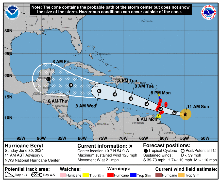
The NHC said that NOAA and US Air Force Reserve Hurricane Hunter aircraft data has indicated that Beryl’s maximum sustained winds are now estimated to be 130 miles per hour with higher gusts.
The hurricane was last located about 350 miles east-southeast of Barbados and about 460 miles east of Grenada.
It is moving west at 21 mph.
At present, this system poses no immediate threat to the Cayman Islands; however, Hazard Management Cayman Islands has asked the community to note that the forecast cone covers the Cayman Islands.
“Residents are encouraged to remain vigilant and stay updated with the latest weather developments,” Hazard Management said in its latest weather update.
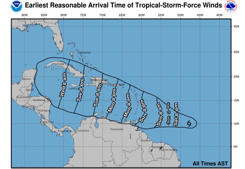
Update: 9:30am, 30 June: Hurricane Beryl strengthened to a Category 3 storm overnight, as it churned towards southeastern Caribbean islands.
According to the US National Hurricane Center, as of 7am Cayman time, Beryl was located 420 miles east-southeast of Barbados, and was moving westward at 21 miles per hour.
Maximum sustained winds at that time were 115 miles per hour.
Hurricane warnings and watches have been issued in Barbados, St. Lucia, St. Vincent and the Grenadines, Grenada and Tobago.
National Hurricane Center forecasters say a continued quick westward to west-northwestward motion is expected during the next few days.
On its current forecast track, the centre of Beryl is expected to develop into a “very dangerous” Category 4 storm before it moves across the Windward Islands early on Monday and across the southeastern Caribbean Sea Monday night and Tuesday.
The NHC forecasters noted, “Once Beryl enters the Caribbean, increasing shear will likely cause the hurricane to level off in intensity, then weaken through midweek.”
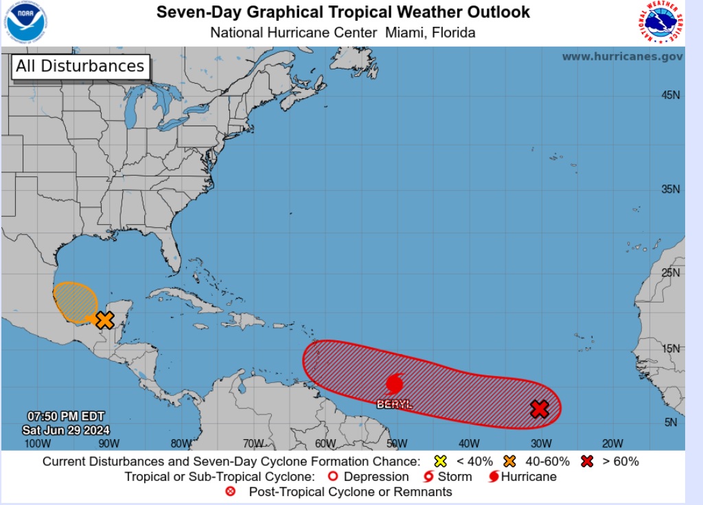
Beryl is being followed by an area of low depression that could develop into a tropical depression by mid-week as it moves generally westward at 15-20 miles per hour across the eastern and central tropical Atlantic, according to the NHC.
Update: 8pm, 29 June: The Cayman Islands National Weather Service and Hazard Management are keeping a close eye on the development of Hurricane Beryl, which on Saturday evening was moving westward at 22 miles per hour.
According to the US National Hurricane Center, at 7pm Cayman time, the storm was located 660 miles east-southeast of Barbados, and had maximum sustained winds of 80 mph.
The tropical storm was upgraded to a hurricane – the first of this year’s season – on Saturday afternoon after it surpassed wind speeds of 75 mph.
By the time it reaches the Windward Islands, late Sunday night or early Monday, it is expected to be a “dangerous major hurricane”, NHC forecasters say.
They noted that hurricane-force winds were extending outward up to 10 miles from the storm’s centre, with tropical-storm-force winds extending outward up to 60 miles.
AccuWeather forecasters are predicting that Beryl could be a Category 3 storm – with sustained winds of 111 mph or more – as it passes west of the Windward Islands, and into the Caribbean.
On its current forecast track, which can change as the system continues its forward movement, models show Beryl moving slightly south of Haiti and the Dominican Republic, over Jamaica and the Cayman Islands, and towards the Yucatan Peninsula.
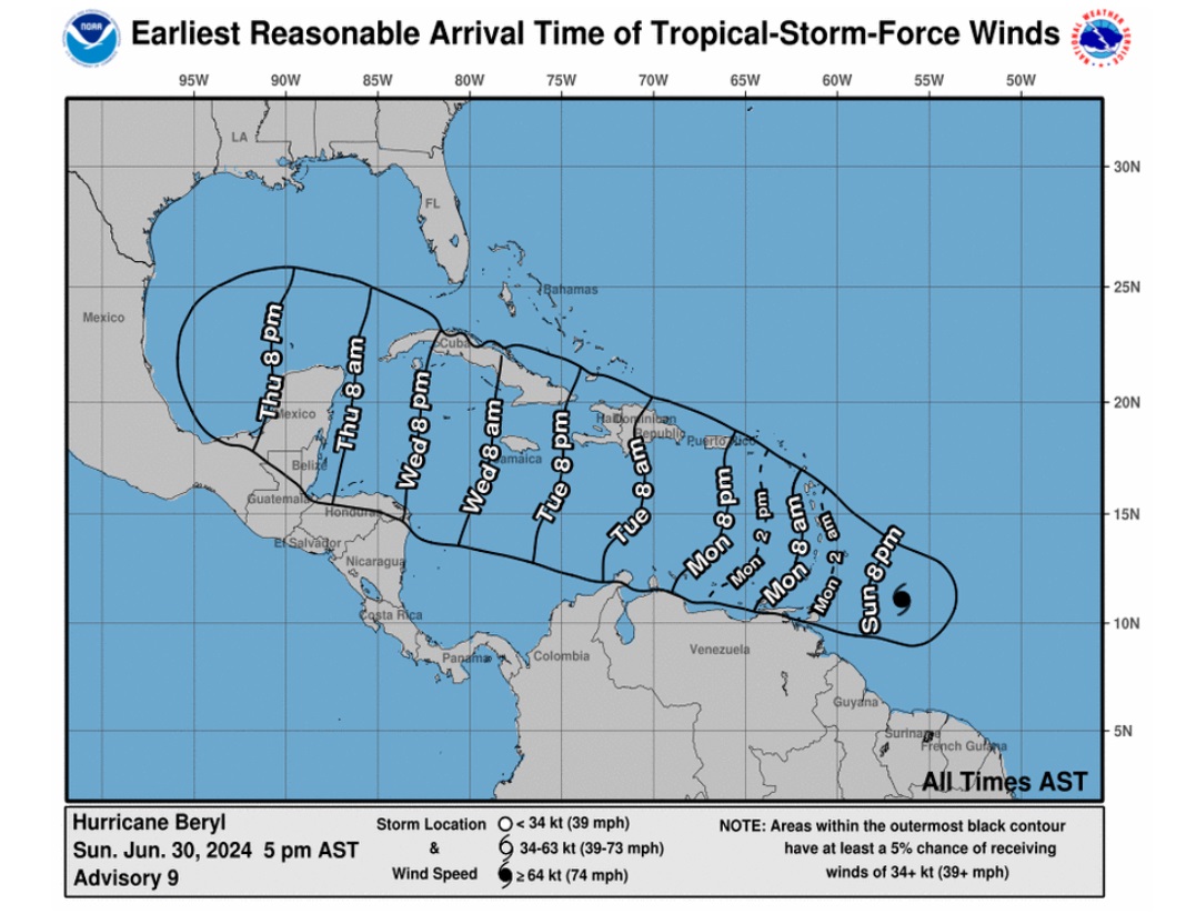
The Cayman Islands government, in a statement issued at 4pm, said, “At present, this system poses no immediate threat to the Cayman Islands; however, note that the forecast cone covers the Cayman Islands by Thursday morning.
“Residents are encouraged to remain vigilant and stay updated with the latest weather developments.”
Cayman’s stores were doing brisk business on Saturday, as residents collected hurricane supplies, stocking up on bottles water, batteries and other necessities.
Another disturbance, further east in the Atlantic, is also being monitored. This area of low pressure is expected to develop into a tropical depression by the middle of next week, according to NHC forecaster.
Update: 11:45am: Weather models are predicting Tropical Storm Beryl could impact Cayman by early Thursday.
The Cayman Islands Weather Service, in its afternoon forecast today, noted that the storm was located 820 miles east-southeast of Barbados as of 10am.
“At present, this system poses no immediate threat to the Cayman Islands; however, note that the forecast cone now covers the Cayman Islands by Thursday morning. Residents are encouraged to remain vigilant and stay updated with the latest weather developments,” the weather service stated.
The US National Hurricane Center, in its latest update, said Beryl is expected to develop into a “major storm” when it reaches the Windward Islands late Sunday night, but may slowly weaken thereafter.
It noted that the storm, which at 11am Saturday had sustained winds of 65 miles per hour, was strengthening at a quick pace, and was nearing hurricane-speed winds.
The National Hurricane Center said the environment will become “a little less conducive after Beryl moves into the Caribbean Sea, and some increase in shear will likely end its strengthening phase and cause slow weakening toward the end of the period”.
Tropical Storm Watches have been issued for Martinique and Tobago, while St. Lucia, St. Vincent, the Grenadine Islands and Grenada are currently under Hurricane Watch.
Original story: A tropical depression in the southeastern Atlantic has formed into Tropical Storm Beryl, the second named storm of this year’s hurricane season.
The storm is expected to strengthen into a hurricane by late Sunday night or Monday morning, bringing a risk of heavy rainfall, strong winds and dangerous storm surge and waves, according to the latest report by the US National Hurricane Centre.
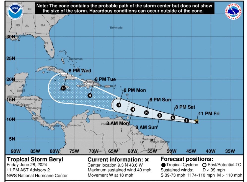
While the storm poses no immediate threat to Cayman, Hazard Management Cayman Islands and the Cayman Islands National Weather Service are urging the public to remain vigilant.
Most models suggest Beryl will enter the western Caribbean in mid-to-late next week.
A separate weather system of low pressure, located southwest of Grand Cayman, is currently bringing rainy conditions to the island.
“I would like to remind everyone to be prepared at all times during what’s predicted to be a very active hurricane season and to follow the official channels for accurate weather updates,” Hazard Management director Danielle Coleman said in a statement.
As of 11pm Friday, Tropical Storm Beryl was moving towards the west at almost 18 miles per hour. On the current forecast track, the system is expected to move across the Windward Islands late Sunday night and Monday. Maximum sustained winds had increased to nearly 40 mph, with higher gusts.
Related Videos


