The US government’s National Oceanic and Atmospheric Administration recently completed storm surge modelling maps of the Cayman Islands, and a beta version of the potentially life-saving resource is now available on the National Hurricane Center’s website.
A press release issued by the Cayman Islands government said, “This technological advancement promises to significantly enhance the Cayman Islands’ resilience to tropical storms and hurricanes by providing more precise and timely alerts.”
In addition to supporting improved forecasts, when a powerful hurricane threatens the Islands, the NOAA storm surge model could assist Cayman Islands Government with decisions relating to evacuation orders; an option available under the Disaster Preparedness and Hazard Management Act (2019 Revision), but which has rarely been used.
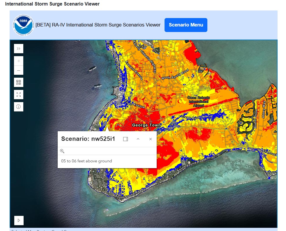
Hurricane Ivan brought an estimated 8- to 10-foot storm surge to parts of Grand Cayman in 2004, leading to significant property damage. Since then, the population has nearly doubled, from around 44,000 in 2004 to nearly 85,000 in 2023. With a larger number of people living on or near Grand Cayman’s coasts, storm surge and waves in hurricanes and tropical storms present a growing risk. The model produced by the National Hurricane Center utilised powerful computers, along with the high-resolution Lidar mapping imagery of land and inshore marine environment across Grand Cayman, Little Cayman and Cayman Brac, to determine how high the waves and the surge are expected to come up on the land in a storm, based on the many different scenarios of wind speed, angle of approach and tidal height.
“During the 2025 Atlantic hurricane season, CINWS meteorologists will evaluate its potential applications for improving storm surge forecasting and warning capabilities beyond current planning tools,” the government said in the release, adding, “Specialists within [Hazard Management Cayman Islands] will also use the tool to aid in risk mapping and supporting data driven decision making during inclement weather events.”
John Tibbetts, director general of the CINWS said, “Storm surge and flooding remain a critical risk of hurricanes and tropical storms in the Cayman Islands. Any advancement in prediction and warning technology has the potential to transform local weather forecasting.”
Shamal Clarke, CINWS Meteorologist said: “This is definitely exciting news and allows us to gain some insights into possible storm surge scenarios while we await access to the full version of the model.”
It is possible that the “full version of the model”, referred to by Cayman Islands National Weather Service Meteorologist Shamal Clarke, may also include additional forecasting tools that will only be available to trained meteorologists during the beta testing phase. This could include information relating to the size of the hurricane force wind field, which would enable the National Hurricane Center and the Cayman’s Weather Service to make even more precise forecasts of expected inundation levels during a hurricane. The size of the wind field can have a dramatic influence on the height of the surge.
Earlier in the year, there were concerns that the delivery of the hurricane storm surge and wave inundation model for the Cayman Islands and Jamaica might have been in jeopardy following efforts to cut costs by the Republican administration and the newly created Department of Government Efficiency in the United States. They were due to be completed by the US National Oceanographic and Atmospheric Administration in 2025,
According to the Wired news organisation, employees at NOAA had “received orders to pause all international engagements”. Scientific American was also reporting that as much as half the workforce at NOAA could be laid off.
However, in April Chief Meteorologist Kerry Powery had said the US National Hurricane Center in Florida continued to work on the storm surge and wave inundation model for the Cayman Islands and Jamaica.
Powery said, “Budget cuts at NOAA and the US National Weather Service may hinder the amount of effort they are able to put into producing the model, but they [NOAA representatives] said reasonably confidently that it will continue to be worked on.”
Hazard Management Cayman Islands welcomed the arrival of the surge model. Director Dani Coleman, said, “While we maintain our own robust hurricane monitoring and warning systems, international collaboration through programmes like the International Storm Surge Scenario Viewer has already enhanced our storm surge planning capabilities.”
The Storm Surge Scenario View can be found on the NOAA website at https://www.nhc.noaa.gov/surge/international/
Related Videos


