For the latest information on storm activity in the Cayman Islands, as well as information on how to prepare for hurricane season, visit Storm Centre.
Tropical Storm 25 has formed in the northwest Caribbean, prompting warnings and watches along the the Yucatan Peninsula.
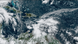
Rain and winds hit Grand Cayman Friday morning due to an area of low pressure just west of the Cayman area, according to the National Weather Service. Fresh southeasterly winds and rough seas along with scattered showers and thunder are expected across Cayman for the next 24 hours, the NWS said.
“Cloudy, rainy day likely today,” NWS director general John Tibbetts posted on social media Friday morning. “Although radar images indicate that most showers have moved west of the area.”
A weather warning has been issued for small craft and fishing vessels, the Port Authority of the Cayman Islands posted on social media.
The low pressure system is expected to continue to slowly drift northwest over the next few days. Radar images show scattered showers in and around the Cayman area moving towards the northwest.
The NWS says it’s monitoring TD 25.
The tropical depression is moving northwest at 9 miles per hour with maximum sustained winds of 34 miles per hour with gusts up to 46 miles per hour.
“Fresh to strong trades (winds) are expected over the eastern and central Caribbean through Sunday night,” according to the US-based National Hurricane Center. “Winds and seas will subside Monday and Tuesday across the basin.”
For the weekend, the NHC says the Cayman area can expect scattered showers and thunderstorms with east-southeasterly winds between 23 and 29 miles per hour on Saturday with those wind speeds decreasing Sunday.
The Storm is expected to strengthen into a tropical storm on Sunday, according to the NHC.
In Mexico, a tropical storm warning is in effect for Punta Herrero to Cabo Catoche. A tropical storm watch is in effect for areas south of PUnta Herrero to Puerto Costa Maya and west of CAbo Catoche to Dzilam.
No other country has issued a watch or warning in connection with this system.
Further east, a tropical wave over the eastern Caribbean is producing a large area of disorganised showers and thunderstorms along with locally heavy rainfall and gusty winds, according to the NHC.
This wave is forecast to move westward at 15 to 20 miles per hour and has a 30 percent chance of development over the next five days, according to the NHC.
Related Videos


