
For the latest information on storm activity in the Cayman Islands, as well as information on how to prepare for hurricane season, visit Storm Centre.
Update: 10:30pm: Hurricane Eta continued to strengthen on Monday night as it moved towards the coast of Nicaragua, and could become a Category 5 storm by Tuesday, the US National Hurricane Center reported.
Describing the storm as “dangerous”, the NHC said that by 10pm, Eta’s winds had increased to 150 miles per hour, from 130 mph on Monday afternoon.
The storm could become a Category 5 hurricane, with winds of at least 156 mph, by the time it makes landfall Tuesday, the NHC stated.
In Cayman, local forecasters told the public to expect an increase of showers, winds and rough seas overnight. A small-marine-craft warning remains is in effect.
The NHC, in its 10pm bulletin, said an Air Force Reserve Hurricane Hunter aircraft had found that the storm was strengthening rapidly as it approached the northeastern coast of Nicaragua at about 7 mph.
Hurricane-force winds were extending outward up to 25 miles from the centre and tropical-storm-force winds were extending outward up to 125 miles, the Hurricane Hunter found.
On its forecast track toward the west-southwest, the NHC said the centre of the storm is expected to make landfall in Nicaragua early Tuesday, bringing life-threatening storm surges, catastrophic winds, flash flooding and landslides.
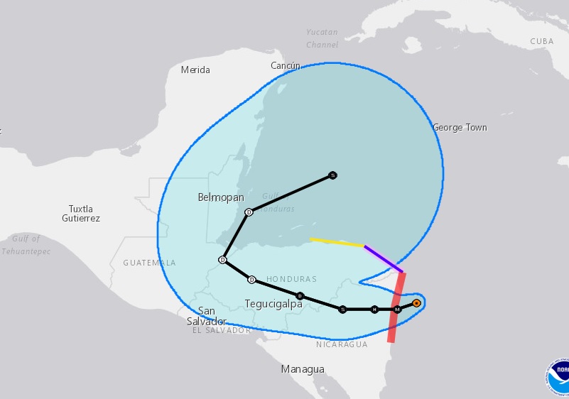
At 10pm, it was located 45 miles east of Puerto Cabezas in Nicaragua.
The storm is expected to deliver heavy rainfall of between 15 and 25 inches, with isolated amounts up to 35 inches in Nicaragua and Honduras.
The NHC reported that a dangerous storm surge will raise water levels by as much as 14 to 21 feet above normal tide levels along the coast of Nicaragua.
Original story: Hurricane Eta has been upgraded to a Category 4 storm, with winds of up to 130 miles per hour.
The storm, at 1pm, was located 319 miles south of Grand Cayman, and was moving west-southwest at almost 9 mph.
Cayman’s National Weather Service reported that the Cayman Islands can expect increased showers, high winds and rough seas from later today. A small-craft warning is in effect for Grand Cayman, as strong east-to-northeast winds and seas with wave heights of 7 to 9 feet, with higher swells especially on the east and southerly coast, are forecast tonight.
Radar images show scattered showers in and around the Cayman area, which are moving towards the west to southwest.
Hurricane Eta is expected to make landfall along the coast of Nicaragua tonight or early Tuesday, the National Hurricane Center in Miami, Florida, reported in its 4pm update.
The centre of Eta is forecast to move inland over northern Nicaragua through Wednesday night, and then move across central portions of Honduras on Thursday.
Additional strengthening of the storm is expected as Eta reaches the Nicaraguan coast. The National Hurricane Center said the storm is likely to bring “life-threatening storm surge, catastrophic winds, flash flooding and landslides” across portions of Central America.
Hurricane or tropical storm warnings are in effect for sections of the Nicaraguan and Honduran coasts.
Related Videos


