")
The long-awaited East-West Arterial extension is moving to the next phase as the National Roads Authority invited bids from firms to conduct an environmental impact assessment for the project.
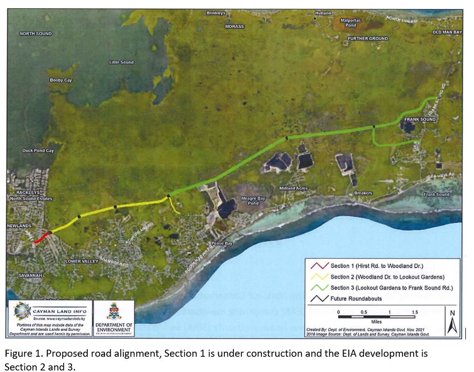
The NRA, according to a request for proposals posted on the government procurement Bonfire portal on Friday, is seeking a qualified environmental firm to perform the EIA for the extension, from Woodland Drive to Frank Sound Road (sections 2 and 3 of the East-West Arterial – see image below).
Last month, NRA managing director Edward Howard announced that the project was moving to the next stage as he addressed a Prospect constituency meeting organised by Prospect MP and Health Minister Sabrina Turner.
The request for proposals, the NRA said through its tender, has been issued to select one professional environmental consultant to perform all requisite technical studies and analyses to complete an EIA for the extension.
The bidding exercise will be open until 5pm on 14 April 2022.
Issues to be considered
The scoping opinion for the EIA for the project, dated November 2021, which aims to provide much-needed traffic-congestion relief for the eastern districts, was carried out by the Environmental Assessment Board – a subcommittee of the National Conservation Council chaired by Department of Environment Director Gina Ebanks-Petrie.
Back in 2016, the National Conservation Council required an EIA for the proposed 10-mile-long road as it would “traverse a substantial area of wetland habitat along the entire length of the southern perimeter of the Central Mangrove Wetland.
“As the ecological heart of Grand Cayman, the wetland is critical to many important natural processes which are vital to the long-term wellbeing of the residents of the Cayman Islands,” it had stated.
According to the scoping opinion, the NRA, as project proponent, is proposing the construction of a 160-foot-wide, multi-lane highway from Woodland Drive to Frank Sound Road.
At its eastern end, the proposed route includes an 80-foot-wide southern connector road.
“The footprint of the proposed road will result in the removal of 174 acres of undisturbed terrestrial habitat,” it added.
The EIA will look at the route alignment and assessment of alternatives.
A key objective of the EIA, the scoping opinion said, is to ensure that the selected road design offers the best outcome for the environment as well as for surrounding communities, saying the assessment shall “appropriately assess and compare the environmental effects of relevant options for routes, engineering techniques, mitigation, construction management and operational management”.
The terms of reference, the scoping opinion said, shall set out what options for the corridor have been considered to date and which is the preferred choice, outlining the reasons for its selection.
The assessment will also look at the environmental impacts of the road, for which the scoping opinion states “there are likely to be significant environmental effects in the following key areas: Hydrology and Drainage; Terrestrial Ecology (Wetlands); Terrestrial Ecology (Mastic Reserve); Cultural and Natural Heritage; and Greenhouse Gas Emissions”.
The scoping opinion also suggested that socio-economic considerations, including the “need” and rationale for the road, should have been taken into account by way of a strategic environmental assessment prior to the gazettal of the road corridor.
“Unfortunately, the utility of an assessment of the ‘need’ for the road extension and its socioeconomic impacts will be of limited value now given that the corridor has been gazetted since 2005 and development applications subsequently approved along parts of the route have, to a degree, fixed its alignment,” it said.
Changes to route suggested
The scoping opinion said the Environmental Assessment Board consulted with the National Trust given the severing of Trust lands, including the Mastic Reserve, by the proposed route.
A meeting was held on 1 Nov. 2021 with the director of the National Trust and members of the Trust’s Environmental Advisory Committee (EAC).
“EAC members expressed their concerns regarding the alignment of the eastern end of the route and its likely major significant negative effects on the Mastic Reserve, both in terms of its ecology and visitor experience. The current alignment severs the Trail head from the remainder of the forest, requiring visitors to the Reserve to cross a multi-lane highway,” it stated.
The National Trust recommended the road should be moved south in order to ensure it does not traverse Trust-owned properties in the Central Mangrove Wetland; and the proposed roundabout repositioned to a “more ideal location” along the red line on the map, thereby avoiding the Mastic Trail and Reserve.
The proposed road acts as a physical barrier between the higher and lower elevations, and could act as a dam.
It said the Central Mangrove Wetland could be deprived of water and “there may be ecological consequences”.
By changing the balance and patterns of water movement, there could be significant adverse effects on both residential populations and the Central Mangrove Wetland, and an EIA is required to investigate those impacts so that they can be appropriately avoided, minimised or mitigated.
It also said the EIA needs to ensure that climate change resilience is built into the road design.
Next steps for project
The next stage of the process, following completion of the tenders, is for the NRA to provide the Environmental Assessment Board with details of up-to-three suitably qualified consultancy firms to carry out the EIA based upon the requirements outlined in the scoping opinion.
The EAB will then review submissions, confirm the bidders have the necessary expertise and select a consultant(s) to undertake the project, the scoping opinion stated.
The Environmental Assessment Board will then meet with the NRA and its environmental impact assessment consultancy team to discuss the development of the draft terms of reference for the EIA, based on the scoping opinion.
The draft terms of reference will then head to public consultation, including discussion in at least one public meeting, for a period of 21 consecutive days. It will be finalised, once the public input is taken into account.
Related Videos


The East-West Arterial road activity is too little, too late. More expensive and slow “consultants” – I cannot understand what has taken NRA managing director Edward Howard so long to even get out an Environmental Impact Assessment consultancy bid! It has taken years. And who knows how long the consultants are going to say they need to perform a study that should have started two years back. And if a new bus system is introduced, who will ride a bus from East End when they know that due to NRA sloth the traffic will be such that the bus time of arrival into Georgetown cannot be predicted? Has anyone given thought to a monorail in the centre of the East-West highway? That would not be affected by traffic and would be less expensive than maintaining a fleet of buses. But that would take another 10 years of indecision…
Well, Mr. F.S, I have travelled all over the world and seen mangrove buffers in many countries. Believe it or not, they WORK!! The Asian tsunami of 2004 is a classic case. The villages and resorts that had cleared their mangroves for an “:ocean view” were totally destroyed. Those which had kept the mangrove buffers were well protected. Concrete did not survive.
The “80 foot wide southern connector road” joins Frank Sound Road a couple of miles from the main connection. Why? Run that road straight south and join Bodden Town Road and now you have actually helped a bunch of people reduce their drive time – all those in the Breakers area will have a substantially shorter drive. This is only slightly more road to be built.
The only people that will use any form of public transport are those who do not own a car. If 2500 people that own a car need to travel each day from East to West, you will have 2500 cars on the road, even car pooling is virtually non-existent. People demand their independence from anyone else to move around, been like this ever since I came here 38 years ago and no public transport system is ever going to change that.
Changing the legal age to drive may put a dent in the amount of cars on the road from 16 to 18 or even 21 years old like other countries have done.
Demanding all school kids must use the school bus system will keep a few cars off the road in the morning particularly with all those parents dropping off or collecting one kid at school 5 days a week.
Floating shifts work pretty good wherever possible.
These few thoughts may alleviate the need for 160 feet wide roads a bit which will all eventually bottleneck anyway unless we revamp the entire road system. These types of roads will only increase the road rage speed a lot of people will apply………..