
On Wednesday, 1 June, residents across Cayman, the wider Caribbean, US, and South and Central America must start the annual six-month watch in anxious anticipation brought on by the uncertainty of the Atlantic hurricane season.
If predictions hold true, the Atlantic basin will see another above-average hurricane season for the seventh consecutive year.
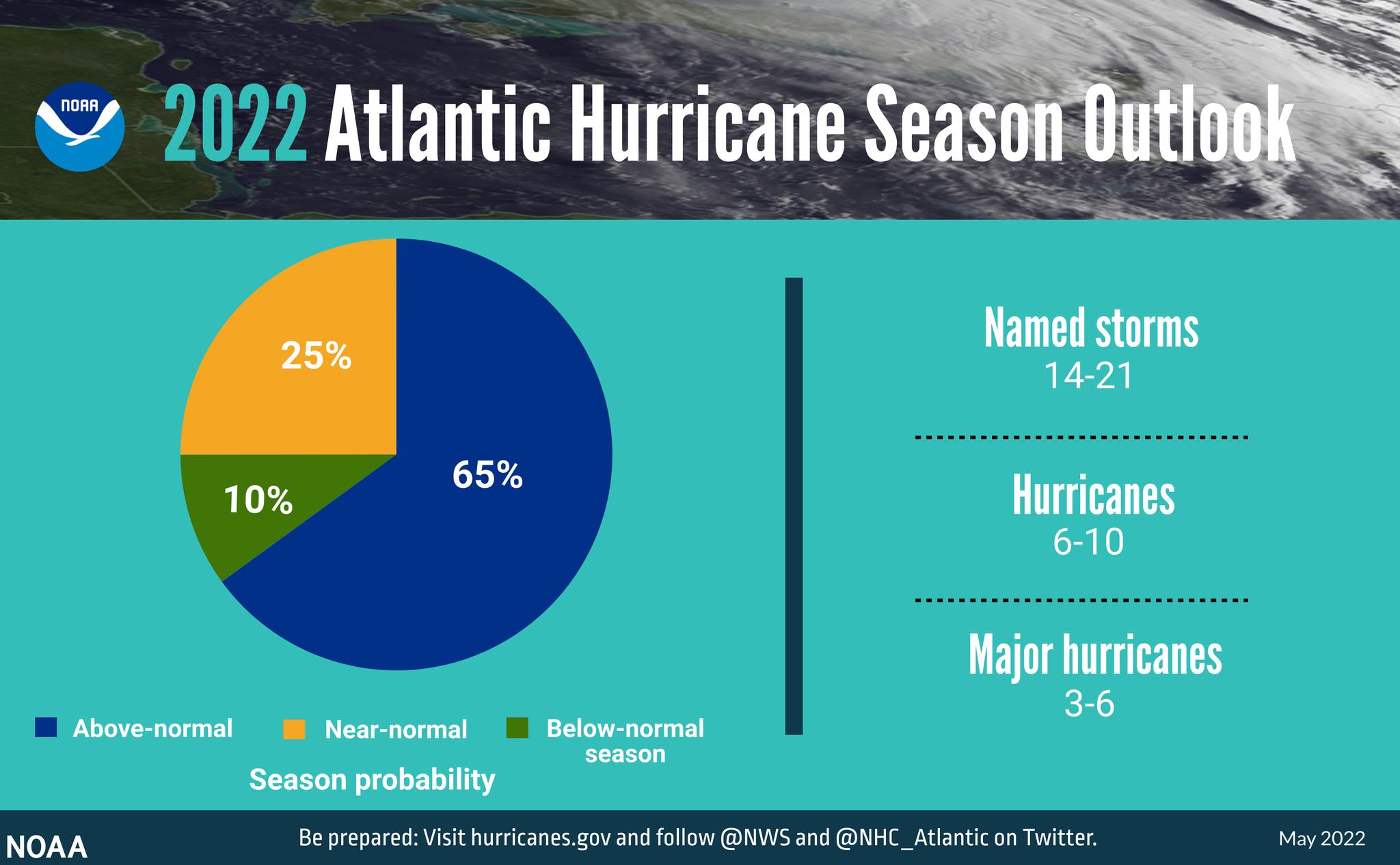
An initial forecast from the National Hurricane Center in Miami, Florida, suggests as many as 21 tropical storms could develop during the upcoming six-month season.
While half of those storms are expected to bring minor flooding with a few strong gusts of wind, the other half are predicted to develop into potentially catastrophic cyclones.
‘The 800-pound gorilla in the room’
What is exceptional about the 2022 Atlantic hurricane season is the re-emergence of a warmer-than-usual loop current which has extended further north into the Gulf of Mexico than it usually does and is currently churning deep columns of warm water to the surface.
The loop current refers to the movement of water along a generally diagonal line from the north-eastern edge of the Yucatan Peninsula towards Cuba. The current fluctuates on a six-to-11-month basis, during which it either extends north into the Gulf of Mexico or contracts into the sub-tropical region.

“What is interesting about this year’s loop current is that it is shaping up a lot like it did in 2005, the year of Hurricane Katrina,” said Nick Shay, a professor of oceanography at the University of Miami, Florida.
Shay told the Cayman Compass he first became aware of the loop current back in 1979 after an encounter with intense Hurricane Frederick, while working as a research officer with the US Navy.
In an article published by Shay, which has since been referenced significantly by the US National Oceanic and Atmospheric Administration, he described the loop current as the “800-pound gorilla in the room, that we need to talk about”.
“It has the ability to fuel the rapid development and intensification of monster storms,” he said.
According to Shay, satellite imagery and sea temperature recording equipment indicate that this year’s loop current has extended well past the northern latitudinal point of 28 degrees, into the Gulf of Mexico, which is nearly double the typical 10 to 15-degree limit.
When the warmer water from the loop current mixes with cooler water from the northern Gulf of Mexico, Shay said, there is significant heat transfer, causing the colder water to heat up.
“The result of this is that these storms which require warm water to develop into monster hurricanes are able to rapidly intensify as it gets closer and closer to making landfall,” he said.
Shay said the warmer water being channelled by the loop current is being fuelled by the subtropic conditions where the water is even hotter.
“The concept remains the same for the Cayman Islands, and the rest of the Caribbean, because what we are seeing is that, when predicting the storms, there needs to be joint consideration between oceanic and atmospheric conditions,” he said.

Season outlook
On 24 May, NOAA issued its predictions for the upcoming Atlantic hurricane season.
“For the range of storms expected, NOAA calls for a 70% probability of the following ranges; 14 to 21 named storms with top winds of at least 39 miles per hour, of these, six to 10 will become hurricanes with top winds of at least 74 miles per hour, and of these three to six major hurricanes ranked as Category 3, 4, or 5 with top winds of at least 111 miles per hour,” said NOAA administrator Richard Spinrad.
The average hurricane season calls for 14 named storms and seven hurricanes, three of which are major. It is calculated using a 30-year period of storm activity which spans from 1991 to 2020.
NOAA’s predictions are roughly in line with that of the Colorado State University’s Tropical Meteorology Project, which also called for an above-average hurricane season.
In its April forecast, CSU predicted 19 named storms and nine hurricanes four of which they said are likely to strengthen into major hurricanes.
Not all bad news
Although the outlook for the 2022 Atlantic hurricane season may seem gloomy, it’s not all bad news.
This year will see an end to a seven-year streak of pre-season storms, as forecasters say no developments are expected ahead of the season’s 1 June start.
On 26 May, with only five days until the official start, forecasters at the NHC updated their Graphic Tropical Weather Outlook to read, “No new tropical cyclones are expected during the next five days.”
For the latest information on storm activity in the Cayman Islands, as well as information on how to prepare for hurricane season, visit the ALT Storm Centre.
Related Videos


