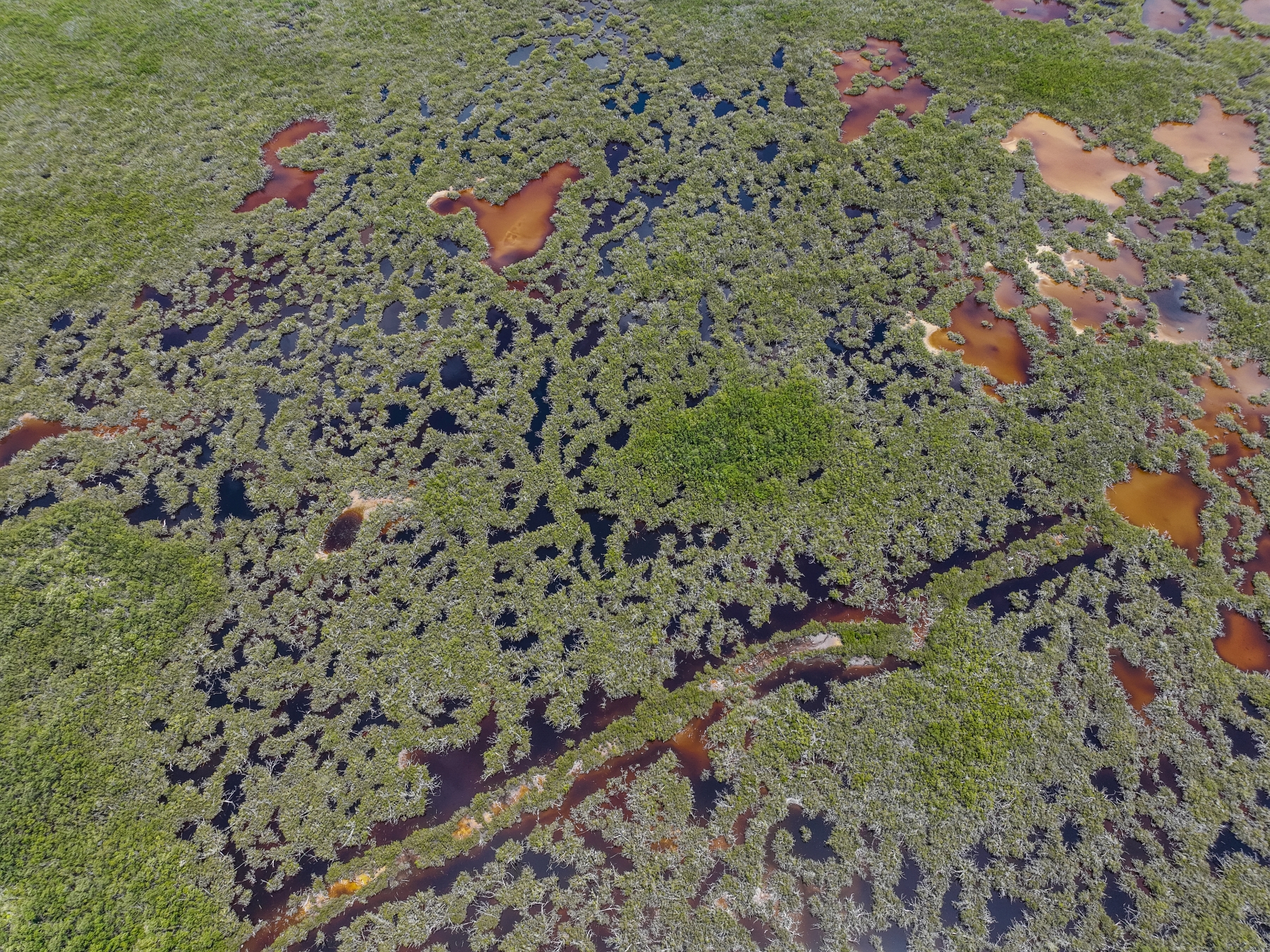
Across the eastern districts, an unbroken canopy of verdant green stretches across thousands of acres of forest and mangrove wetlands to the shimmering sea beyond.
This is Grand Cayman’s last wilderness and the ecological heartland of the island.
Stunning drone footage, recorded for the Cayman Compass, shows the path that the extended East-West Arterial Highway will cut through this previously untouched landscape.
The potential impacts span far beyond the limits of the four-lane road, which itself is expected to consume almost 200 acres.
For better or worse, property experts and government officials acknowledge it will unlock economic potential of land that was previously undevelopable.
In a best-case scenario, proponents of the road argue it could allow for new affordable housing projects in areas where land is cheaper and stimulate opportunities for businesses to move east.
The aim, says the National Roads Authority, is to cut journey times and unlock the potential for development in the interior of the country.
But while the road itself, which bisects the Central Mangrove Wetlands, will be subject to a comprehensive environmental impact assessment, the NRA acknowledges it has little control over how and what construction takes place on the adjacent land.
The worst-case scenario, environment officials and activists believe, is that the road stimulates a slew of uncoordinated development, spiralling beyond its perimeter.
If past is precedent, the Department of Environment warns, the land will quickly become criss-crossed with a spiders-web of side roads and sub-divisions as landowners maximise the economic value of their lots.
Road a priority for government
While questions remain about the legitimacy of the highway as a valid modern solution to Cayman’s well documented traffic problems, there is an acceptance that something must be done about congestion and a growing sense that the long-planned project – earmarked as a priority by the PACT government – is going to happen.
Data from the NRA shows commutes from North Side to George Town will average around two hours in little over a decade without action.
The EIA – if carried out properly and followed faithfully – should ensure the ecological integrity of the mangrove wetlands – a vital flood plane and storm barrier for the entire island. But the capacity to limit the damage from knock-on development, is a larger and as-yet unaddressed concern.
Much of the land in the area is zoned for farmland or low-density residential development.
Owners of lots along the route include the Dart group and internet entrepreneur Frank Schilling.
There is no process, beyond the Development Plan, which is still a work in progress, for the road to be combined with any co-ordinated approach to land use impacts.
Sustainable Cayman has called for a ban on development to the north of the route, where some of the most ecologically important land remains. But there is currently nothing to stop a landowner from applying to build anywhere along the corridor – including in the wetlands.
And while the principle of ‘eminent domain’ can be used to force landowners to sell property for road development, the same principle does not apply to land for preservation.
The National Trust and government can, and do, buy up parcels for protection but it requires significant funds and a willing seller. And once the road goes in the cost of property is only going in one direction.
The current plan

The road corridor, which would expand the East-West Arterial Highway, from its current terminus at Hirst Road in Savannah to Frank Sound, was first gazetted in 2005 and has been on a wish list of national infrastructure projects of successive governments for some time.
Premier Wayne Panton has indicated his government’s intention to get the job done.
While the project may seem to conflict with Panton’s stated priorities of sustainability and environmental protection, he has argued that the highway is part of a long overdue upgrade to the island’s road network.
The National Roads Authority has also reframed the debate around climate resilience, arguing that the low-lying coastal road that provides the only current route to the east could easily be cut-off in a hurricane. The new route it says will offer a “disaster resilient” central highway.
The authority is currently in the process of finalising its recommendation for a contractor to carry out an environmental impact assessment following an open bid process.
If and when that assessment has taken place, the next step would be for government to publish notices alerting land owners and for the Lands and Survey department to begin the process of buying up lots along the route through a series of compulsory purchase orders.
Speaking to the Compass earlier this year NRA managing director Ed Howard said he was confident the road could be designed in a way that was sensitive to the surrounding environment and ensured the integrity of the Central Mangrove Wetlands.
He said the authority, however, didn’t control what happened outside the parameters of the road corridor.
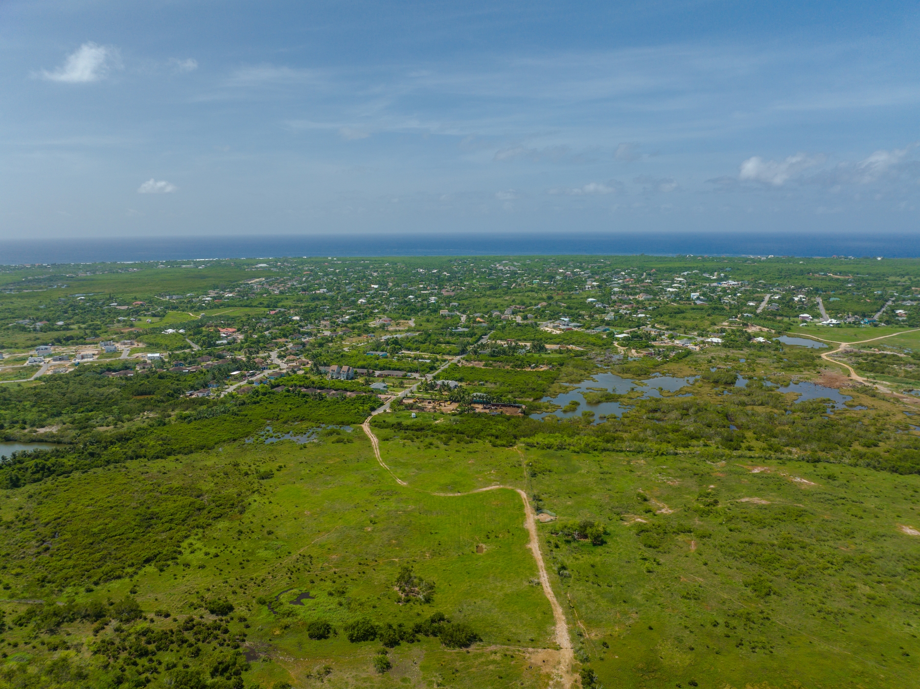
Housing follows highways
Uche Obi, chief valuation officer at Lands and Survey, said there was no sign of any significant recent property speculation along the road corridor.
He said it was possible that this type of investment may occur once the plans for the road are further along and developers begin to gauge the possibilities.
Rick Riyatt, a senior valuation surveyor with BCQS, said it was likely that land values would rise as plots become “unlocked”.
Obi believes the eventual development of the land adjacent to the road is inevitable.
“Once the road comes in the land will likely be subdivided and there will be building that takes place,” he said.
“The road is definitely going to have an impact on adjacent parcels.”
Obi’s department is responsible for compensating property owners whose land is taken for the highway.
But, because previously inaccessible land will now be commercially marketable, for many of those owners, delivering road access will raise the value of their remaining plots to such an extent that government will not owe them a cent.
Obi said the pattern of previous road developments had shown that where highways go, housing soon follows.
Aerial images from the Lands and Survey Department show that wherever highways have been built in Cayman, housing has soon followed.
You can use the interactive slider on the images below to see how building cropped up around two such projects in Cayman since 2004.
Hurley Merren Boulevard
Rex Crighton Boulevard from Red Bay to Poindexter Road
“These schemes have definitely had a positive impact on the value of adjoining land parcels as they have opened up landlocked parcels which would not have been developable without the access roads,” Obi added.
Not everyone sees that as a bad thing.
Speaking to the Compass earlier this year, Denis Thibeault, assistant director of the NRA’s transportation and planning unit, suggested the road could help facilitate affordable housing, particularly in Lower Valley and Beach Bay.
“The eastern districts are the only place a small Caymanian family can afford to buy. Surely they can’t afford to buy in South Sound where a small 1,600-foot condo with no yard costs $430,000,” he added.
The NRA believes it will also help create the possibility for mixed-use communities in the east and allow more people to work in that part of the island.
Frank Schilling, who owns a 613 acre parcel close to Norhtward believes it would be a good plot for a sub-division. He has no current plans to develop the land himself, however, and is looking to sell his holdings in the area. He bought the property with the initial intention of landing a telecoms cable – a project he has since abandoned, with government taking the lead on a similar initiative.
He said there are significant portions of land, particularly on the section of the road corridor between Hirst Road and Bodden Town that would be suitable for development and could provide answers to Cayman’s affordable housing issues. He believes the wetlands should be protected in perpetuity, however.
The planning department was not available to answer questions on whether the road will be accompanied by any process to ensure that this happens. Plan Cayman, which has been in progress for several years, seeks to address some of those issues on a national level.
Obi said the most reliable way to protect land for conservation would be for government or the National Trust, which already owns large parcels in the area, to buy it.
A new frontier
The Department of Environment’s concerns about the road corridor itself are well documented and articulated in a ‘scoping opinion’ for the environmental impact assessment.
Officials now have a degree of comfort now among environment officials that a process will at least be followed to minimise the road’s impact on the wetlands.
But “significant concerns” remain that it will open up a new frontier for development.
“Almost everything to the north of the road consists of primary habitat,” said DoE director Gina Ebanks-Petrie. As well as the central mangrove wetlands, there are areas of dry forests and shrub land.
Some of it has remained untouched for thousands of years.
In the absence of an updated development plan, Ebanks-Petrie said the people of Cayman had not had an opportunity to articulate or control how they want the eastern districts to develop.
It is logical, she fears, that the growth in the east will, by default, follow a similar pattern to what has occurred on the west side of the island, where the scale and density of development has wiped out 70% of the mangroves in the last four decades.
She acknowledged some affordable housing development in the area could be beneficial for the islands as a whole, but, without a co-ordinated plan, she questions why landowners won’t simply maximise the value of their parcels as they have done elsewhere.
Do highways reduce congestion?
There are questions, too, over whether the road could even add to the problems it is designed to fix.
Sustainable Cayman would like to see a more co-ordinated transport strategy developed before it is built. The environmental pressure group told the Compass it is not “too late” for government to reverse its decision to go ahead with the highway and instead focus on development planning and public transport strategies that allow people to live, work and play in the districts where they reside.
In a joint response to questions from the Compass, the group’s leaders stated.
“Highway projects do not reduce congestion over the long run. They allow a few thousand automobile commuters to live in urban fringe locations where they have to drive everywhere, as opposed to central neighborhoods where they can travel by public transit, walking and bicycling.”

The group cautioned that the road would likely lead to a string of new housing developments and the traffic situation would soon be back to what it is today.
“The road may ease traffic in the beginning but worsen later as other factors go unchanged. For example, there will likely be more cars on the road, around the same time, going to the same place as more developments pop up around the island and on adjacent parcels, and work activities remain centralized in George Town.”
Road wont reduce journey times
The NRA acknowledges that the road won’t ultimately reduce journey times. It will, however, stop them from escalating to an unreasonable degree.
Advanced data modelling from the authority shows a trip from Old Man Bay to George Town on a weekday morning could almost double to nearly two hours by 2036. Even with the road development, population increases and growth in car ownership will mean current journey times increase from 61 minutes to 72 minutes, per the authority’s data analysis.
Combined with other polices, like modern urban planning and public transport, the NRA, says the impact could be enhanced.
Joined-up thinking
Ebanks-Petrie agrees that the people in the eastern districts have a “legitimate complaint” about journey times.
“Obviously, that’s no good for anybody, it’s not good for the economy, it’s not good for people’s mental health,” she said, of the projected commute times.
But she also questions whether roads are the best way to solve these problems.
Joined-up planning that factors in transport, roads, development zones, population carrying capacity. infrastructure requirements, climate resilience and preservation of key habitats is an underlying step that remains absent.
Until that process takes place, she is concerned that the same problems will continue to repeat themselves.
“We’re not going to change the trajectory of development, if we just do the same thing,” she said.
“As a country we have to try to plan more holistically.”
Related Videos


Has there been a commitment to ensuring that there will be safe bicycle lanes going in both directions for the entire length of this road?
Anne Evans
(Subscriber’s Spouse)
This is a very informative article. However, it would be nice if it also showed how much of the land along the proposed route of the road, approximately 1 mile to each side of it, is already owned by the government and how much by private interests.
Right across the Mastic Trail.
If travel time is the problem, fix the road/roundabout at Hurley’s and by the church. Otherwise, this is a waste of time.
Where is the estimated 400,000 to 500,000 cubic yards of fill they will make this project a reality? Logistic, isn’t there a moratorium on mining additional lands in Cayman? Shipping in 3k to 5k yards by boat per shipment would take forever.
Mr. Dick God Bless his soul would have gotten a kick out of this article. Remember it’s all about LOGISTICS!