
Tropical Storm Fiona is expected to make its way over the Leeward Islands later on Friday night with gradual strengthening expected over the weekend, the US National Hurricane Center in Miami has said.
The storm, which the Cayman Islands National Weather Service said poses no immediate threat to Cayman, is one of three systems on the radar being monitored by forecasters.
TS Fiona is moving toward the west at near 14 miles per hour (22 km/h) and is located about 135 miles east of Guadeloupe.
The US NHC, in its Friday morning advisory, said a westward motion with a decrease in forward speed is expected through early Sunday, followed by a turn toward the west-northwest and northwest Sunday and Sunday night.
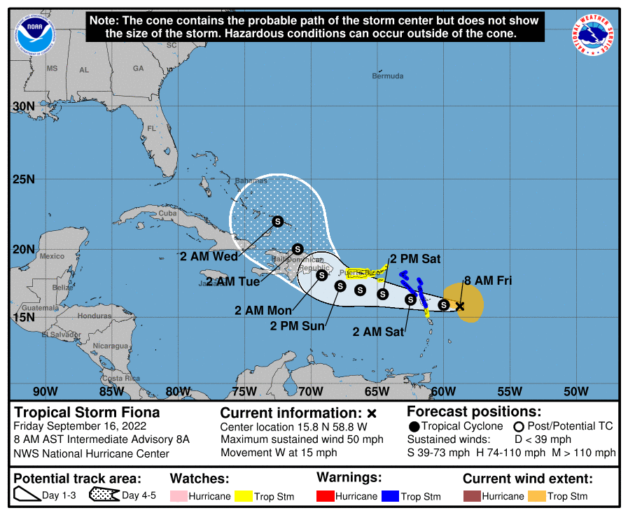
“On the forecast track, the center of Fiona is expected to move across the Leeward Islands [Friday] night, near or just south of the Virgin Islands and Puerto Rico Saturday into Sunday, and approach the southern coast of the Dominican Republic Sunday night and early Monday,” it added.
Data from Air Force Reserve and US Hurricane Hunter aircraft, it said, indicated that maximum sustained winds are near 50 mph (85 km/h) with higher gusts.
“Gradual strengthening is forecast during the next few days. Tropical-storm-force winds extend outward up to 140 miles (220 km) from the center,” it added.
Two systems form
Forecasters are also keeping watch over two weather systems slowly taking shape in the western and central Atlantic.
The first system, according to the NHC, is a frontal low area over the western Atlantic Ocean a few hundred miles west-northwest of Bermuda which is producing disorganised showers and thunderstorms.
“This low is expected to move eastward to east-southeastward at 10 to 15 mph, and development into a tropical cyclone is not anticipated due to strong upper-level winds,” it said Friday morning.
At this time the NHC gives the system a 10% chance of formation through the next five days.
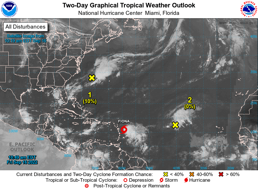
Meanwhile disorganised showers and thunderstorms over the central tropical Atlantic Ocean are being associated with the northern end of a tropical wave.
“Some slow development of this system is possible early next week while it moves northwestward to northward over the central subtropical Atlantic,” the NHC said.
The system has a low 20% chance of formation through the next five days.
For the latest information on storm activity in the Cayman Islands, as well as information on how to prepare for hurricane season, visit the ALT Storm Centre.
Related Videos


