
Along Seven Mile Beach, the line in the sand that determines property boundaries is so misleadingly measured that, in some cases, it is under several feet of water.
A government task force report, obtained by the Compass under the Freedom of Information Act, highlights concerns that coastal developers are exploiting a loophole in the system to encroach further and further on to the beach.
The result is a variety of pools, seawalls and, in some cases, condos that have been built closer to the water’s edge than intended, contributing to significant erosion issues.
The task force was set up in late 2021 at a time when government highlighted the disappearing beach front as a key national priority that was negatively impacting the crown jewel of Cayman’s tourism product.
The group, made up of senior civil servants in the lands, planning and environment ministries, as well as expert consultants, put forward a twin strategy.
A massive ‘beach renourishment project’ expected to cost around $22 million was proposed to replenish the worst-hit sections of the beach. And a new fixed reference line was recommended to ensure that any future construction is sited further inland and does not contribute to erosion issues.
Both proposals had the backing of Cabinet and appeared to be well advanced by the early part of last year, according to minutes of two government committees reviewed by the Compass.
However, both groups seem to have stopped meeting, without explanation, in March 2022, and the proposals have yet to be actioned. The ousting of Wayne Panton as premier and minister for sustainability and climate resiliency in the past week adds further doubt to the future of the proposals.
Government’s budget, expected to be brought to Parliament next month, will determine if the beach renourishment project proceeds at any point in the next two years.
Changes to the boundary line are potentially easier to implement and don’t rely on government funds. But conflict over potential impact on the rights of landowners and developers could complicate the issue.
The loophole
Current planning regulations require a single survey to establish the mean high water mark as the reference point for coastal building line “setbacks” for any given property. That survey has to be conducted within six months of an application to build. But the report highlights “the highly dynamic nature of coastline” along Seven Mile Beach, suggesting that it can fluctuate significantly in the course of a single day – even more so over six months.
Property owners take advantage of that flux by pressuring surveyors to conduct repeat surveys at optimal times in order “to maximise the extent of the Mean High Water Mark and thus allow development further seaward”, the report noted.
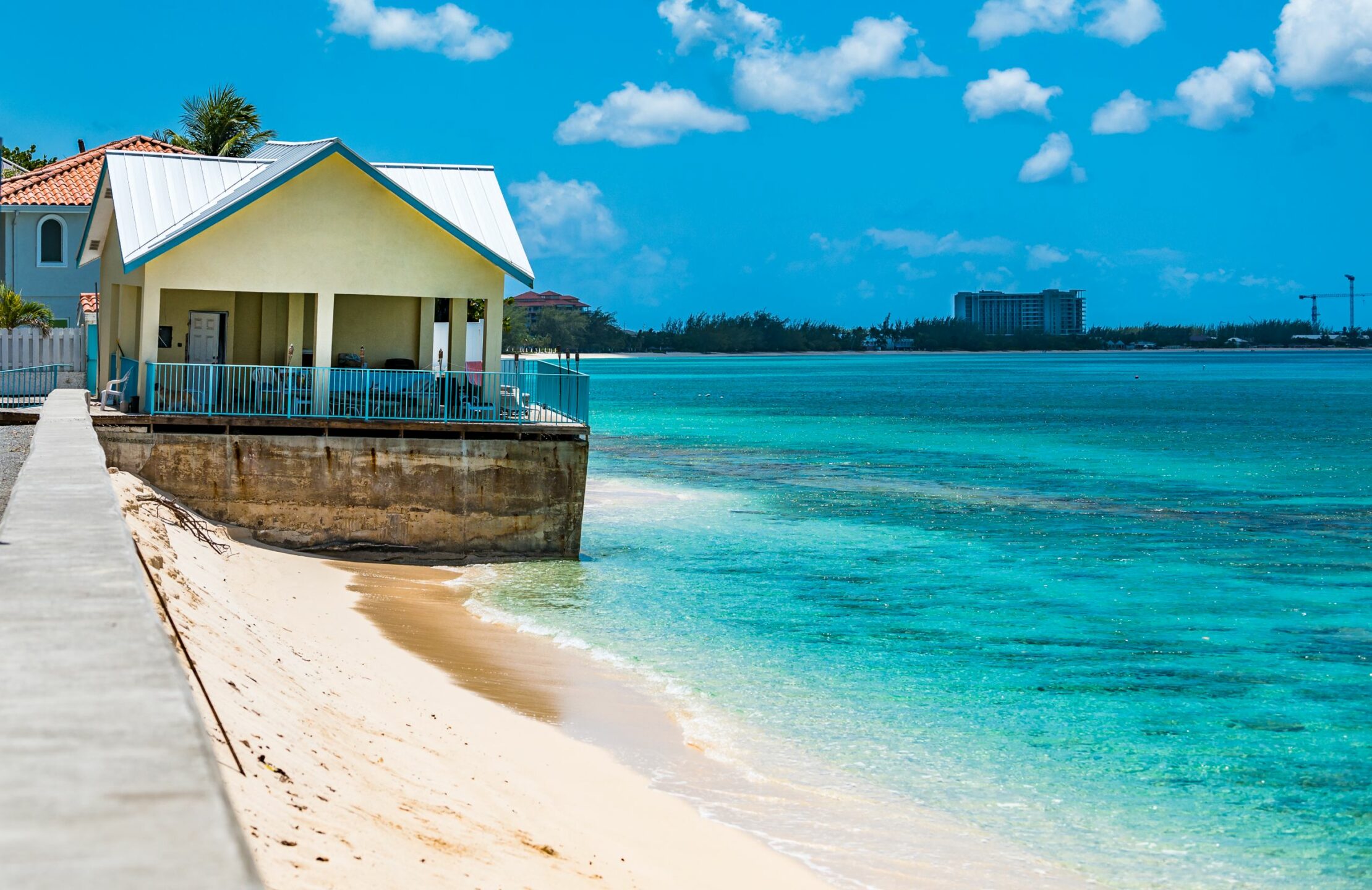
In one extreme case, a coastal property on Boggy Sand Road was cited as having registered a survey in the aftermath of a tropical storm – when its beach was plentiful. By the time a planning application was submitted, the beach had retreated by 31 feet, but the survey line – now under several feet of water – remained valid for the application.
“This situation is repeated numerous times, leading to considerable development encroachment on to the active beach and subsequently exacerbating erosion conditions when the seas interact with structures placed too far seaward,” the committee indicated.
The shifting line in the sand
The report highlights that the current issue – and many of the related erosion problems along Seven Mile Beach – stem from a policy change in the late 1980s. Up to that point, the ‘vegetation line’ had been the reference point for determining coastal setbacks.
But the shift to the current system meant that property could be built seaward of the beach ridge – cutting off the build-up of stores of sand that backed up in dunes during seasonal fluctuations of the coastline.
As the corridor of tourism properties developed in the following decades, that natural ability of the beach to flex with the conditions was diminished.
The committee considered reverting back to the vegetation line as the reference point, but concluded that the extent of construction along the beach made that impossible.
Instead it proposed a fixed ‘coastal setback reference line’ for the entire beach, based on 10 years of survey data of the mean high water mark.
“This provides an incredibly powerful and statistically robust data set with which to draw a meaningful and measurable understanding of the dynamics of the beach,” their report concluded.
Instead of a meandering line that often zig-zags into the water, this would give a smooth uniform boundary from which development setbacks could be determined.
Tim Austin, of the Department of Environment, which was part of the committee, said it was a subtle but important change that, if implemented, would help ensure consistency over how far property should be situated from the coastline. He said there were many areas along Seven Mile, and throughout the Cayman Islands, where the current reference line was under water.
“The beach changes radically from day to day, and you have people that do go out there and get the most favourable survey they can get and measure from there,” he said.
Currently, buildings along Seven Mile Beach must be set back 130 feet from the coast (based on the high water mark survey process described above). That would still likely be the case under the proposed new system, Austin said.
Though the committee disbanded in 2022 and the policy has yet to be actioned, Austin said the work has continued and a similar policy is in development for the entire island.
Property rights
The potential for property owners or developers to be adversely impacted by changes to the coastal reference line was flagged as a concern by a ‘steering group’ of government ministers, chaired by then Premier Wayne Panton.
Notes to an August 2021 meeting of that committee, provided to the Compass after an open records request indicate, “Compensation discussed for landowners if development capacity is impacted by changing reference line. Right thing to do for property owners affected by any change – legal advice needed.”
Minutes to a subsequent meeting indicate the possibility of “compensating” landowners by allowing them to build higher “to compensate for the loss of footprint”.
Samuel Jackson, a lawyer who specialises in development and planning matters, told the Compass that he has always supported the concept of a fixed reference line for coastal development, making a similar proposal to government himself in 2016.
With the benefit of hindsight, he said the “beach ridge”, which he believes would have coincided with the original vegetation line, should have been used as the reference point for coastal setbacks.
“If we had set the building line to coincide with that static line, then there wouldn’t have been any issue with erosion being caused by the buildings,” he added.
He believes a fixed line would remove a degree of uncertainty for property owners and could also help clear up any confusion around public and private property rights on coastal land.
Jackson also said he does not believe that coastal property owners along Seven Mile Beach would necessarily have needed to be compensated, because the Prescription Act – if properly interpreted and enforced – already preserves the active area of the beach for the use of the public.
“To some extent, it doesn’t matter who owns it,” he said, “no one can stop the public from using that part of the existing beach area, which they have a long-established prescriptive right to use.”
The tricky part has always been figuring out exactly where the ‘public prescribed area’ is,” he said.
“My own view is that we simply need to look at historical aerial photography to establish where the original vegetation line was, which most likely coincides with the ‘beach ridge’, and everything seaward of that should be considered as the beach,” he said, adding that public right of access and use of that area was protected and ‘indefeasible’ under the Prescriptions Act.
Managed Retreat
The lawyer warned that changing the reference line could only apply to new development, however.
Given the development that has historically been allowed, he said it would be unfair to prevent property owners from repairing or redeveloping structures already in place.
This has been a recent source of conflict between coastal property owners on Seven Mile Beach who have sought to rebuild damaged seawalls and the National Conservation Council, which would like to see a national policy on seawalls and for all structures moved back from the water’s edge as they are rebuilt or repaired.

“Given that we have had many older development sites that are now exposed to serious risk of damage or even destruction by the storm surge,” he said, “it would be an ill-fated exercise for government to try to impose any sort of ‘managed retreat’ process on such existing buildings or the renovation or refurbishment of protective walls for such buildings that are in situ, since the owners of those usually very valuable properties have constitutionally protected legal rights which they would, no doubt, enforce against the government.
“The focus would have to be on new development sites or redevelopment sites which involve the construction of entirely new buildings.”
Austin said the line was intended as a reference point to help determine where building should be allowed. It is not a boundary that aims to determine where private property ends and public land begins, which, he said, is a different, though equally important debate, governed by a number of different laws.
He said technical work was continuing by the Department of Environment as they await a government decision on how to proceed.
A spokesperson for the Ministry of Sustainability and Climate Resiliency did not answer questions on what had delayed the process since last spring, but indicated support for the policy proposal.
The spokesperson said, “Developing a new regime for coastal construction setbacks requires a holistic, coordinated approach across relevant ministries, and strategic actions for revising coastal setbacks are included in both the draft Cayman Islands Climate Change Policy 2023-2050 and the PlanCayman National Planning Framework, which is being used to inform an updated Planning Statement.
“With both of these important projects moving forward – and given the increasing urgency to ensure the Cayman Islands’ climate resiliency – the Ministry of Sustainability & Climate Resiliency looks forward to working with the relevant stakeholders to develop a recommendation for an updated coastal setback reference line for Seven Mile Beach based on decades of coastal data.”
Related Videos


Regarding Beach Erosion: Just a thought – but has anyone thought that the last earthquake a few years back with a magnitude of 7 plus caused a fissure on the ocean floor, thus the loss of sand? Something to think about.