
A system currently located near the Yucatan Peninsula and the Southeastern Gulf of Mexico is set to become a tropical storm later Friday, forecasters have said.
In an advisory Thursday night, the Cayman Islands National weather Service said it does not foresee any change in local weather conditions due to the system.
“We will continue to experience cloudy, rainy conditions through Saturday night as Potential Tropical Cyclone One moves across South Florida by Saturday afternoon,” it said.
However, a small craft warning is in effect and thundershowers are expected Friday afternoon.
Rough seas, with wave heights of six to eight feet, have been forecast with winds blowing southeast at 20 to 25 knots.
On Friday, the US National Hurricane Center issued advisories on the system, currently located near the northeastern portion of the Yucatan Peninsula.
“The system is expected to develop a well-defined center and become a tropical storm later [Friday], and some slight strengthening is possible while it approaches Florida [Friday] and
[Friday] night. Additional strengthening is possible after the system moves east of Florida over the western Atlantic late Saturday and Sunday,” the NHC said.
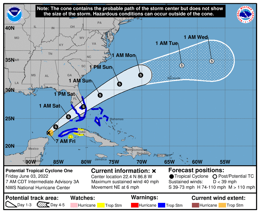
The system is moving toward the northeast near 6 miles per hour, the NHC said, adding that this general motion with an increase in forward speed is expected to begin later Friday and continue through Sunday.
“On the forecast track, the system is forecast to move across the southeastern Gulf of Mexico through tonight, across the southern and central portions of the Florida Peninsula on Saturday, and then over the southwestern Atlantic north of the northwestern Bahamas Saturday afternoon through Sunday,” it said in the advisory.
Data from an Air Force Reserve Hurricane Hunter aircraft indicate that maximum sustained winds remain near 40 mph (65 km/h) with higher gusts. Tropical-storm-force winds extend outward up to 60 miles to the east of the center.
The system has a 90% chance of formation over the next 48 hours.
Meanwhile forecasters are monitoring a small area of low pressure located more than 200 miles west-southwest of Bermuda which is producing a small area of showers and
thunderstorms.
“This system only has a brief window for further development [Friday] before environmental conditions become increasingly unfavorable by this weekend. This system is expected to move generally eastward to the south of Bermuda,” the NHC said.
For the latest information on storm activity in the Cayman Islands, as well as information on how to prepare for hurricane season, visit the ALT Storm Centre.
Related Videos


