
The debate over plans for a 10-mile extension to the East-West Arterial has kicked into high gear over the past few weeks as preliminary work to begin the controversial project got under way.
The road project, first gazetted in 2005, has been on the horizon for some time and the Compass has already done considerable reporting on its likely impact on traffic, the environment and development in the eastern districts.
Here, journalists James Whittaker and Norma Connolly seek to answer some of the central questions around the road and what it means for Cayman.
Will the road improve journey times from the eastern districts?
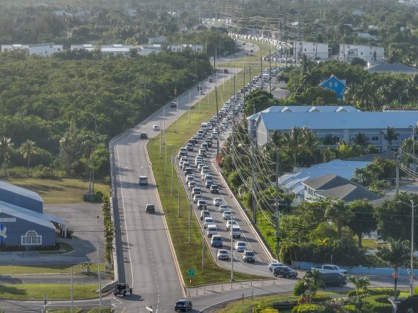
Much of the debate around the plan to extend the East-West Arterial highway has focused on its capacity to reduce journey times for commuters in the eastern districts. Frustrated residents told stories of feeding their children breakfast in slow-moving vehicles on a pre-dawn trek to school (presumably to private schools in George Town rather than district primary schools or to Clifton Hunter High School in North Side).
The case for doing something about traffic is inarguable. But whether the highway will make a huge difference is a much more debatable point.
According to data from the National Roads Authority, any gains will be temporary. In fact, the NRA anticipates journey times will increase with the new road – and a suite of other highway modifications closer to George Town. That’s because the population is expected to continue to grow, bringing more commuters and more cars to the more affordable eastern districts.
However, the NRA forecasts that, without the roadworks, journey times will increase even further.
Dwayne Seymour, the MP for Bodden Town East, spoke for many when he said at a public meeting last week, “we just want one more hour’s sleep”. The reality is he is unlikely to get it. By the time the road is built, the population will have increased to such a degree that the journey times will actually be a little longer than they are now.
Seymour may even have to get up 15 minutes earlier. However, the population is likely to increase – and is already increasing – regardless of whether the road is built. And the NRA’s data shows that if it doesn’t act, then the commutes will be significantly longer. Eastern district residents could be looking at a 5am start and even less time in bed.
What about the bottlenecks at Grand Harbour and closer to George Town?
It’s been argued, with some justification, that no amount of road development east of the capital will have a significant impact because all traffic must still pass through the bottlenecks at Grand Harbour.
The NRA has confirmed that the impact of the new road on traffic congestion at the Grand Harbour roundabout area is not part of the scope of the current environmental impact assessment for the East-West Arterial extension.
However, managing director of the NRA, Edward Howard, stated that, even before preparations for the East-West Arterial Extension EIA had started, a separate ‘corridor study’ involving the Grand Harbour roundabout had begun, which would include the effects of the expanded highway on traffic in that area.
The results of that study are expected to be released this month.
The NRA is also working on a number of road-widening projects in and around George Town which it believes will make the final part of the journey into the capital smoother.
Is it possible that the road could increase traffic issues?
It’s logical that the road will, at least temporarily, ease traffic, compared to a scenario where no road is built. But over a longer term, there is a possibility that the highway corridor will inspire new development.
There’s no development plan in place and no specific zoning plan for the highway corridor to control how that development takes place. It’s therefore feasible that significant new sub-divisions, condos and housing developments spring up along the route – which will open up previously landlocked parcels for development.
That will mean an increase in people and an increase in cars, potentially wiping out any traffic gains because of the road.
“Once the road comes in, the land will likely be sub-divided and there will be building that takes place,” Uche Obi, director of the Department of Lands and Survey, told the Compass last year. “The road is definitely going to have an impact on adjacent parcels.”
Is that a bad thing? Don’t people need somewhere to live?
The reality is that Cayman’s population is growing faster than anyone predicted and is outpacing its roads and housing infrastructure. The NRA used 80,000 people as a population estimate to feed data into its projections for how our traffic may look in 2026.
Recent estimates suggest we are already past that figure and heading inexorably towards the NRA’s 2036 projection of 100,000.
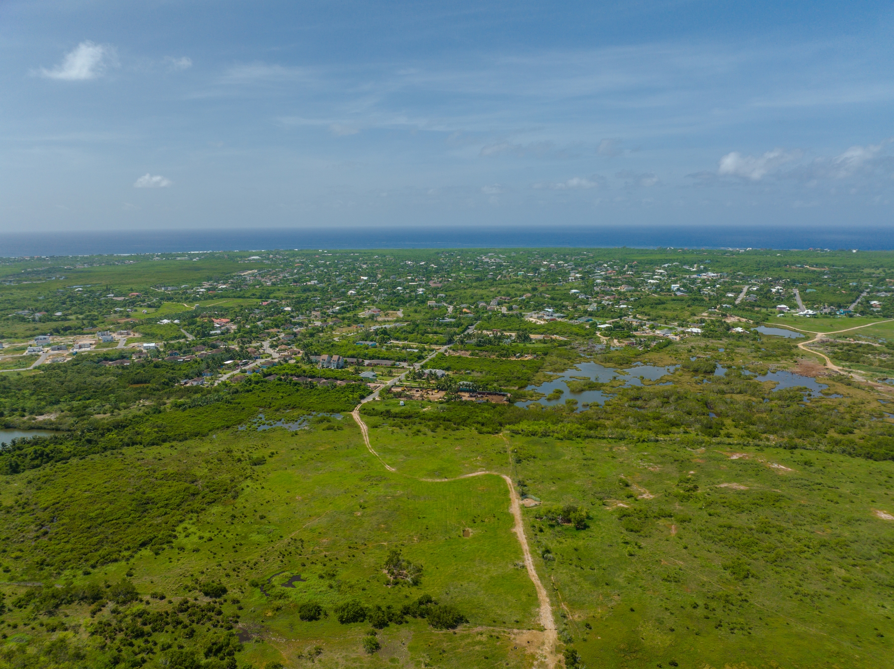
The road extension – particularly the phase from Savannah to Bodden Town – will open up developable land that could be used for more affordable housing.
Those who oppose this development, including sustainability groups, argue that controlling population growth would be a better approach.
Who owns the land in the road corridor?
Landowners along the route, according to Compass research using the Lands and Survey database, include the Dart group, Frank Schilling and Jay’s Heritage Holdings.
The National Trust also owns some of the most environmentally sensitive land within the road corridor.
Schilling, who owns a 613-acre parcel close to Northward, recently told the Compass it would be a good plot for a sub-division.
He has no current plans to develop the land himself, however, and is looking to sell his holdings in the area.
He said there are significant portions of land, particularly on the section of the road corridor between Hirst Road and Bodden Town, that would be suitable for development and could provide answers to Cayman’s affordable housing issues.
He believes the wetlands should be protected in perpetuity, however.
Is there compensation for property owners who give up land for the road?
The Roads Law empowers government to take land once a ‘section 3’ notice declaring the intention to build a road over that land has been issued. Compensation is through negotiation.
Where a fair price can’t be agreed, a tribunal and, ultimately, the courts can settle the matter. In some cases, the road actually adds value to the property because it opens up land-locked parcels, making them commercially more viable for development.
Where that is determined to be the case, no compensation is paid.
Why not prioritise public transport instead?
The NRA says the road includes capacity for bus and bike lanes, but they are not factored into the current planning.
A public transport policy is outside of the roads authority’s remit, but it insists the infrastructure will make that more feasible. The NRA also adds that the creation of arterial highways could free up the coastal roads – currently congested with traffic – for cycles and other forms of transport.
However, there is no current plan in place to make this happen. Premier Wayne Panton, speaking at the Chamber of Commerce annual general meeting last week, indicated that government will develop a comprehensive transport plan.
He said this would involve “continued progress on critical road infrastructure, but also provides incentives for car sharing, biking and a new clean, reliable public transport system”.
How will the road impact the Central Mangrove Wetland?
The road, if it goes ahead as proposed, will cross through 174 acres of the wetlands, affecting them directly, through there are numerous other “indirect” impacts that the EIA will explore. As well as potential impacts the road will have on the flora and fauna of the wetlands, one of the major concerns is the possibility of increased flooding as the road could effectively ‘dam’ the wetlands.
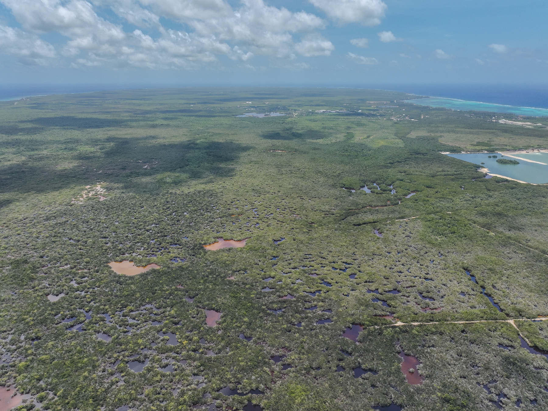
During storms and hurricanes, flood waters drain from the south to the north through the Central Mangrove Wetland, so the road, which is proposed to be built along its southern boundary, is likely to have an impact on the natural drainage processes.
The wetlands are part of a large-scale water flow system that filters and conditions the surface water and shallow ground that flows into the North Sound, and provides a constant source of nutrients that are the base of a complex food chain for both terrestrial and marine wildlife.
This means that adverse effects on the mangrove wetlands will have a knock-on effect on the North Sound, as well as the Lower Valley and North Side freshwater lenses.
There are also concerns that removing mangroves and interfering with the water flow in the wetlands will affect weather patterns on island.
The wetlands create an estimated 40% of the rainfall in the central and western districts, due to a natural process known as ‘evapotranspiration’, in which saturated air rising from the wetland forms rapidly developing clouds that are carried west by prevailing winds and dump rain over the land. The removal of mangroves could also reduce protection from tropical storms and hurricanes.
The draft terms of reference for the EIA also notes that the proposed roadway has the potential to release contaminants that may pollute sensitive habitats and the underlying water-bearing permeable rock.
What will the Environmental Impact Assessment look at?
The EIA has a broad scope and will look not just at the direct and indirect environmental impacts from the road.
Among other elements, it will also explore socio-economic effects, such as the impact that not building the road would have on people’s travel time and the loss of manhours due to traffic congestion, as well as the potential for job creation during construction of the road, business and employment opportunities that result from implementation of the road, and the potential for new development in the area.

Additionally, it will consider the route alignment and assess alternatives, and will explore issues of hydrology and drainage, including climate resiliency.
The EIA will look at the impact on freshwater lenses, loss of habitat, potential loss of species through disturbance or cars colliding with wildlife, runoff from construction work and the roadway, the impact of artificial lights on the surrounding natural area, and reduced waterflow.
The study will also look at potential impacts on ‘cultural and natural heritage sites’, including the Central Mangrove Wetland, the Mastic Reserve and the Mastic Trail.
Greenhouse gas emissions during the construction of the road is another element of the EIA, as well as the impact of noise and vibration during construction and once the road is operational.
Apart from highlighting the possible impacts, the EIA will also explore mitigations for those impacts.
Is there an alternate route?
While the EIA does not explore a specific alternate route, it will consider three possible options for the proposed extension of the East-West Arterial.
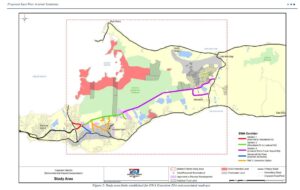
These include: 1) not building the road at all; 2) a ‘build in gazetted corridor’ option, which would involve changing existing roadway locations and layouts, such as using bridges to elevate roadways, and; 3) changes to Bodden Town Road to include limited rights of way, dedicated lane for public transport and pedestrian/bicycle use, and adding or widening lanes on existing roads.
How long will it take to build?
The exact timeline for the construction of the road is not yet known, though it certainly won’t be completed before the next election, expected in mid-2025.
The environmental impact assessment, which is expected to take a year to complete, has not yet begun, as the process for drawing up the scope of the assessment is still under way. The public consultation on the terms of reference of the EIA ends on 20 Feb. Once that is complete and the terms of reference have been finalised, the EIA can begin.
After that’s been completed, a draft environmental statement will be drawn up, and will also be subject to public consultation before Cabinet can approve it. Once that’s done, the work on the 10-mile expansion road can begin.
The lifespan of the road is expected to be 40 years, according to the EIA draft terms of reference.
Related Videos


We should look at an alternative, it maybe feasible to put some tunnel segments in the North Sound at the end or under the planned runway extension.
Linking Hurleys roundabout / Periwinkle /Careenage with the new bypass rd from Camana Bay/ international school to Hurleys and bypassing Georgetown and giving an alternative access rd to industrial park and airport. Another option is spreading traffic by for example start work at construction sites at 6:30 AM
Roundabouts can only handle a certain traffic flow no matter how many lanes due to people crossing over the lanes to reach their exit.
The obvious answer is an overpass (flyover). But installing traffic lights on the roundabouts for rush hour use would help greatly. This is often done in the UK.
Take the ALT roundabout. Traffic from the Esterly Tibbetts to the North Sound Road is stuck solid due to cars entering the roundabout from the Godfrey Nixon entrance. Imagine if there were traffic lights stopping those cars at intervals.
To permit the Godfrey Nixon vehicles to enter freely have lights stopping the east west traffic. This will be faster for everyone.
“no amount of road development east of the capital will have a significant impact because all traffic must still pass through the bottlenecks at Grand Harbour”
That is the bottom line