
West Bay residents have voiced their reservations over plans for 34 new townhouses which they say will create an unmanageable amount of traffic in the area.
One described the $7 million project on Lindy’s Walk as “absolutely appalling”, while another said the likely increase in vehicles on the nearby roads “makes it very dangerous”.
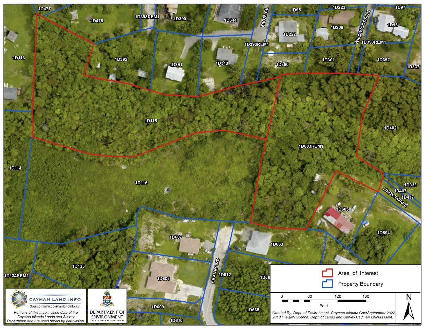
COE Group presented its plans for the 2.6-acre townhouse community, two pools, a fence, gate and cabanas to the Central Planning Authority on Wednesday, 12 April.
The complex will include 57 bedrooms and 71 parking spaces, the developer’s plans said, and will be accessed by a series of roads that link to Watercourse Road.
Access roads
The Planning Department, in its analysis of the plans detailed in the meeting agenda, discussed the suitability of the access roads.
The first access road off Watercourse is Ebanks Road, the department said, which at its narrowest is 14-foot wide and contains several twists and turns.
“It is questionable whether a 14-foot wide access road is enough to support 34 apartments and the associated traffic,” it wrote.
The next access road is Florrie Dell, which is 30-foot wide and also contains a number of twists and turns, then Lindy’s Walk, a 30-foot wide road with a sharp corner, it said.
“It would appear that the road network will be problematic during construction and also once the proposed project is complete,” the Planning Department wrote in the agenda.
The National Roads Authority, in its analysis, said the proposed access is on an unbuilt portion of road so the applicant will need to upgrade both Florrie Dell and Lindy’s Walk.
It cautioned the planning authority on approving a multi-family development where it said a portion of Florrie Dell is less than 15 feet wide.
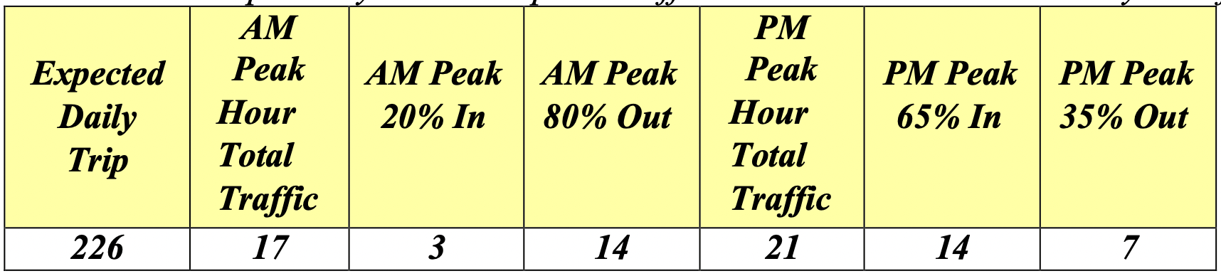
According to its estimates of anticipated traffic at peak times, the NRA said it considers the impact of the proposed development as “moderate”.
Three representatives for the applicant attended the planning meeting, during which they questioned the accuracy of the NRA’s measurements.
They said they had commissioned their own survey which stated the road widths were slightly wider than what the NRA had calculated.
The representatives added that it is the NRA’s responsibility, not theirs, to make the roads meet standards and allow appropriate access to the community.
An ‘atrocity’
The planning authority notified adjacent landowners of the planned project prior to the meeting, and three objections were raised in writing and included in the agenda.
The first objector said they were concerned about “potentially hundreds of persons” needing to use the access from Watercourse Road.
They said the build will negatively impact the community because there is not a proper road to facilitate the number of cars and service vehicles.
Some areas of the access roads are narrow and have tight corners, which often lead to bottlenecks and traffic coming to a complete stop at points, they added.
The objector said more traffic would make it very dangerous.
The second objector called the proposed project “absolutely appalling” and said the little community is not the appropriate place for such a development.
“We have children playing, riding bikes, skateboards, playing ball and all of the other things that children do. There is even a little park in our community,” they wrote.
“I would hate to see anything happen to anyone’s child including my very ow grandchildren. It is that small a community.”
The nearby resident said the little roads are suitable only for one car and an increase in the flow “is just a horrific accident waiting to happen”.
“This can’t be approved. I find it absurd that anyone could find this a good idea,” they said, adding that they object deeply to the project that they called an “atrocity”.
A third objector echoed the sentiments of the first two, adding that they submitted plans for six apartments in 2006 and were refused because of the width of the access road.
Valuable habitat
The Department of Environment, in the agenda, said the site consists of primary dry shrubland and forest along with some previously modified land with additional growth.
It said these habitats offer “valuable ecological services and benefits” such as privacy screening, low-cost landscaping, shade, stormwater management and drainage.
They also provide a habitat for endemic wildlife, help to cut back on carbon emissions and create wildlife corridors.
“Primary habitat is in severe decline and becoming a scarce and highly threatened resource as a result of land conversion for human uses,” the department wrote.
It questioned the need to convert more areas of valuable habitat for apartments “at this time for this use”.
The Planning Department also mentioned the requirement for an additional accessible parking space; however, this was rectified after the agenda was published.
It added that the proposed fence is two feet higher than guidelines and the gate is set back six feet closer to the road than advised.
The decision will be published in the Central Planning Authority’s minutes in the coming weeks.
Related Videos


Waky Waky What about the hundreds of new properties around Grand Harbour . The traffic island there must already be the biggest bottle neck on the island.