
For the latest information on storm activity in the Cayman Islands, as well as information on how to prepare for hurricane season, visit Storm Centre.
Updated 1 June 2023 at 6:30pm: Tropical Depression Two has formed in the northeastern Gulf of Mexico, the US National Hurricane Center advised Thursday afternoon, and is on track to become the second storm of the 2023 Atlantic hurricane season.
The first storm system came by way of a rogue storm in January.
National Weather Service meteorologist Shamal Clarke, in his afternoon forecast Thursday, said the depression, which poses no threat to the Cayman Islands, is located about 305 miles west-northwest of Ft. Myers, Florida.
Tropical Depression Two is moving west-northwest at 2 miles per hour with maximum sustained winds of 35 mph, he said.
The NHC said the motion to the south is expected to begin by Friday, with gradually increasing forward speed.
“Maximum sustained winds are near 35 mph (55 km/h) with higher gusts. Some modest intensification is forecast, and the depression could become a tropical storm [Thursday night] or [Friday]. However, the system should begin to weaken by Friday night and degenerate into a remnant low by Saturday,” the NHC said in its later advisory Thursday evening.
It said a National Oceanic and Atmospheric Administration buoy recently reported sustained winds of 36 mph with a gust of 40 mph.
Original story: The Atlantic Hurricane Season has officially commenced and already there is a system churning in the Gulf of Mexico which may develop into a short-lived tropical depression or storm as early as Thursday afternoon.
The system, according to the US National Hurricane Center in Miami, has a 70% chance of cyclone formation in the next 48 hours and is located in the northeastern Gulf of Mexico.
Based on its location the storm is not set to impact the Cayman Islands, according to National Weather Service Chief Meteorologist Kerry Powery Linwood.
“There is no steering pattern in that area so it will sit around there or drift in the northeastern Gulf of Mexico,” Powery Linwood said.
He said the NHC was expected to conduct reconnaissance Thursday to investigate the system.
However, he said, the system “should not be of concern” for the Cayman Islands as the overall pattern does not bring into the Cayman area.
An Air Force Reserve Hurricane Hunter aircraft is scheduled to investigate the system, an NHC advisory Thursday said.
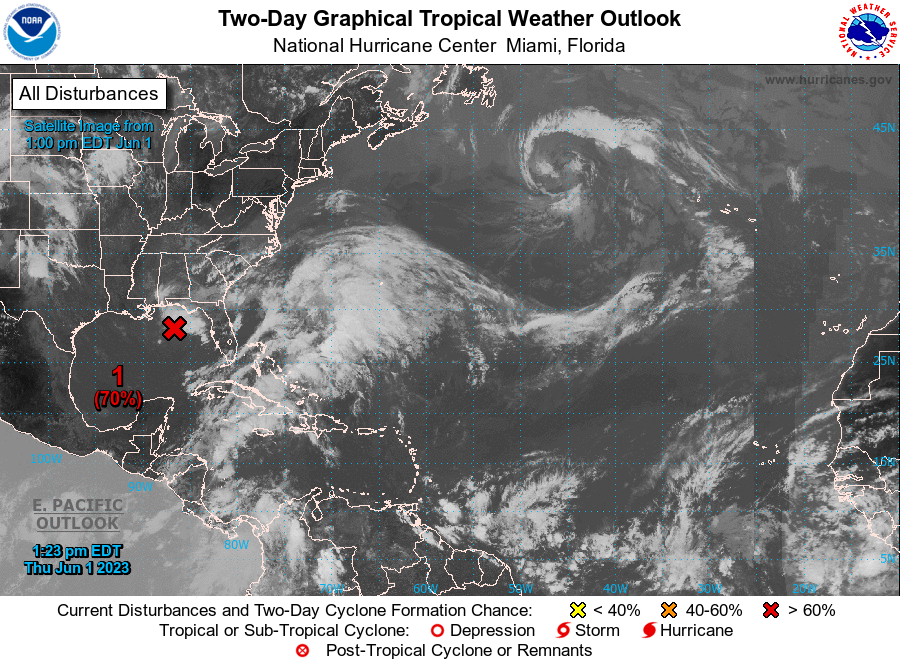
This is the second weather system to appear on the NHC’s radar system since it began publishing daily updates on 15 May. However, it is not the first storm system of the 2023 Atlantic hurricane season, which came by way of a rogue storm in January.
US weather forecasters have predicted near-normal hurricane activity in the Atlantic this year, with up to nine hurricanes and four major hurricanes.
The National Oceanic and Atmospheric Administration on 25 May published its outlook for the 2023 Atlantic hurricane season, which runs from 1 June to 30 Nov., saying, with 70% confidence, that there will be between 12 and 17 named storms with winds of 39 miles per hour or higher.
Of those, five to nine could become hurricanes with winds of at least 74mph, and one to four of those may be Category 3 to 5 major hurricanes with winds of at least 111mph.
System showing defined organisation
It pointed out that recent satellite wind data, along with buoy and ship observations, indicate the area of low pressure “has a broad but well-defined circulation’ with maximum sustained winds of about 35 miles per hour”.
It noted, “Shower and thunderstorm activity associated with the low is also showing signs of organization. Environmental conditions remain marginally favorable for additional
development, and if these trends continue, a short-lived tropical depression or storm is likely to form as soon as [Thursday] afternoon.”
The NHC said the system is likely to meander over the northeastern Gulf of Mexico
through Thursday night but begin a slow southward motion on Friday.
“By this weekend, environmental conditions are forecast to become unfavorable for additional development as the system continues moving southward, likely remaining offshore over the Gulf of Mexico,” it said, adding that regardless of development, locally heavy rainfall could occur over portions of the Florida Peninsula through this weekend.
Powery Linwood said Cayman will expect rainy weather over the next day as the system and a trough in the area produce showery activity.
However, he said, that trough is already drifting away from Cayman and the overcast conditions should clear for the weekend.
The Thursday afternoon forecast stated that cloudiness and scattered showers are expected to continue for the next 24 to 36 hours due to an interaction between the weak pressure gradient at the surface and a broad upper level trough across Guatemala.
Related Videos


