
Three alternative routes for the long-anticipated East-West Arterial are now before Cabinet for consideration, who must make a decision on the matter before it can move forward to the next stage of its environmental impact assessment.
Environmental Advisory Board Chair and Department of Environment Director Gina Ebanks-Petrie, speaking at Wednesday’s National Conservation Council meeting, said the project is now at the selection stage for a preferred alternative route.
“That decision has been put to Cabinet by the [transport] ministry, which has responsibility for the National Roads Authority,” she said.
The Environmental Advisory Board, she said, provided input to the selection process based on the current results from the EIA some time ago.
However, she said the board was not yet aware of where the Cabinet’s deliberations were for selection of a preferred alternative.
Ebanks-Petrie said only three alternative route proposals had been submitted.
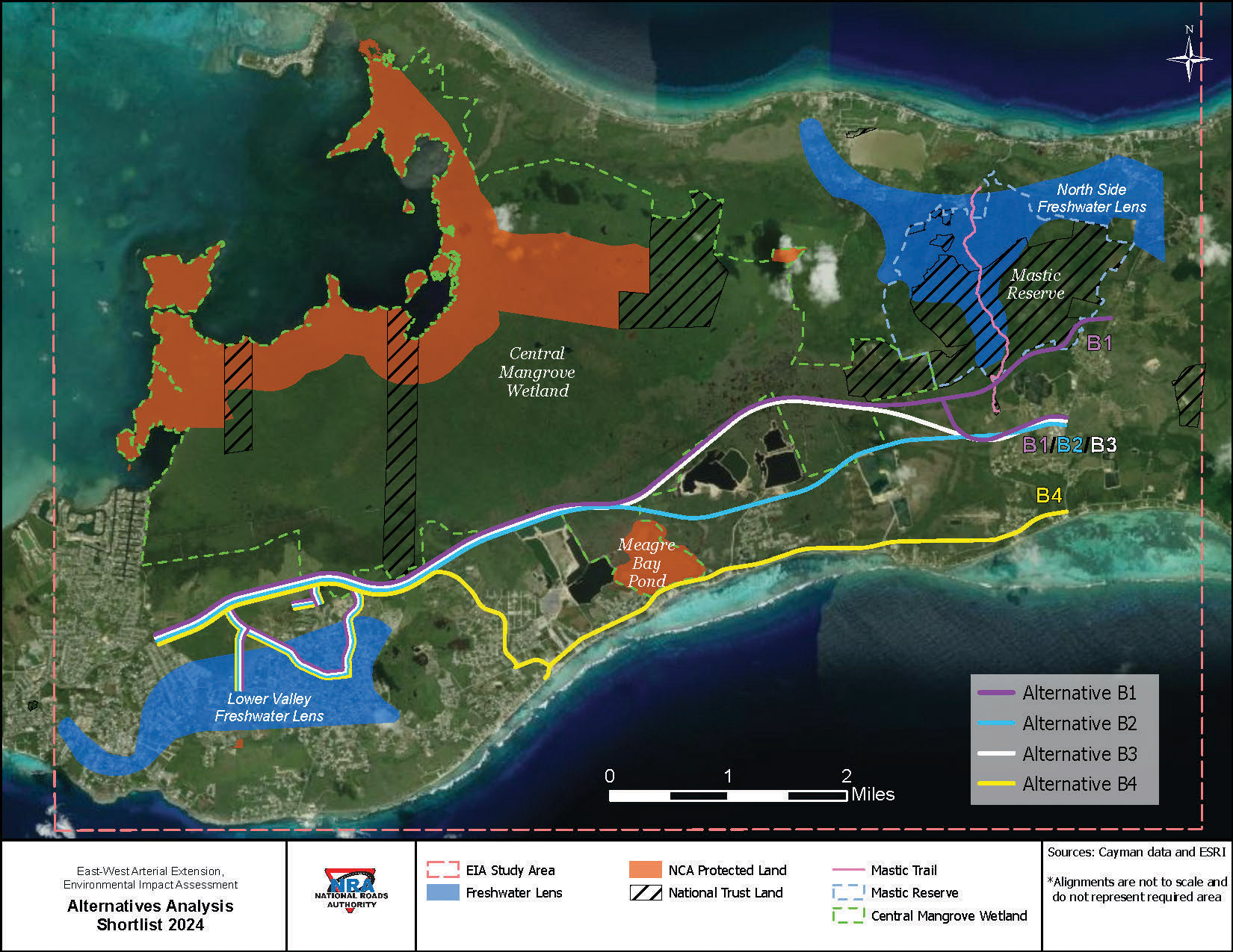
This week, the NRA published a map of four shortlisted alternative routes for the project on its EIA site for the arterial. It is unclear which of the routes on the NRA map is not being pursued as an alternative option.
There has been no official announcement on the progress of the project from NRA nor the transport ministry.
The Cayman Compass has reached out to the NRA for an update and is awaiting a response.
Next steps
Ebanks-Petrie, in her update, said once a preferred alternative has been selected, the roads authority’s EIA consultants, Whitman, Requardt and Associates, known as WRA, will then continue with a more detailed environmental assessment on the exact route of the preferred alternative.
“Following that, we will then be in a position to assemble the technical chapters of the environmental impact assessment, which have already been reviewed by the [Environmental Advisory Board] in relation to the three alternatives that have been assessed to determine the preferred alternative,” she said.
Those chapters, she said, will then be assembled into a concise document outlining the likely effects of the preferred alternative route on the environment and vice versa.
“We’re waiting for decision-makers in relation to the East-West Arterial,” Ebanks-Petrie said.
It will fall on Cabinet to decide which route to approve for the project. The possible options include the contentious, originally proposed route.
The East-West Arterial is a 10-mile long “multi-modal and multi-tiered corridor,” according to the NRA.
The extended route is divided into sections – Hirst Road to Woodland Drive (section 1), which is under construction, Woodland Drive to Lookout Road (section 2) and Lookout Road to Frank Sound Road (section 3).
There is also the Will T Connector, which the NRA said will bring improvements to the local road network, providing access to section 2.
The current EIA study applies to sections 2 and 3.
Sustainable Cayman pushes Alternative Route B2
Meanwhile, Sustainable Cayman, which has been closely following the developments on the project, said Alternative Route B2 should be the preferred choice for the road extension.
This route, it said in an emailed comment to the Compass, minimises the impact on sensitive habitats, reduces the potential for sprawling development, and meets community needs by connecting social resources.
The consulting “optioneering report” Alternative Route B2, it said, stretches approximately nine miles and was deemed the best option due to its strategic connectivity to key community facilities such as schools, residential areas and emergency services.
“This route not only facilitates daily commutes and access to vital services but also ensures residents’ safety and well-being by providing efficient emergency response access. Designed to integrate seamlessly into the existing infrastructure, it enhances the overall functionality of the transportation network,” the conservation group said in an emailed comment.
It said it would not be inclined to support Alternatives B1 and B3 due to their northern positioning in the Central Mangrove Wetlands.
These locations, it said, would likely increase development pressures, increase stormwater flood risks to the existing population, and limit accessibility while incurring higher predicted foreign engineering and costs.
The local environmental group, which has launched its ‘Wetlands Thrive, Life Survives’ campaign, said its advocacy for Alternative Route B2 “has been pivotal in ensuring the chosen route supports environmental sustainability while addressing human needs”.
It cited the route’s minimal impact on the stormwater management systems as an advantage, which it said is thanks to its southern location compared to Alternatives B1 and B3.
“By reducing strain on these systems, the route helps mitigate flooding risks, a critical concern for areas prone to seasonal and tidal flooding. The lack of a comprehensive hydrology report, however, raises concerns about potential stormwater flooding near Woodland Drive,” it said.
It added that the report is crucial to fully assess the impact and implement necessary measures to prevent flooding in built-up areas.
“The benefits of Route B2 in terms of connectivity, reduced environmental impact, and social advantages make it the most viable option. Its thoughtful planning and community-focused design promise the greatest potential for positive outcomes in the region, so long as the road is built with flood mitigation in mind,” it added.
Related Videos


