
For the latest information on storm activity in the Cayman Islands, as well as information on how to prepare for hurricane season, visit Storm Centre.
The Cayman Islands could feel the impacts of Hurricane Beryl starting as early as 7pm Wednesday, forecasters warn.
The Cayman Islands remains under a hurricane warning and residents should make preparations now for potentially devastating storm impacts, including hurricane-force winds and life-threatening storm surge.
Based on the latest predictions, the National Weather Service said the projected onset of tropical-storm-force winds on Wednesday should begin by 7pm on Cayman Brac, 8pm on Little Cayman, and 11:30pm on Grand Cayman.
“The center is expected to pass near or over the Cayman Islands Wednesday night or early Thursday and approach the Yucatan Peninsula of Mexico Thursday night,” the US-based National Hurricane Center said Wednesday evening.
“Hurricane conditions are expected to reach the Cayman Islands Wednesday night or early Thursday. Winds are expected to first reach tropical storm strength on Wednesday, making outside preparations difficult or dangerous.”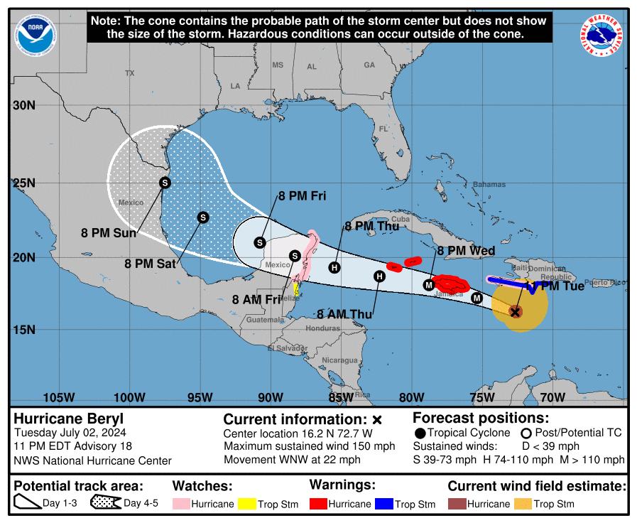
A flood warning has also been issued, as Cayman anticipates 4-10 inches of rainfall from the hurricane, the Cayman Islands Government said. Officials urged residents to be prepared to evacuate to higher ground if instructed to do so or if water levels begin to rise.
“Take essentials like medications, important documents, and a flashlight,” officials advised.
Residents should avoid flood waters, as they can be contaminated, dangerous and life-threatening. Six inches of moving water can knock a person down, government advised.
Storm surge could raise water levels 2 to 4 feet above normal tide levels along coasts in the Cayman Islands, the NHC said.
Wave heights will reach 6-9 feet Wednesday evening and 10-15 feet on Thursday, according to the Cayman Islands Government.
“Safety should always come first. Do not enter buildings surrounded by floodwaters until they’ve been deemed safe by professionals,” a government press release said.
“Keep in touch with family and friends to let them know your whereabouts and safety status. Stay calm and follow instructions from emergency services.”
The Cayman Islands Regiment will be assembled as of 10am Wednesday and deployed at noon following official orders, the Cayman Islands Government said. The National Emergency Operations Centre will also meet at 10am in preparation for Hurricane Beryl’s passage.
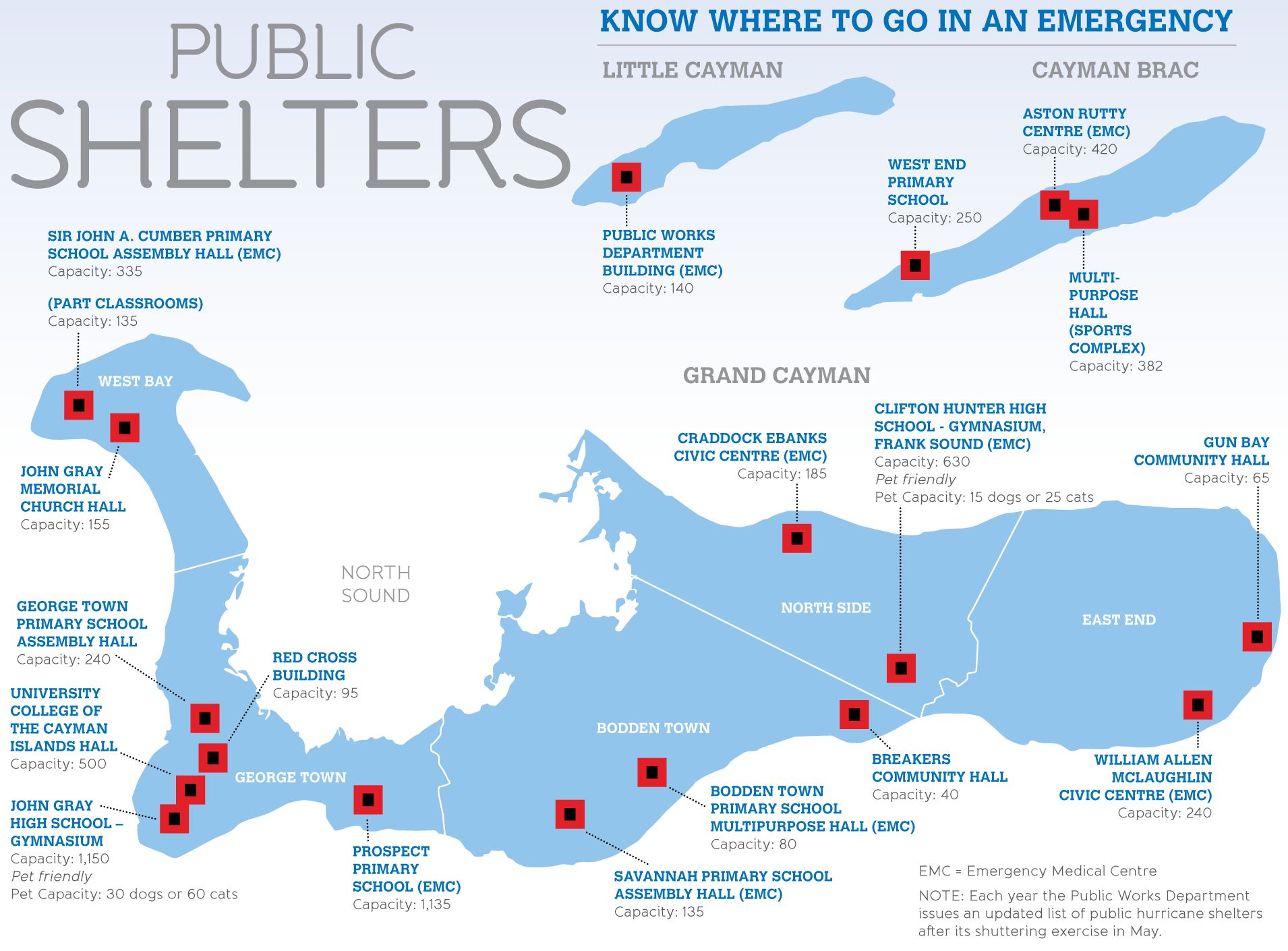
The Cayman Islands Red Cross gathered 74 volunteers and distributed kits to 32 shelter managers on Tuesday evening in preparation for the storm. The Red Cross shelter on Huldah Avenue will open at 9am on Wednesday.
As of 7pm Tuesday, Hurricane Beryl was located approximately 663 miles east-southeast of Grand Cayman. The wind speed had dropped slightly to 150 mph, according to the National Weather Service’s 7pm update.
The storm’s path continued west-northwest at a speed of 22 mph.
Though slightly weakened, Hurricane Beryl remains a Category 4 storm as it approaches Jamaica.
Final preparations
Premier Juliana O’Connor-Connolly offered prayers for those in the region already affected by the catastrophic storm and urged Cayman Islands residents to listen to the directions of disaster and emergency services.
“I, therefore, urge all of the community to finalise preparations and get ready now to shelter in place. Please always wait for the ‘all clear’ on each island to be given before leaving your place of shelter. It is very important that we use the remaining time to complete all necessary preparations,” O’Connor-Connolly said Tuesday evening.
The next 36 hours, she said, should be used to make final storm preparations. That means ensuring yards and patios are free of projectiles; food, water and medication are well stocked; and structural assessments of homes and businesses are completed.
Utilities like electricity and gas should also be shut off at the main switch or valve if it’s safe to do so, government advised.
“Battening down is essential and accommodations for the vulnerable – seniors, those who are medically impaired, heavily expectant mothers – should be made by now. Our aim at the start of the season was to assume a culture of readiness across all three Islands and this is our first true test,” O’Connor-Connolly said in a press release.
The George Town landfill will close at noon on Wednesday to allow staff to secure buildings, but the 24-hour landfill drop-off will remain open.
The Owen Roberts International Airport will close at 6pm, while the Charles Kirkconnell International Airport in Cayman Brac and the Edward Bodden Airfield in Little Cayman will close at 3pm on Wednesday.
Health care needs
Emergency services will remain available at Cayman Islands Hospital and at all designated Emergency Medical Centres located in public shelters, but EMS vehicles will not operate in tropical-storm-force winds.
The Health Services Authority advised that Cayman Islands Hospital and district health centres, however, are not hurricane shelters. The HSA said residents should seek out a district hurricane shelter or an Emergency Medical Centre if they are:
- Oxygen dependent.
- Ventilator dependent.
- Wheelchair-bound persons with medical needs.
- Individuals with severely reduced mobility.
- Persons with mental illness who are non-violent.
- Medically impaired individuals who are able to maintain activities of daily living with special assistance, such as: eg. paralysis, colostomy, tracheostomy, asthmatic persons, pregnant mothers.
- Persons with dementia who cannot be maintained at a regular shelter.
These individuals should be accompanied by a family member or caregiver, HSA said.
“EMCs will be used to provide care in the community after a hurricane should the Health Centres and/or Hospitals be affected, or roads remain impassable,” the authority said.
Pregnant women in their seventh month or beyond should contact their physician for guidance.
“Women in late pregnancy who are evacuating should take with them a copy of their prenatal care record and immunizations, as well as their birth bag. They should also bring two weeks’ supply of any medications, including prenatal vitamins and prescriptions,” HSA advised.
All dialysis patients should be treated before the hurricane. If arrangements to be dialysed have not been made, contact the dialysis unit at 244-2769 or 244-2624. Oncology and hematology patients will be contacted by the Chemotherapy Unit at 244-2872.
Storm path forecast
On its trajectory as of Tuesday afternoon, at its closest point of approach to Grand Cayman, the centre of Beryl was expected to pass 44 miles south of the island at approximately 4am on Thursday.
The centre should pass 88 miles south of Little Cayman at approximately 12am on Thursday, and 94 miles south of Cayman Brac at approximately 11pm on Wednesday.
Tropical-storm-force winds are expected to end on Thursday, starting on Cayman Brac at 4:30am, then 5:30am on Little Cayman, and 10:30am on Grand Cayman.
The National Weather Service said if Beryl continues on its forecast track, Grand Cayman can expect overcast skies with widespread thunderstorms starting Wednesday evening.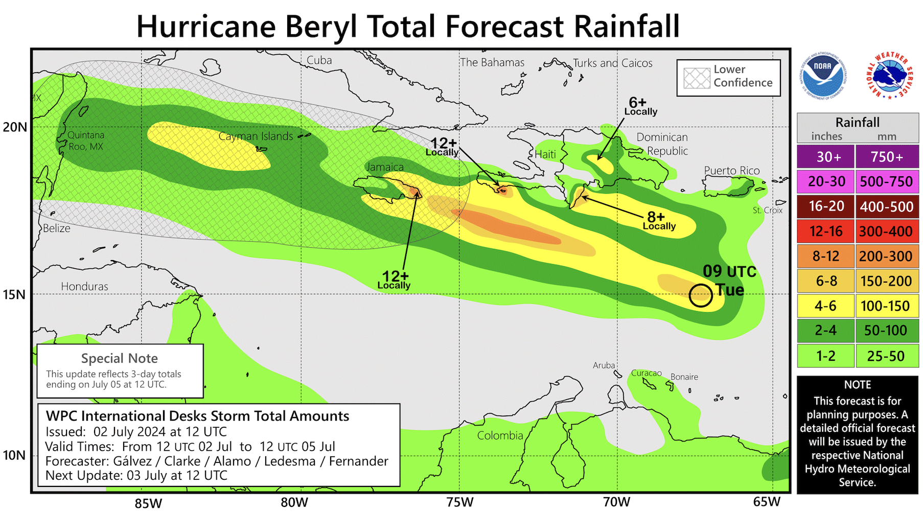
“Tropical storm conditions are expected by late Wednesday night as Hurricane Beryl approaches. Extremely rough seas and storm surges are also forecasted, with swells arriving by Wednesday evening,” it said.
Hazard Management Cayman Islands Education and Communications Officer Simon Boxall, speaking with Mark Lee on Z99FM earlier Tuesday afternoon, said that hurricane shelters across the island are expected to open tomorrow morning.
He said the high seas are expected to adversely affect the southern coast of Grand Cayman starting Wednesday night.
He has advised boat owners to start securing their boats either in dry dock or in the North Sound.
He advised against docking in canals.
Listen to the interview below.

Similar conditions of overcast skies and widespread thunderstorms are expected from Wednesday evening on the Sister Islands.
Tropical storm conditions are expected by Wednesday evening as Hurricane Beryl approaches.
“The proximity of Hurricane Beryl enhances the likelihood of extremely rough seas, significant swells, and storm surges,” the National Weather Service said.
US National Hurricane Center Director Michael Brennan, in a video update on Facebook, said while Beryl remains a Category 4 storm, forecasters will have a “better handle on the intensity forecast” once the storm gets past Jamaica.
He said they will be able to see how much Beryl interacts with the land mass in Jamaica, the increasing vertical wind shear and a less favourable atmospheric environment over the northwestern portion of the Caribbean Sea.
“We’re expecting devastating hurricane-force winds, life-threatening storm surge, damaging waves over portions of Jamaica and the Cayman Islands,” he said.
Hurricane conditions, he said, could be possible in the Cayman Islands from Wednesday night into Thursday morning.
“Residents in these areas should be listening to their local officials and rush any preparations to completion,” he said.
Original story
The Cayman Islands has been placed under a Hurricane Warning as of 1pm Tuesday and all non-essential government offices have been ordered closed from 2pm until an official ‘All Clear’ is given.
This means hurricane-force conditions are likely within the next 36 hours.
The US-based National Hurricane Center warned of “devastating hurricane-force winds, life-threatening storm surge, and damaging waves” in portions of Jamaica and the Cayman Islands by Wednesday and Wednesday night.
Life-threatening flash flooding was expected to impact Jamaica on Wednesday, as Hurricane Beryl approaches the island with maximum sustained winds of 155 mph.
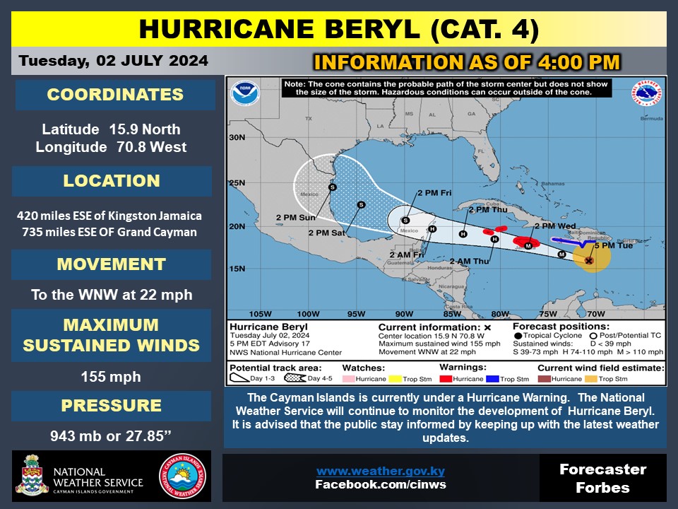
As of 4pm, Hurricane Beryl was located 735 miles east-southeast of Grand Cayman with movement north-northwest at 22 mph.
The Cayman Islands government issued the warning following the advice of acting Deputy Governor Eric Bush, in his role as chairman of the National Hazard Management Council; the director general of the Cayman Islands National Weather Service; and the director of Hazard Management Cayman Islands.
As at 1pm Tuesday, Hurricane Beryl had weakened slightly to a Category 4 storm. Cayman Brac and Little Cayman were likely to be the first to feel the impact of Hurricane Beryl starting as early as Wednesday night.
According to the projected onset of tropical-storm-force winds, Cayman Brac can expect impacts from 9pm Wednesday night, Little Cayman at 9:30pm Wednesday and Grand Cayman at 12:30am on Thursday.
The centre of Hurricane Beryl is expected to pass 41 miles south of Grand Cayman at approximately 5am on Thursday, 4 July. It will also pass 92 miles south of Cayman Brac, and 86 miles south of Little Cayman around the same time on Thursday morning.
The US National Hurricane Center in Miami, in its 1pm advisory, said reports from an Air Force Reserve Hurricane Hunter aircraft indicate that Beryl’s maximum sustained winds are near 155mph with higher gusts.
“Weakening is forecast later today, but Beryl is still expected to be near major hurricane
intensity as it moves into the central Caribbean and passes near Jamaica on Wednesday and the Cayman Islands on Thursday. Additional weakening is expected thereafter, though Beryl is forecast to remain a hurricane in the northwestern Caribbean,” it said.
Hurricane-force winds extend outward up to 40 miles from the centre and tropical-storm-force winds extend outward up to 175 miles.
Expected weather conditions
Overcast skies with widespread thunderstorms are anticipated for Grand Cayman starting Wednesday evening, a government statement said.
“Tropical storm conditions are expected by early Thursday morning as Hurricane Beryl approaches. Extremely rough seas and storm surges are also forecasted, with swells arriving by Wednesday evening,” it added.
Similar conditions of overcast skies and widespread thunderstorms are expected from Wednesday evening over the Sister Islands.

“The proximity of Hurricane Beryl enhances the likelihood of extremely rough seas, significant swells, and storm surges. Adjustments to the forecast track suggest an increased possibility of storm force winds impacting the Sister Islands,” the statement added.
A flood warning is currently in effect for the Cayman Islands, as there is expected to be approximately 4-10 inches of rainfall on Thursday, 4 July.
A marine warning is also in effect, with wave heights expected to rise to 6-9 feet on Wednesday evening, 10-15 feet on Thursday, and 5-7 feet on Friday.
The National Emergency Operations Centre has been activated as of 12pm Tuesday with multiple senior-level government officials including the Cayman Islands Regiment, Fire Service, Royal Cayman Islands Police Service and Coast Guard; and infrastructure partners collaboratively coordinating planning and response activities, the statement said.
“As we prepare for the threat of Hurricane Beryl, we are asking that the public remain highly attentive to all official channels and comply with directions being given. Continued proactive efforts are imperative at this time – secure your homes, have all necessary resources like water, food supplies and medication and assist the vulnerable in your families and communities,” said the acting deputy governor.
The Cayman Islands government called for unified cooperation and awareness ahead of Hurricane Beryl and its potential impact on the Cayman Islands.
The next bulletin will be issued at 6pm Tuesday.
Urgent appeal for O negative and O positive blood
The Cayman Islands Blood Bank has issued an urgent call for donations of O Positive and O Negative blood on Tuesday and Wednesday ahead of the passage of Hurricane Beryl.
“These specific blood types are critically needed to ensure the Blood Bank is prepared for any emergencies that may arise during and after the storm,” a statement from the Health Services Authority stated Tuesday afternoon.
Judith Clarke, Laboratory Manager at the Health Services Authority and Cayman Islands Blood Bank said with the threat of Hurricane Beryl it is important that the Bank’s blood supply is sufficiently stocked.
“We are calling on all eligible donors with O Positive and O Negative blood types to come forward immediately. Your donation could save lives in our community. Together we can ensure that we are prepared for any situation that Hurricane Beryl may bring,” Clarke said.
Donors are reminded to ensure they are well-hydrated and have eaten before donating.
The Blood Bank also encourages donors to spread the word to friends and family who may be eligible to donate.
“We deeply appreciate the generosity of our donors,” Clarke added.
Donations can be made at the Cayman Islands Blood Bank, 2nd Floor George Town Hospital. For more info contact 244-2674/2677.
Parliament postponed
House Speaker Sir Alden McLaughlin has announced the postponement of Friday’s Parliamentary sitting due to the looming approach of Hurricane Beryl.
McLaughlin, in a brief statement Tuesday afternoon, said, new date has not yet been set but “will be announced as soon as is practicable”.
The Parliament, he said, could convene if required in an emergency.
McLaughlin encouraged all residents and visitors to adhere to the guidelines published on caymanprepared.gov.ky as he echoed the sentiments shared by Premier Juliana O’Connor-Connolly and the Government for cooperation.
“I encourage the public not to take anything for granted – prepare, prepare, prepare,” McLaughlin added.
He pointed to several Acts that now exist in the Cayman Islands that address the environment and disaster management, including the Disaster Preparedness and Hazard Management Act (2019) that was first enacted in 2016.
“We have developed rigorous processes since Hurricane Ivan, and effective emergency legislation to manage disasters,” McLaughlin assured.
Actions to Take Now
1. Batten Down: Ensure that your home is secure by reinforcing doors, windows, and any other potential points of entry for wind and water.
2. Finalise Your Emergency Kit: Ensure your emergency kit is stocked with water, non-perishable food, medications, batteries, flashlights, and important documents.
3. Prepare for Shelter: Know the location of the nearest shelter to you in the event you need to seek refuge. Wait for the announcement of the shelter opening.
4. Communicate Plans: Share your emergency plans with family and friends to ensure everyone knows what to do and where to go.
5. Stay Updated: Monitor official channels for real-time information and updates on the hurricane’s progress.
6. Stay Safe: Avoid non-essential travel and stay indoors once the hurricane conditions begin to manifest.
Related Videos


