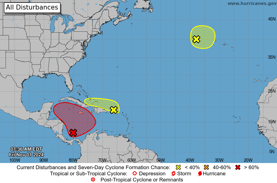
The odds of a named storm forming in the western Caribbean Sea are increasing, with the US National Hurricane Center showing a 70% probability of tropical cyclone development over the next seven days.
If a cyclone forms, it would be called Patty.
The Friday morning National Hurricane Center forecast indicated that, by early next week, a tropical depression could form out of an area of low pressure, that is presently coming together in the southwest Caribbean Sea. If that trend continues, and the cyclone forms, it is expected to begin drifting to the north or northwest.
Most long-range forecast models do not show the area strengthening into a tropical storm or hurricane, so the threat of strong winds impacting the Cayman Islands is considered low at this point.
However, on Friday morning, the Cayman Islands was located within the potential area of development on the National Hurricane Center’s seven-day graphical outlook product.
Regardless of development, locally heavy rains are possible for areas in the western Caribbean region next week.
As of Friday, a so-called ‘invest’ had not yet been announced and no hurricane hunter reconnaissance missions were scheduled.
Meanwhile, Cayman is experiencing “fresh to strong winds accompanied with rough seas”, which Cayman’s National Weather Services says will continue for the next few days, associated with a strong high-pressure system over the western Atlantic Ocean.
Winds over the next 24 hours are expected to be east to northeast at 15 to 20 knots, with higher gusts. Seas will be rough with wave heights of 5 to 7 feet, and small craft are advised to exercise caution over the open seas.
Related Videos


