
The Cayman Islands is located on the Cayman Ridge, on the southern border of the North American tectonic plate, with the Caribbean plate to the south.
These two plates are constantly moving against each other, with the North American plate moving west in a left lateral motion, at a velocity of approximately 19 mm per year.
Potential earthquake sources in the Cayman area include the Mid Cayman Rise (or Cayman Spreading Centre), and the Swan Fracture Zone on its east side, and Oriente Fracture Zone on its west.
These fracture zones represent the southern and northern boundaries of the Cayman Trench.
Two different types of plate interactions take place close to the Cayman Islands:
• A short spreading centre (divergent plate boundary) south and west of George Town, where the two plates pull away from each other causing magma to come up through the divide, which then cools and creates new crust.
• A transform boundary (strike-slip), where the plates slide past each other.
Both of these plate interactions are known to generate earthquakes. There is the potential for the Cayman Islands to be affected by a major earthquake, but the return period (and probability of occurrence) for major quakes in the near proximity of the islands is low.
RECENT SIGNIFICANT EARTHQUAKES NEAR CAYMAN
 Dec. 2004: A 6.8 magnitude event with an epicentre 20 miles south of George Town.
Jan. 2020: A 7.7 magnitude event with the epicentre 80 miles east-southeast of Cayman Brac.
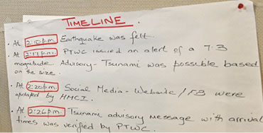
Feb. 2025: A 7.6 magnitude earthquake 126 miles southwest of Grand Cayman triggered a tsunami warning for the islands.
Related Videos


