For the latest information on storm activity in the Cayman Islands, as well as information on how to prepare for hurricane season, visit Storm Centre.
Update 5:00pm Sunday, 25 Sept.:
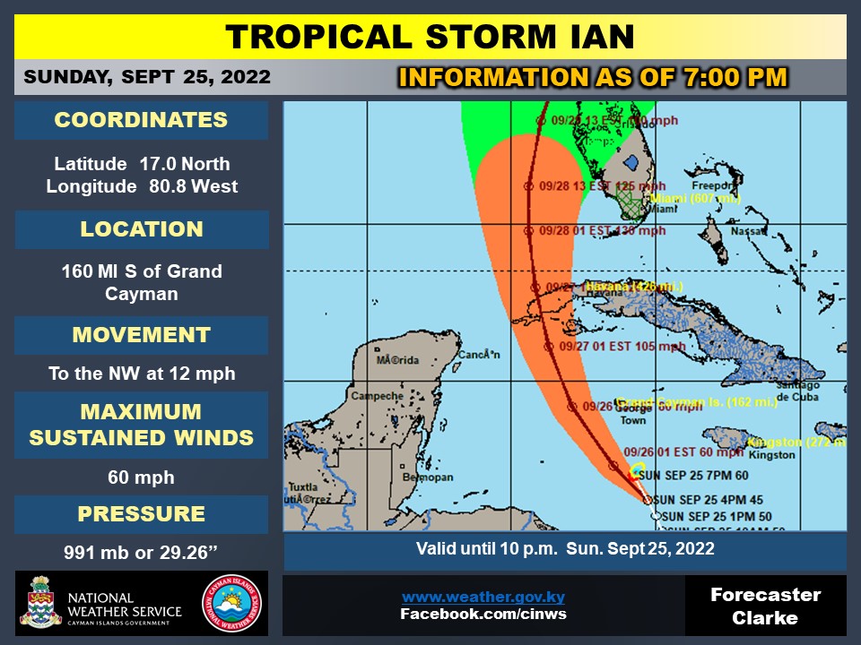
Tropical Storm Ian moved closer to Grand Cayman late Sunday afternoon, although its maximum sustained wind speed had dropped slightly to 45mph, according to the latest forecast from the National Weather Service.
However the Weather Service also forecasts, based on the storm’s latest track, that the closest point of approach will take the centre of the storm closer than previous forecasts – 85 miles south-west of Grand Cayman, at around 8am on Monday.
The onset of tropical storm force winds on Grand Cayman is predicted from 5am Monday morning.
Ian is now moving west-northwest at 12 mph and was situated about 220 miles SSE of Grand Cayman, at 16.2N and 80.3W, according to the 4pm update.
Forecasters anticipate storm force winds will lessen by 3pm on Monday.
Gusts of 20 to 30 mph are expected on Grand Cayman on Sunday evening and 15 to 20 mph with higher gusts on the Sister Islands. This is expected to increase to 40 to 45 mph, with higher gusts, on Monday morning for Grand Cayman and upwards of 20 to 25 mph for the Sister Islands.
In the interim, Grand Cayman will see overcast skies and widespread thunderstorms from Sunday evening. Rough seas, accompanied by storm surge, are anticipated and swells generated by Ian will spread into the Cayman area from Sunday.
A hurricane warning remains in place for Grand Cayman, with a tropical storm watch issued for Cayman Brac and Little Cayman.
Weather in the Sister Islands is also forecast to be overcast with thunderstorms. However, given the adjustments to forecast track, the possibility for storm force winds are lower for the Sister Islands.
Flood and marine warnings are in effect for Cayman.
The latest forecast estimates wave heights of 6 to 8 feet, especially along the south coast for Sunday and 9 to 12 feet on Monday, particularly along the south and west coasts.
Update: 1:20pm Sunday 25 Sept.:
Forecasters sounded an optimistic note, Sunday afternoon as Tropical Storm Ian continued to drift to the west, raising hopes that Cayman could suffer a glancing blow rather than a direct hit from the developing weather system.
Despite the shift in the forecast track, with the eye of the storm now expected to pass around 100 miles from Grand Cayman, there remains potential for “rapid intensification”. It could be a “strong hurricane” by the time it passes the islands, bringing high winds and surging seas.
Grand Cayman remains under a Hurricane Warning and the Sister Islands remain under a Tropical Storm Watch.
Deputy Governor Franz Manderson, chair of the National Emergency Operations Centre, warned that the threat posed by the storm remains high.
He said, “Though Tropical Storm Ian seems to be moving away from the Cayman Islands in a favourable direction at this time, its potential to impact all three islands remains a very real possibility that everyone must be prepared for.
“This system is expected to bring heavy rainfall, winds and large waves at our coastlines so we must remain vigilant.”
Though the level of threat to Cayman Brac and Little Cayman has receded with the new forecast, he said the tropical storm watch remained in place out of an abundance of caution.
“This system cannot be underestimated and I trust the people of the Cayman Islands to continue their preparedness activities and take all necessary precautions. Please, stay off the roads and away from beaches until the All Clear has been given. The safety of our people is paramount at this time”.
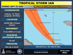
As at 10am, Tropical Storm Ian was located at 15.2N and 79.8W or about 300 miles SSE of Grand Cayman, with maximum sustained winds of 50 mph. Tropical Storm Ian is moving towards west-northwest at 14 mph with minimum central pressure of 1001mb / 29.59 inches.
Director of the National Weather Service John Tibbetts said there was still a risk that the storm could shift track or intensify.
“The continued changes to the storm means the forecast uncertainty remains high and there remains the possibility of rapid intensification. I advise the public to continue their preparedness activities and to remain vigilant until an All Clear is given.”
Overcast skies with widespread thunderstorms are expected from Sunday evening with tropical storm conditions by early Monday morning as the system nears the Cayman Islands. Extremely rough seas accompanied by storm surge are also expected. Swells generated by Tropical Storm Ian will spread into the Cayman area later tonight, the forecast projects.
Potential impact includes flooding that could lead to roadways becoming inaccessible, projectiles due to strong winds, and damage to coastal areas most affected by heavy waves. The Cayman Islands are expected to receive up to two inches of rainfall later today, and an additional two to four inches Monday. Waves are expected to rise to six to eight feet today especially along the south coast of Grand Cayman. Swells of 5 to 7 feet are likely along with 1 to 3 feet of storm surge.
Update: 11:20am Sunday 25 Sept.: Grand Cayman remains under a Hurricane Warning as of 10am Sunday, while government has reissued the Tropical Storm Watch for Little Cayman and Cayman Brac, as the islands brace for Ian’s arrival.
In its 10am bulletin, The Cayman Islands National Weather Service (NWS) said Tropical Storm Ian was located 300 miles south southeast of Grand Cayman with maximum sustained winds of 50 miles per hour.
The storm’s speed has increased slightly and is now moving towards the west north west at 14 miles per hour, with minimum central pressure of 1001mb / 29.59 inches.
The US National Hurricane Center said the storm is expected to intensify rapidly later Sunday, with tropical storm conditions set to begin affecting Grand Cayman Sunday night.
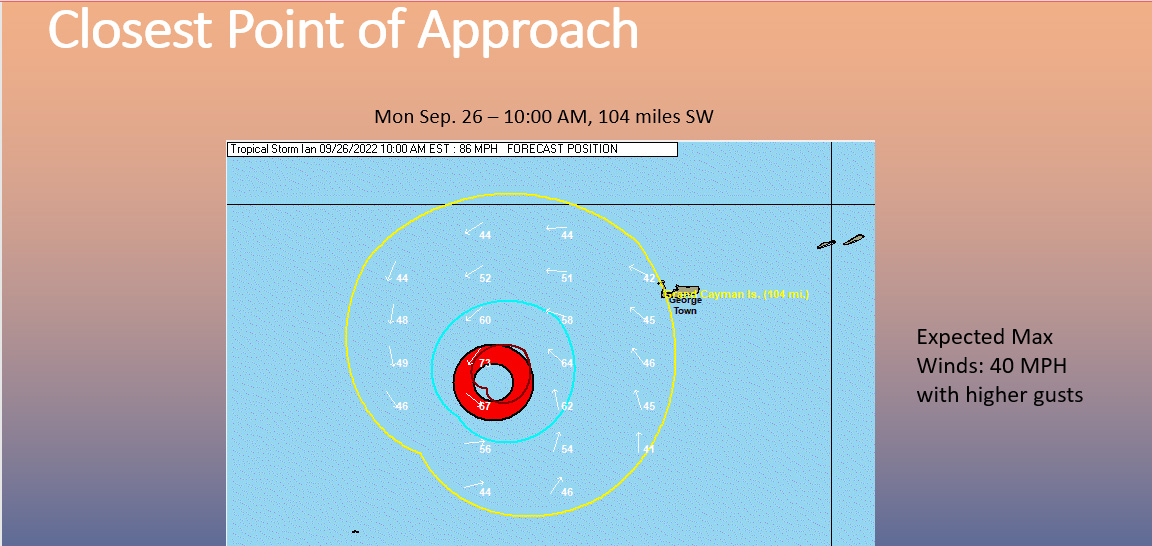
Based on the current track, the closest point of approach will be the center at 104 miles southwest of Grand Cayman on Monday at 10am.
The onset of tropical storm force winds for Grand Cayman is now expected to be at 8am Monday, per the latest NWS briefing, ending at 1pm.
A marine warning is in effect and all marine craft should seek and remains in safe habour, the NWS said.
For Grand Cayman, NWS said, “Overcast skies with widespread thunderstorms are expected from Sunday evening with tropical storm conditions by early Monday morning as the system nears the Cayman Islands. Extremely rough seas accompanied by storm surge are also expected. Swells generated by Ian will spread into the Cayman area later today.”
The NWS forecast for the Sister Islands: “Overcast skies along with widespread thunderstorms are expected from Sunday evening as Tropical Storm Ian moves closer to the Cayman Islands. Extremely rough seas along with swells and storm surges are also expected. Given the adjustments to forecast track the possibility for storm force winds are lower for the Sister Islands.”
Update 8am Sunday 25 Sept.: Ian was about 320 miles south southeast of Grand Cayman as at 8am.
Grand Cayman remains under a Hurricane Warning, while the Sister Islands are under a tropical storm watch. A hurricane warning means hurricane conditions are expected somewhere in the warning area. A tropical storm watch means tropical storm conditions are possible within the area.
Hurricane conditions are expected to reach Grand Cayman by early Monday.
Tropical storm conditions are possible on Little Cayman and Cayman Brac by tonight or early Monday, the NHC said in its 8am bulletin.
The NHC said swells generated by Ian are affecting Jamaica and will spread to the Cayman Islands later on Sunday.
“Swells will then spread northwestward to the southwestern coast of Cuba and the coasts of Honduras, Belize, and the Yucatan Peninsula of Mexico Monday and Monday night. These swells are likely to cause life-threatening surf and rip current conditions,” it added.
Ian is expected to become a Category One hurricane as it nears the Cayman Islands and is moving toward the west-northwest near 12 miles per hour with maximum sustained winds near 50 miles per hour with higher gusts.
Based on the latest track (4am)
The Onset of Tropical Storm Force Winds for:
· Grand Cayman is: Mon Sep-26, 4:00 AM
The closest point of approach:
· Center is 99 miles SW of Grand Cayman: Mon Sep-26, 8:00 AM
End of Tropical Storm force winds for:
· Grand Cayman is: Mon Sep-26, 3:00 PM
Tropical-storm-force winds are extending outward up to 60 miles (95 km) from the center.
“Rapid strengthening is forecast to begin later today. Ian is expected to become a hurricane later [Sunday or Sunday night] and reach major hurricane strength by late Monday or Monday night before it reaches western Cuba,” it said.
A turn toward the northwest at a similar forward speed of near 12 miles per hour is expected later Sunday, followed by a turn toward the north-northwest on Monday and north on Tuesday.
“On the forecast track, the center of Ian is forecast to pass well southwest of Jamaica today, and pass near or west of the Cayman Islands early Monday. Ian will then move near or over western Cuba Monday night and early Tuesday and emerge over the southeastern Gulf of Mexico on Tuesday,” the NHC added.
Storm surge could raise water levels by as much as 2 to 4 feet above normal tide levels along the immediate coast in areas of onshore winds in the Cayman Islands Sunday night into Monday.

Extremely rough seas accompanied by storm surge are also expected.
Tropical Storm Ian is expected to produce the between 3 to 6 inches, with local maximum of up to 8 inches rain, the NHC bulletin stated.
The closest point of approach is predicted to be 99 miles southwest of Grand Cayman at 8am Monday, Cayman Islands National Weather Service (NWS) said in its 4am update.
Weather conditions are expected to begin deteriorating within the next 24 hours, the NWS said in its 9am update.
Overcast skies with widespread thunderstorms are expected today, with tropical storm conditions late into the night and possible hurricane conditions early Monday morning as the system nears the Cayman Islands.
As the system moves more west of the Cayman Islands, tropical storm force winds with possible hurricane force gusts are expected for Grand Cayman by early Monday morning. The Sister Islands are expected to experience similar conditions, but have a lower chance of experiencing storm force winds based on the current forecast track.
Marine warnings are in effect for the Cayman Islands, with anticipated wave heights of six to eight feet, and storm surge of two to four feet.
Forecasts show two to four inches of rainfall over the next 72 hours, thus triggering flood warnings for the Cayman Islands. Persons living in low-lying areas are strongly encouraged to seek shelter on higher ground.
The estimated minimum central pressure is 1001 mb (29.56 inches) based on NOAA Hurricane Hunter dropsonde data.
The storm is expected to become a major hurricane by late Monday before it reaches western Cuba.
A hurricane watch is in effect for the Cuban provinces of Isla de Juventud, Pinar del Rio, and Artemis.

Shelters
Hazard Management Cayman Islands has said hurricane shelters/emergency medical centres will be open to the public on Sunday 25 Sept.
The following hurricane shelters have been activated and open Sunday at 2pm:
o Sir John A. Cumber Primary School
o John Gray High School (Pet friendly)
o Bodden Town Primary School
o Clifton Hunter High School (Pet friendly)
o East End Civic Centre
o Cayman Islands Red Cross Building (opens at 4pm)
Each of the six shelters, with exception of the Red Cross Building, also serves as a designated Emergency Medical Centre.
The Aston Rutty Civic Centre in Cayman Brac will be open as an emergency shelter at 8am Sunday.
“Additional shelters activations across all three islands will be announced as needed, depending on the intensity and forecasted track of the tropical cyclone,” HMCI added in a post on its Facebook page.
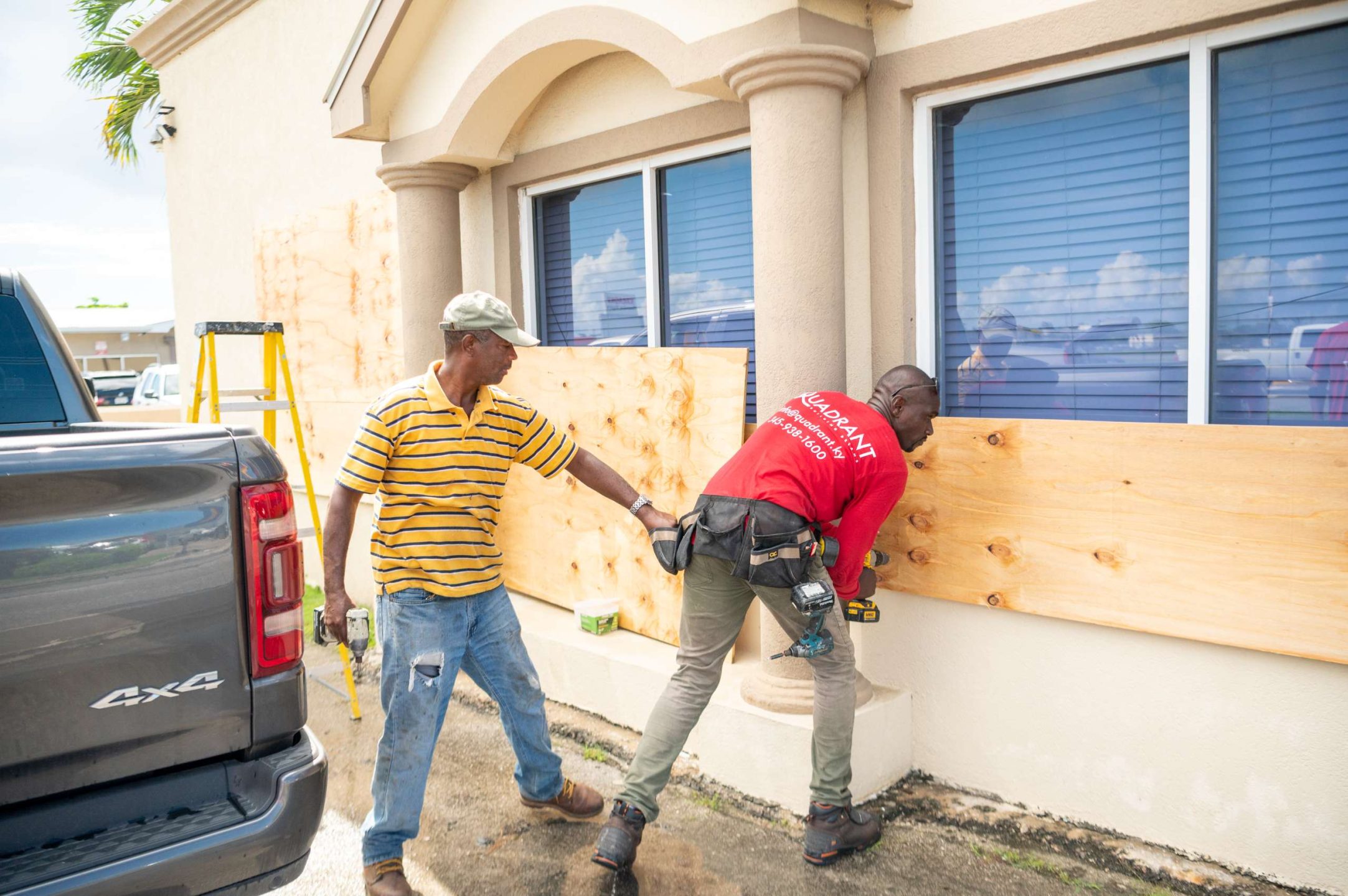
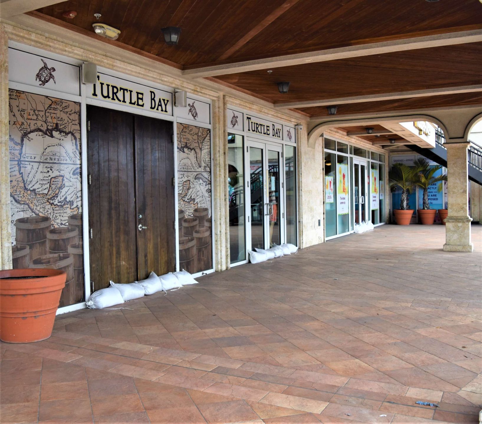
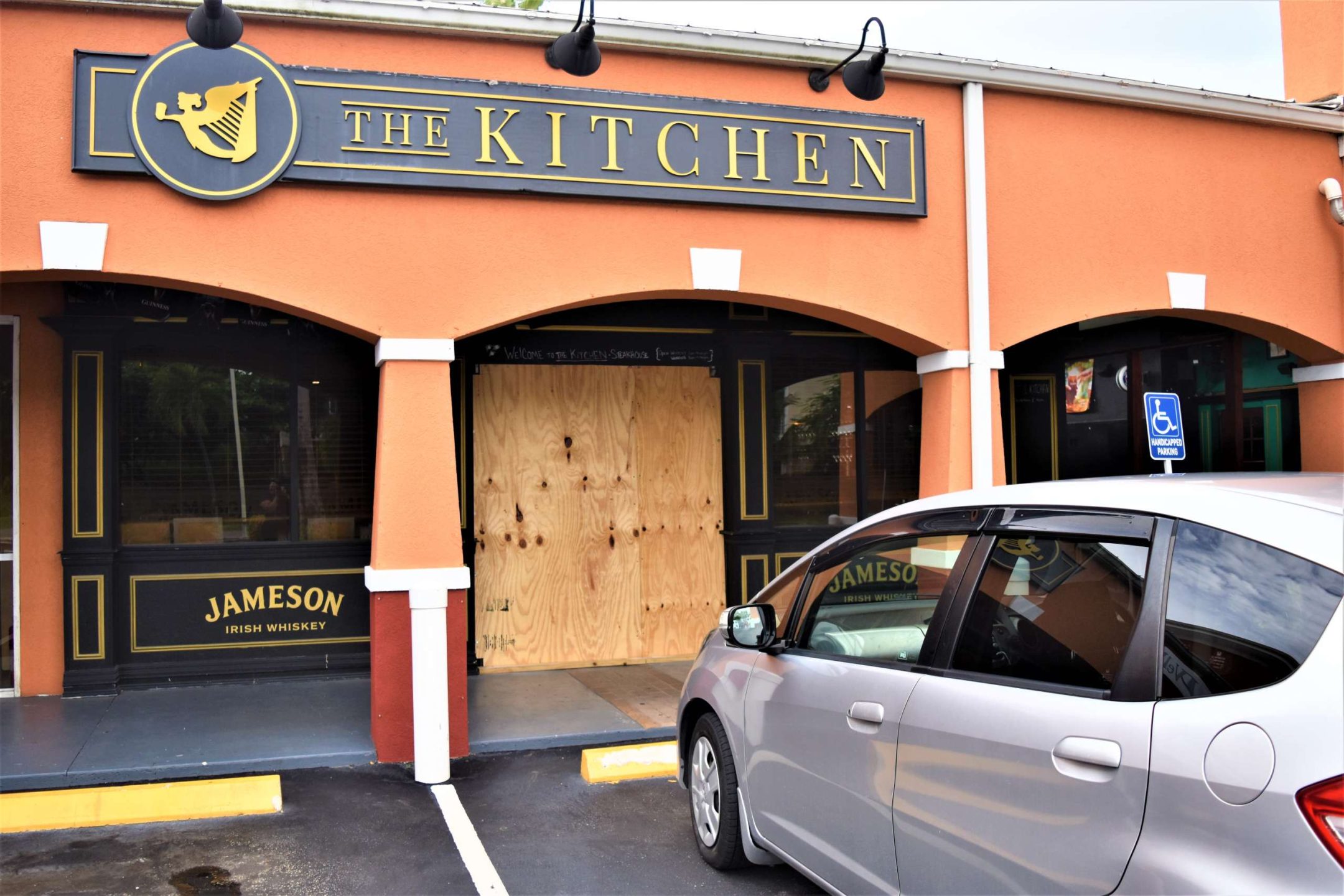
Due the continued unpredictability of Tropical Storm Ian and its expected intensification, Cayman residents are urged to remain cautious and prepared.
Persons attending shelters are reminded to bring adequate food, water and personal hygiene supplies with them.
They should also have all important documentation in their possession and stored in a watertight container.
Persons who require special assistance should be accompanied by a caregiver.
Related Videos


