
2024 was a stormy year for the Cayman Islands. There were several impactful nor’westers, two tropical weather systems that brought torrential rain and a direct hit from a hurricane, along with a number of near misses from cyclones.
“2024 felt like a stormy year in many respects,” said Hazard Management Cayman Islands Director Dani Coleman.
“While some of these storms caused structural damage to properties, damaged docks and eroded parts of Seven Mile Beach, there were no lives lost in 2024 in storms or hurricanes, so for that we are, of course, extremely grateful.”
Overall, the 2024 Atlantic hurricane season came in below early seasonal forecasts, but it was still highly active with 18 named storms, 11 hurricanes and five major hurricanes.
AccuWeather chief meteorologist Jon Porter wrote, “The 2024 hurricane season will be remembered for shattering records and causing approximately US$500 [billion] in total damage and economic loss … this turned out to be an explosive, supercharged hurricane season that was fueled by extremely warm water temperatures linked to climate change.”
According to Justin Roth, associate director of catastrophe analytics R&D at Howden Re., projections indicate that “2024 will rank as the second-costliest hurricane season on record”.
The National Oceanographic and Atmospheric Administration’s National Centers for Environmental Information also said “2024 was almost certain to end as the world’s warmest year on record”.
“Year after year, the climate crisis continues to break new records, resulting in more extreme weather events, including rapidly intensifying tropical cyclones, intense rainfall and flooding,” said World Meteorological Organization Secretary-General Celeste Saulo.
February nor’wester
In February, the Cayman Islands National Weather Service began issuing severe weather bulletins for a strong cold front approaching the Cayman Islands.
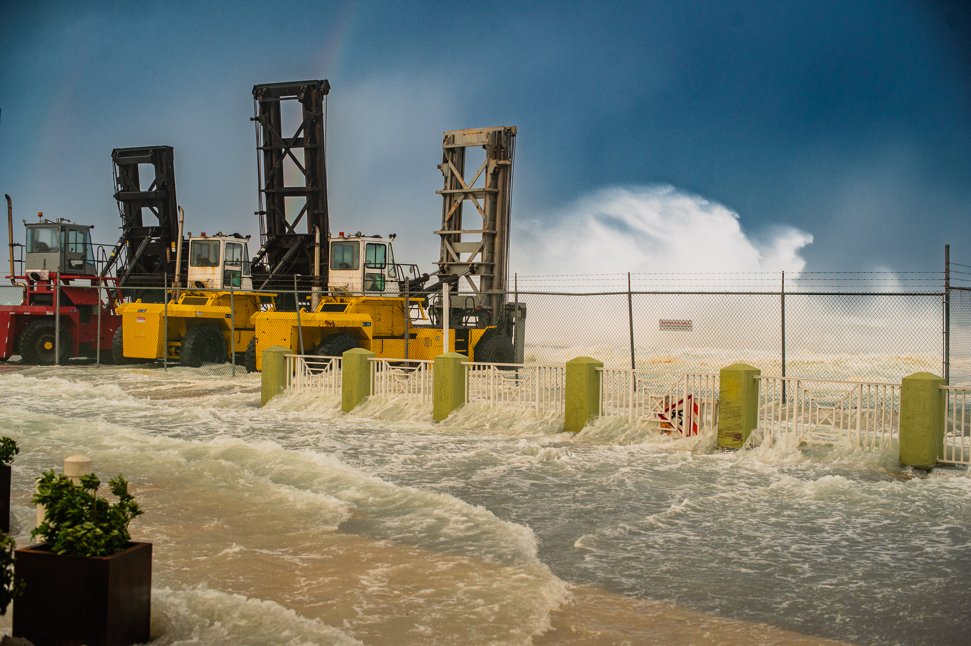
This nor’wester arrived on 6 Feb., bringing gale-force winds and 15-to-16-foot waves to the Cayman Islands. It swept cars out of parking lots along North West Point Road and South Church Street, and closed coastal roads along stretches of the west side of Grand Cayman. Sunset House, Macabuca and Vivo restaurants were all damaged by the waves and had to close for extended periods of time for repairs.
In Cayman Brac, the same storm damaged the port building, and debris covered the roads in parts of Watering Place and Spot Bay.
June deluge
On 10 June, torrential rainfall associated with a tropical disturbance was so exceptional that the National Emergency Operations Centre was partially activated, the regiment was mobilised, and emergency shelters were opened.
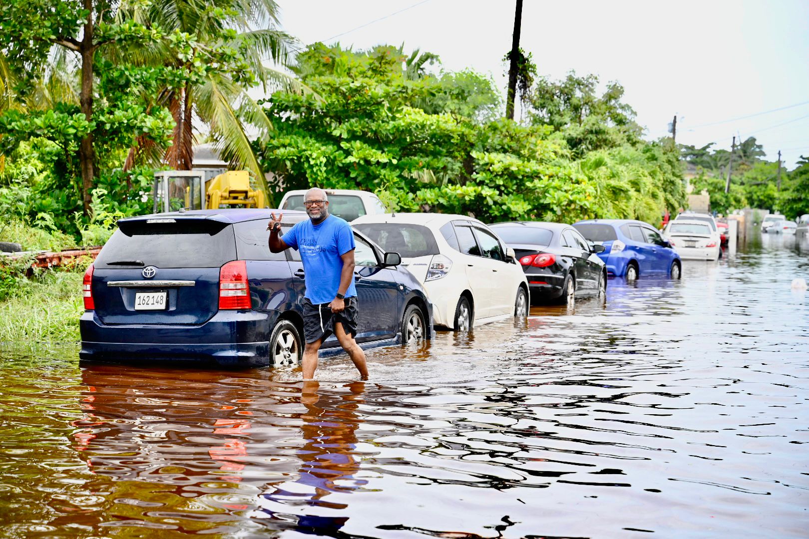
Numerous roads became impassable in the deluge, including parts of Linford Pierson Highway, and flood waters entered some homes in areas like Windsor Park and off Eastern Avenue.
Hurricane Beryl
On 1 July, the Cayman Islands was located inside the US National Hurricane Center tracking cone for Beryl, forecast to pass the Cayman Islands as a powerful Category 5 hurricane with sustained winds of 160 mph.
Over the next two days, Hurricane Beryl weakened slightly as it approached, but was still a formidable Category 4 hurricane with 145 mph winds. At 1pm on 3 July, emergency shelters were activated across all three Cayman Islands, and government buildings closed. Residents were advised to shelter in place from 6pm, and by 7pm, conditions started to deteriorate with the hurricane now located just 215 miles away from Grand Cayman.
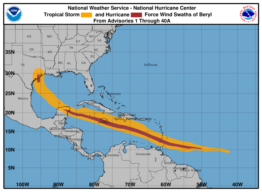
On 4 July, Hurricane Beryl passed 50 miles southwest of Grand Cayman at its closest point of approach. Fortunately, Beryl had weakened slightly to a Category 3 hurricane as it passed, but strong tropical-storm-force winds were experienced on all three islands.
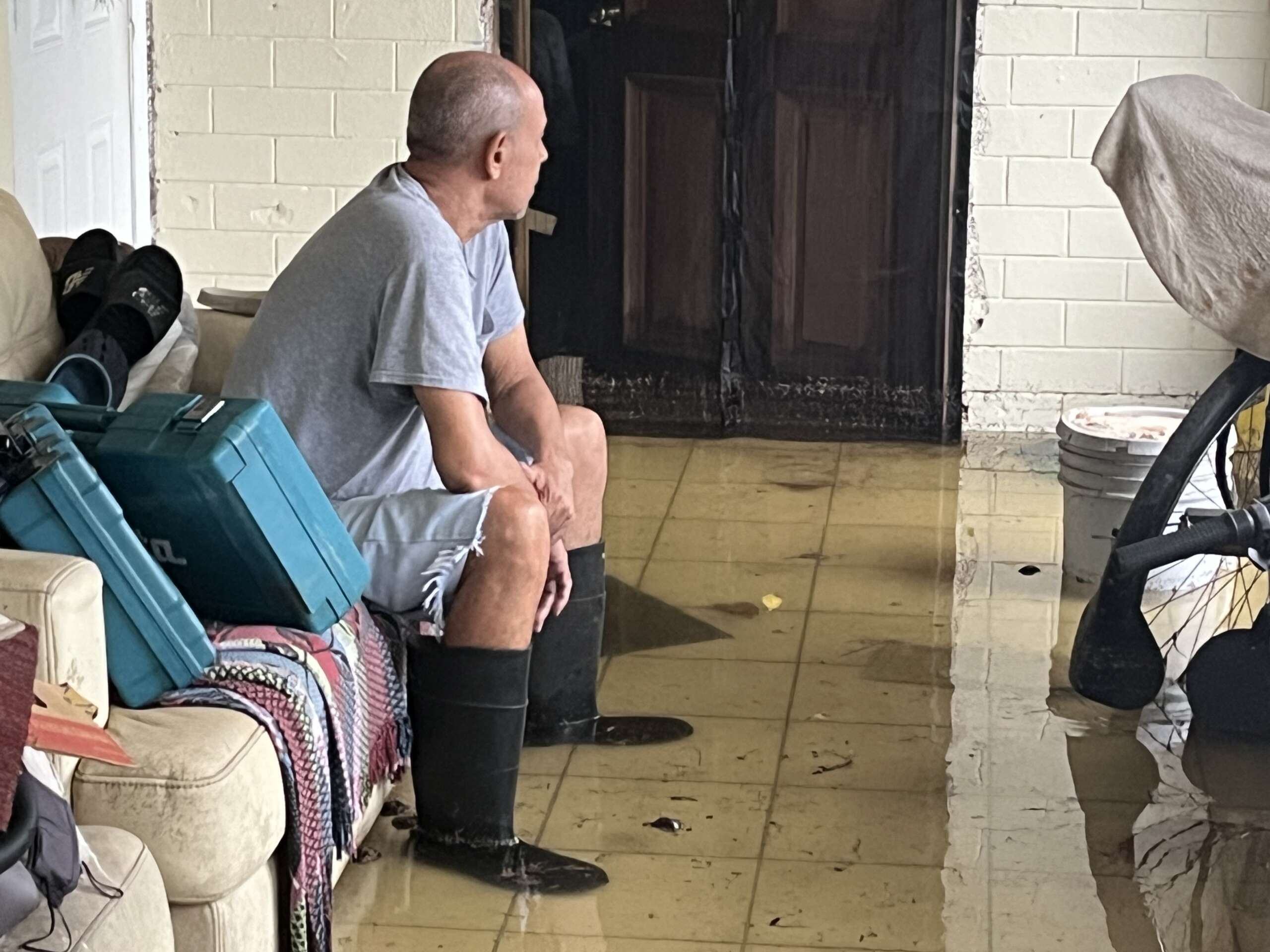
Beryl brought widespread flooding to Grand Cayman, downed power lines and toppled trees. The extremely rough waves did significant damage to some of the seafront units at Windsor Village and a number of other properties. It also damaged docks and caused substantial erosion on Seven Mile Beach.
Hurricane Beryl subsequently went into the record books as the earliest Atlantic basin Category 5 hurricane on record.
Hurricane Helene
On 20 Sept., the Cayman Islands National Weather Service began issuing warnings for a broad area of disturbed weather that was expected to bring very heavy rainfall and rough seas to the Cayman Islands from late on 22 Sept.
Several homes were flooded in the rain associated with this disturbance, which started as a broad area of low pressure near the Cayman Islands. The storm was accompanied by torrential rains, which continued for the next three days, causing schools to close. Airport operations also ceased on 25 Sept.
This disturbance eventually strengthened into Hurricane Helene, which later went into the history books as the strongest hurricane on record to strike the Big Bend area of Florida, hitting 140mph at landfall, and the deadliest hurricane since Hurricane Maria in 2017.
Helene caused more than 230 fatalities across the southeastern United States and billions of dollars’ worth of damage.
Hurricane Milton
On 2 Oct., the Cayman Islands National Weather Service began issuing flood advisories for a tropical disturbance in the western Caribbean Sea. While the system did not prove to be a wind threat to the Cayman Islands, as it moved away from Cayman and into the Gulf of Mexico, it gradually strengthened into a hurricane on 6 Oct.
On 7 Oct., Hurricane Milton underwent a period of explosive intensification, becoming a Category 5 hurricane with wind speeds of 180 mph. Milton’s rate of rapid intensification is among the highest ever observed, with a 90-mile-per-hour increase in wind speed during the 24-hour period from early 6 Oct. to early 7 Oct.
Despite being hundreds of miles away, and tracking across the Gulf of Mexico, Hurricane Milton still influenced weather conditions in the Cayman Islands, with large waves crashing ashore on the west side of Grand Cayman, undermining part of the sea wall at Coral Beach and also at the nearby Royal Palms on Seven Mile Beach.
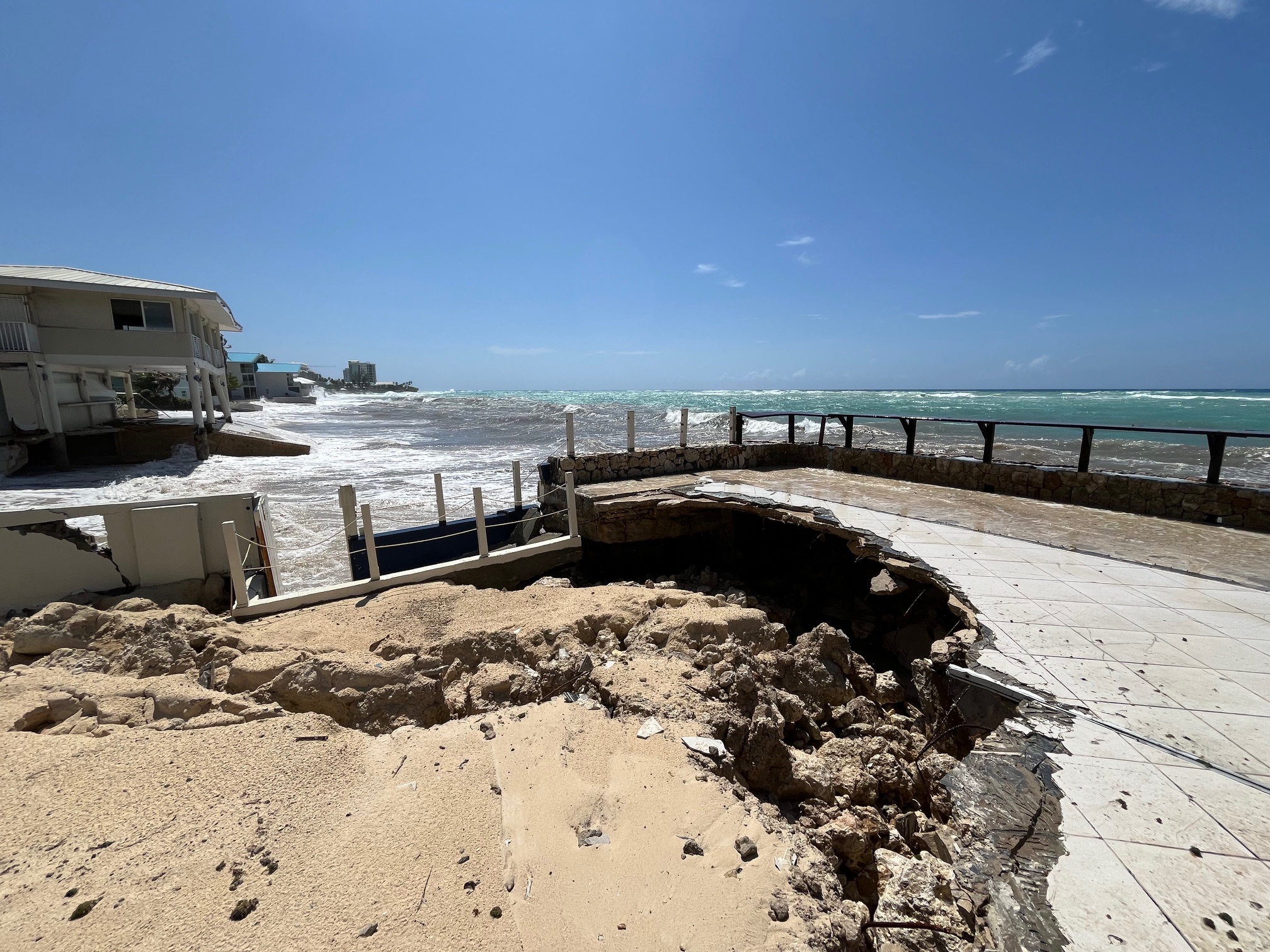
The waves and debris associated with Hurricane Milton forced the closure of Seafarers Way between Warwick Drive and Fort Street to motorists on 9 Oct., with the Royal Cayman Islands Police Service advising that conditions along the roadway were “extremely unsafe”.
Wind shear weakened the hurricane as it approached western Florida; however, Hurricane Milton caused an estimated US$85 billion in damage and resulted in 35 fatalities.
Hurricane Rafael
On 2 Nov., the Cayman Islands National Weather Service issued a severe weather alert ahead of the possible formation of a tropical depression in the southwest Caribbean. “Significant” rainfall was anticipated across the Cayman Islands, the alert stated.
The following day, at 4:30pm on 3 Nov., the Cayman Islands was placed under a ‘Hurricane Watch’ with the tropical depression located about 500 miles southeast of the Sister Islands and moving northeast at 6 mph.
On 4 Nov., the Cayman Islands was placed under a ‘Hurricane Warning’, meaning tropical-storm-force winds were imminent. By 4pm, the depression strengthened into Tropical Storm Rafael and airports closed on all three islands, along with schools and government offices.
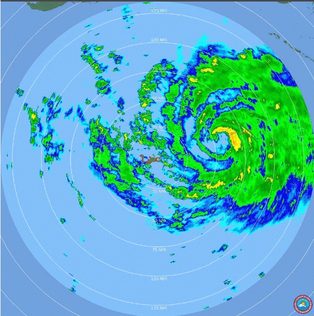
Around 7pm on 5 Nov., the eye wall of Hurricane Rafael began impacting the western end of Little Cayman, with the centre of Hurricane Rafael passing a few miles away from the western tip of the island.
High winds, rough waves and sea surge brought by the hurricane knocked out power to the island, sunk dive boats, damaged docks, ripped the roofs off at least two buildings, and caused various levels of damage to several properties on Little Cayman, including to the hotels. The steeple also blew off the Little Cayman Baptist Church, and fallen trees and utility poles blocked the road along parts of the south coast of the island.
More than 100 tourists rode out the hurricane on Little Cayman and with torrential rain still lashing the island the following day, the runway remained closed. Hotels had to scramble and improvise to feed and accommodate the visitors, despite not having electricity and while trying to clean up from the effects of the hurricane. The visitors were finally able to leave on the evacuation flights on 7 Nov., two days after hurricane.
Despite the impact from Hurricane Rafael, utilities were restored to most of Little Cayman by 9 Nov. and roads were quickly cleared of debris with the support of the regiment, which deployed to Little Cayman to assist with the recovery.
Takeaways from 2024
Reflecting on the storms of 2024, HMCI Director Dani Coleman said, “We were impacted by a number of significant rainfall events and these torrential rains caused homes to flood and led to school closures and shelter activations.
“Perhaps the most important takeaway from our experiences in 2024 is that we need to focus more attention on flooding, and work with our partners to find ways to further mitigate this hazard.”
Related Videos


