
Editor’s note: Simon Boxall previously worked at Hazard Management Cayman Islands, where he was listed as the designated tsunami scientific advisor for the Cayman Islands by a UNESCO commission.
The threat of a significant tsunami wave impacting the Cayman Islands is low but not zero, according to regional experts.
The islands were placed under a tsunami alert on Saturday following the magnitude 7.6 earthquake, 126 miles southwest of Grand Cayman, at a depth of 6.2 miles.
The quake – the largest in the world since 2023 – and the tsunami warning that followed made headlines around the globe.
Soon after the initial notification, residents located near coastal areas were advised to move inland and to higher ground, in response to the potential threat of a 1-to-3-foot tsunami.
Anxiety spread within and beyond Cayman’s shores. WhatsApp messages pinged frantically.
Posts on social media showed there was some confusion in the community about where to go, whether the threat was real, and if it was even possible for Cayman to be impacted by a tsunami.
So what was the real threat level?
Before joining the Compass, and while working at Hazard Management Cayman Islands, I was listed as the designated tsunami scientific advisor for the Cayman Islands by a UNESCO commission.
As one of the tsunami warning focal points, it was part of my job to receive the tsunami alert messages from the Pacific Tsunami Warning Center and help to ensure the information was swiftly disseminated to residents when there was an impending threat.
I’ve probably spent more hours than anyone else in these islands thinking and asking questions about earthquakes and tsunamis around Cayman. Most of what I learned is reassuring.
The tsunami threat to the Cayman Islands is slim. But it does exist.
It is possible that we even experienced a minor tsunami – literally defined as a wave caused by the displacement of water, typically following an earthquake – on Saturday.
Unfortunately, the tsunami sensor located in George Town harbour is not currently working or transmitting data.
The only regional sensor that detected a tsunami wave from the weekend’s event was in Islas Mujeras, Mexico, recorded at 0.1 feet, or 1.2 inches.
Perhaps we experienced similar and didn’t notice.
In January 2020, the tsunami sensor in George Town recorded an 18-inch wave when a 7.7 magnitude earthquake, 80 miles southeast of Cayman Brac, shook the islands.
The possibility of a more serious tsunami impacting the Cayman Islands became clearer in 2023, when Diego Arcas, tsunami modeller from the National Oceanographic and Atmospheric Administration (NOAA) Center for Tsunami Research, presented the results of a tsunami inundation study of the Cayman Islands.
His key finding:
“The Cayman Islands are not one of the locations more exposed to the risk of tsunamis compared to other parts of the Caribbean, but there is a risk of a very near field event. That is a very real risk and that type of event would definitely affect the islands.”
In simple terms, what he is saying is that if there was a similarly large earthquake very close to the Cayman Islands, then yes, it could generate a significant tsunami wave.

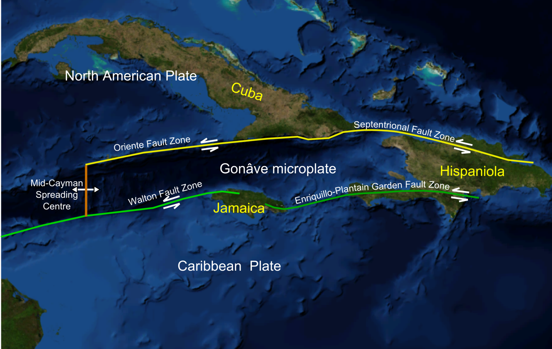
Almost all of the seismic activity around Cayman that we feel is caused by the movement of the Caribbean and North American tectonic plates.
The Oriente fault, which separates the two plates in the region south of the Cayman Islands, also runs south of Cuba and curves westward between Jamaica and the Cayman Islands.
At its closest points, the fault line hits around 25 miles south of Cayman.
Arcas modelled tsunami waves that could be generated by 39 of the most likely source locations for huge earthquakes, not just along that fault nearest to the Cayman Islands, but also for regional locations, like in the Eastern Caribbean Sea subduction zone.
He also modelled the waves that were generated in the Great Lisbon Earthquake of 1755 to analyse the effects of the tsunami waves on Cayman.
He looked at, and modelled, all of the very large seismic events from the most likely locations that could trigger a tsunami, possibly affecting the Cayman Islands.
Worst-case scenarios
He explained that if the same 7.7 magnitude event that occurred in 2020 was moved down the Oriente transform fault line, until it was positioned directly below the Cayman Islands, it could be a much-bigger problem.
The model showed that a tsunami would occur in that scenario, and that it could impact the Cayman Islands. However, he noted, the probability of such an event is very low.
The data from that exercise is not currently public, so we can only speculate about the threat level.
What seems obvious is that a tsunami wave – if one were generated in those circumstances – would be upon us in a matter of minutes.
It is worth remembering that this is an absolute worst-case scenario intended for risk-management planning. But it is important that the work on the Cayman Islands risk modelling continues, despite the recent announcement that the US will de-fund its main sponsor, USAID.
And while the Cayman Islands was fortunate to receive the completed NOAA tsunami model, the work on the NOAA storm surge and hurricane wave impact inundation model was still in progress and was expected to be completed in 2025.
Hurricane storm surge is the number one threat to life and property in the Cayman Islands.
What size waves could be generated?
Exactly how big a tsunami wave could be generated is something that the model – once public – may also help us determine.
Following the 2020 quake, Diego Melgar, a tsunami expert at the University of Oregon, told the Compass the type of plate activity on the Oriente fault is something that works in Cayman’s favour in this respect.
“From a lateral fault event you will never see the type of gigantic tsunamis like the 30-metre wave in Japan [in 2011],” he said.
That doesn’t mean Cayman couldn’t suffer a severe tsunami wave impact. He estimates up to around 3 metres (10 feet) is possible.
“There is always the added hazard of underwater landslides which are hard to predict and can impact wave action,” Melgar said.
Tsunami watch partnerships
Within NOAA and partner organisations there is a whole team of people trying to keep us as well informed as possible to enable us to be prepared in the unlikely event of a worst-case scenario.
Christa Von Hillebrant-Andrade, manager of the NOAA Caribbean Tsunami Information Center who joined Dr Arcas in presenting the results of the Cayman Islands tsunami inundation study, helps to ensure information about a possible tsunami gets to those who need it swiftly.
Part of her job is to ensure that the national contacts and tsunami warning focal points in the Cayman Islands, which include Hazard Management Cayman Islands, the Cayman Islands National Weather Service and the Department of Public Safety Communications, receive the alerts from the Pacific Tsunami Warning Center in Hawaii, so they can be disseminated in a timely way to residents when a threat of tsunami exists.
The NOAA Caribbean Tsunami Information Center office, which she leads, is also responsible for producing ‘Caribe Wave’, the world’s largest tsunami exercise which occurs annually in March.
This year one of the two scenarios will involve a magnitude 8 earthquake event occurring near Jamaica. HMCI Director Danielle Coleman has confirmed that the agency will be participating again this year.
The Cayman Islands National Weather Service is the recognised authority for all seismic matters in the Islands, and their functions include “establishing and maintaining a national network of seismic stations, issuing tsunami warnings and advising the Governor in Cabinet on all matters relating to seismic activity”.
Related Videos


Not surprising the tsunami sensor is George Town Harbor is working. With frequency of earthquakes and destruction of the islands mangrove can Hazard Management formally provide an evacuation guide on what to do or where to go in a tsunami similarly like the hurricane guide. Lots of seniors like myself don’t know. Also there were no emergency information provided on radio cayman after the event, why is this?
It seems the Cayman Islands Weather Service have problems with their technical systems. The radar is regularly out of action and now we hear the tsunami sensor is not working. I wonder how long the sensor has been inoperative.
Anything is possible depending on how a fault slips, in which direction at what intensity and depth, but the Cayman Islands is at the top of a spire and similar to Diego Garcia in the Indian Ocean which remained largely unaffected during the Aceh quake in Indonesia while Somali (behind it) suffered a dmaaging tsunami, Grand Cayman is generally speaking, blessed, with tremendous geological siting that would spare us from the classic type of Tsunami they experienced in Japan. Nothing to get complacent about but unlikely any of us will need to retreat to the top of a tall building in all but the most unusual of circumstances.