
Forecasters have upgraded their projections for one of two weather systems being closely monitored in the Atlantic basin, giving it a 40% chance of development through this week.
The National Hurricane Center in Miami, in its afternoon report, said additional development of this system is possible during the next several days as it moves generally west-northwestward at about 20 miles per hour.
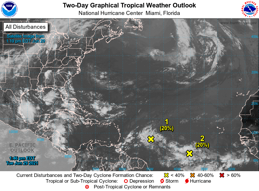
“Shower activity associated with a tropical wave located about 900 miles southwest of the Cabo Verde Islands continues to show signs of organization,” it said.
The system is forecast to have a 20% formation chance through 48 hours and 40% through five days.
A second system, which has been on the radar for a couple of days, has shifted its track slightly and is now shown overlapping with the system southwest of Cabo Verde.
The chance of formation of this system, the NHC said, has dropped from 40% to 30% through five days.
“Disorganized showers and thunderstorms continue in association with a tropical wave located over the tropical Atlantic about 650 miles east of the Lesser Antilles. Some slow development of this disturbance is possible later this week while the system moves
westward to west-northwestward at 20 to 25 mph, likely reaching the Lesser Antilles by Wednesday night,” the NHC said.
Regardless of development, this system could bring locally heavy rainfall to portions of the Lesser Antilles during the next few days, the NHC said.
Original story: Both US and Cayman forecasters are keeping close watch over two weather systems producing showery activity in the tropical Atlantic, both of which have a chance of further development later this week.
The first system, located about 850 miles east of the Lesser Antilles, is projected to likely reach that island chain by Wednesday night, the National Hurricane Center in Miami said in its Tuesday morning report.
“Disorganized showers and thunderstorms continue in association with a tropical wave located over the tropical Atlantic,” it stated, adding, “some slow development of this disturbance is possible later this week and this weekend while the system moves westward to west-northwestward at 15 to 20 miles per hour.”
The NHC has given the system a 30% chance of formation through 48 hours and a medium chance of formation (40%) through the next five days.
National Weather Service meteorologist Avalon Porter said he is anticipating this system to impact the islands on Monday, 5 July.
Residents, he said, can expect conditions – based on current projections – to be “cloudy at times with a 50% chance of showers and thunder. Winds will be east to southeast at 15 to 20 knots. Seas will be rough with wave heights of 4 to 6 feet.”
Porter said this is the first time he has seen such a lengthy track like the one projected for this system, adding it is being fuelled by the high pressure system to the north which is keeping the system on a westerly track.
Meanwhile, a second system has emerged on the radar which will overlap with the system near the Lesser Antilles, based on existing forecast tracks.
The NHC, in its report Tuesday, said shower activity associated with a tropical wave located about 800 miles southwest of the Cabo Verde islands has become a little better organised since yesterday.
“Additional slow development of this system is possible during the next several days as it moves generally west-northwestward at about 20 mph,” it added.
The NHC has given this system a low chance of formation – 10% through 48 hours and 20% through five days.
Related Videos


