
Forecasters are monitoring a weather system in the southwestern Atlantic Ocean, which is likely to develop into Hurricane Bonnie, which would make it the first hurricane of the 2022 season.
It poses no immediate threat to the Cayman Islands.
If the system maintains its projected path, it is expected to develop into a tropical storm near the southern Windward Islands or while moving westward across the southern Caribbean sea over the next day or two. On this path, it is likely to develop into a Category 1 hurricane on Saturday.
According to the National Hurricane Center in Miami, Florida, as of 8am Tuesday, the system maintained its tropical depression status and was generating strong winds and heavy rainfall a couple of hundred miles southeast of the Windward Islands.
“Winds to tropical-storm-force are expected over portions of the southern Windward Islands tonight,” reads the National Hurricane Center’s weather bulletin.
It adds, “Tropical storm conditions are possible along the northeastern coast of Venezuela tonight and Wednesday, and Bonaire by Wednesday evening.”
If the storm develops as predicted, it would be the second named system of the 2022 Atlantic hurricane season, which began on 1 June. On 5 June, Tropical Strom Alex developed in the Gulf of Mexico, then for the next nine days travelled in a general easterly direction, generating flooding across western Cuba and south Florida.
According to the NHC, if the system develops into a hurricane, that would likely occur around 2am Saturday, off the Caribbean coast of Nicaragua. The Cayman Islands is not in the initial storm path.
In anticipation of the oncoming weather, tropical storm warnings have been issued in Venezuela’s Islas de Margarita, Coche and Cubagua, as well as in Trinidad and Tobago, Grenada, Bonaire, Curacao and Aruba. These warnings mean that tropical storm conditions are expected somewhere within the area within 36 hours.
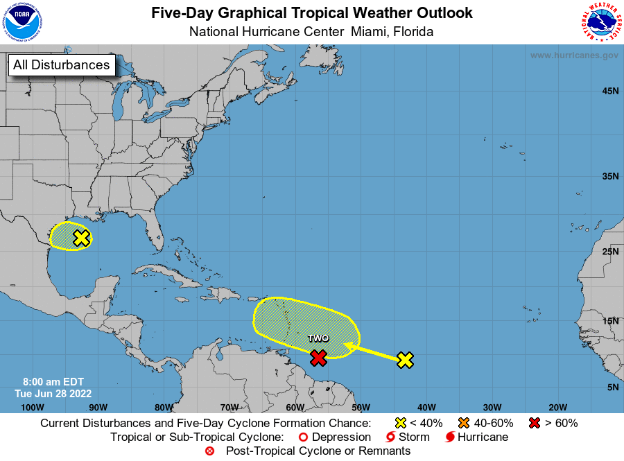
Two other systems being monitored
Two other weather systems are also being monitored by the NHC.
The first is located in the Gulf of Mexico, off the coasts of Texas and Louisiana. Forecasters say it has a 30% chance of further development within the next 48 hours.
“Regardless of the development, heavy rain will be possible along portions of the Texas coast later this week,” reads the NHC bulletin.
Further east, in the western Atlantic, behind potential tropical storm Bonnie, a third system continues to strengthen.
“This system is forecast to interact with another tropical wave to its east over the next several days, and some gradual development is possible later this week while the overall system moves west-northwest at around 15mph across the central tropical Atlantic.”
Related Videos


