
For the latest information on storm activity in the Cayman Islands, as well as information on how to prepare for hurricane season, visit Storm Centre.
Update: 10pm, Sunday 30 Oct. – The Cayman Islands can expect scattered showers with embedded thunderstorms from Tuesday evening as slow strengthening is expected for potential Tropical Cyclone 15 through Monday, the National Weather Service has said.
The NWS, in its 10pm update, said the system could become a tropical storm later Sunday night or on Monday.
A faster rate of strengthening is then expected to start from Monday night, it added.
From Tuesday, winds are expected to be east to northeast at 20 to 25 knots with gusts up to 30 knots. Seas are expected to be 6 to 8 feet with 4 foot swells from Tuesday evening.

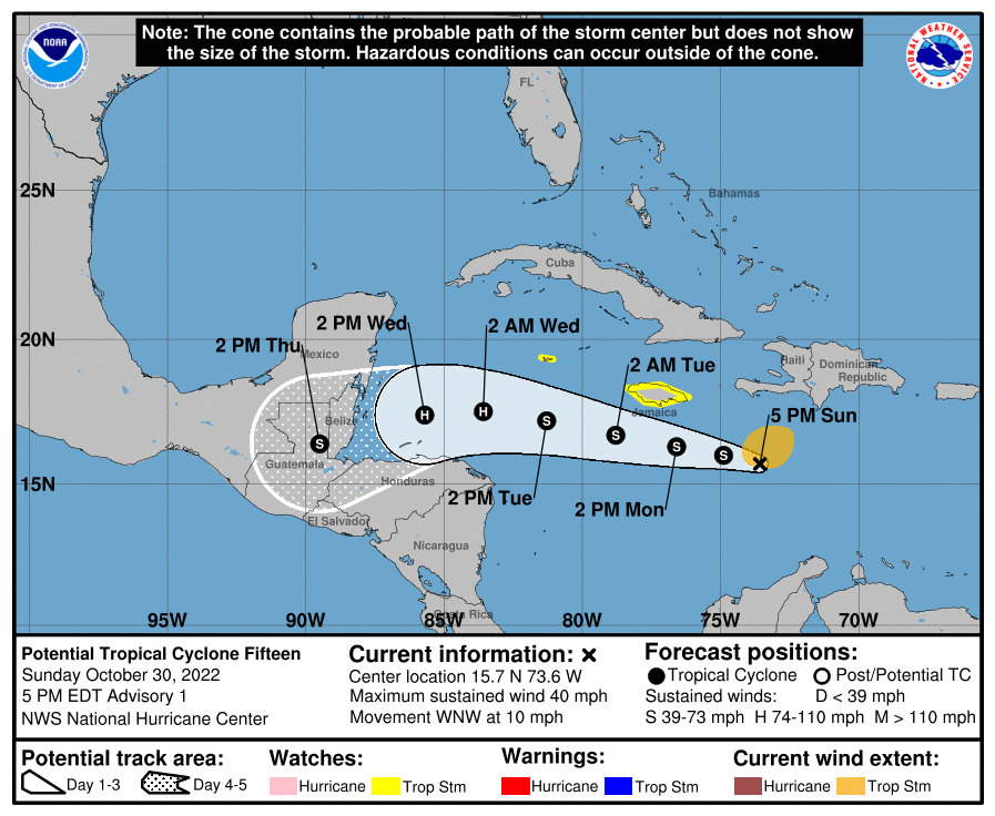
4pm, Sunday 30 Oct.- The Cayman Islands was placed under a ‘Tropical Storm Watch’ on Sunday, 30 Oct., following the development of potential Tropical Cyclone 15, currently located 560 miles east-southeast of Grand Cayman.
On its present forecast track, the weather system is expected to pass 130 miles south of Grand Cayman, according to a statement from Deputy Governor and Chair of the Hazard Management Council Franz Manderson.
The watch, which means tropical storm conditions are possible within the watch area – generally within 48 hours – was issued at 4pm Sunday and applies to all three islands.
In a 5pm advisory Sunday, the US National Hurricane Center in Miami said tropical storm conditions are possible within the watch area in Jamaica beginning late Monday and in Grand Cayman on Tuesday.
Manderson, in the statement, encouraged the community to closely monitor the ongoing developments of this system and stressed the need to prepare.
“Though this system is still evolving, it is with an abundance of caution that we have issued this Tropical Storm Watch. We continue to monitor Potential Tropical Cyclone 15 to ensure that both the Government and the public are able to respond quickly and appropriately to keep the preservation of life at the forefront of our planned response. I encourage everyone to stay abreast of official updates and to action your preparation plans accordingly,” he said.
At 4pm, the centre of potential Tropical Cyclone 15 was located near latitude 15.7 ° north and longitude 73.6° west.
In a 5pm advisory, the NHC said the system is moving toward the west-northwest near 10 miles per hour, and this motion is expected to continue over the next several days, with a gradual turn to the west by Tuesday night.
“Maximum sustained winds are near 40 mph with higher gusts. Strengthening is forecast during the next 48 hours, and the system is expected to become a tropical storm tonight, and it could be near hurricane intensity by Tuesday night,” the NHC said.
Tropical-storm-force winds extend outward up to 115 miles (185 km) from the centre.
Through Wednesday afternoon, the system is expected to produce rainfall amounts of 1 inch, with local amounts to 2 inches across portions of the Cayman Islands, the US Virgin Islands, Puerto Rico, Hispaniola, northern Honduras, eastern Nicaragua, and Belize, the NHC said.
For Jamaica, 2 inches of rainfall with local amounts of 4 inches are expected.
Swells generated by the system are expected to affect Jamaica and the Cayman Islands during the next couple of days. The swells could cause life-threatening surf and rip current conditions.
Related Videos


