
For the latest information on storm activity in the Cayman Islands, as well as information on how to prepare for hurricane season, visit Storm Centre.
Forecasters say a system in the Central Atlantic basin is likely to become a tropical depression over the next day or so as conditions become more favourable for its development.
The system poses no threat to the Cayman Islands.
It is located about midway between the Lesser Antilles and the Cabo Verde Islands.
The US National Hurricane Center, in its Thursday afternoon advisory, said showers and thunderstorms show some organisation in association with the broad low pressure area.
“Environmental conditions are expected to be conducive for additional development,
and this system is very likely to become a tropical depression during the next day or so while it moves west-northwestward to northwestward at 10 to 15 mph across the central tropical Atlantic,” the advisory stated.
Forecasters have given the system a 90% chance of formation in the next 48 hours or through the next seven days.
Lee continues northern track
Meanwhile, Hurricane Lee is still churning in the North Atlantic as a Category 1 storm and it is projected to send tropical storm conditions Bermuda’s way Thursday evening.
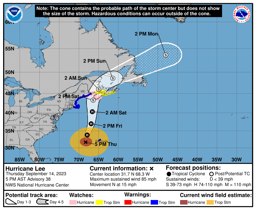
Hurricane Lee is moving toward the north at nearly 15 miles per hour. An increase in forward speed is expected through Saturday, and a turn toward the north-northeast and then northeast is forecast Saturday night and Sunday.
“On the forecast track, the center of Lee will pass west of Bermuda through this evening, approach the coast of New England and Atlantic Canada Friday and Saturday, and move
across Atlantic Canada Saturday night and Sunday,” the NHC said in its advisory on Lee.
Maximum sustained winds are near 85 miles per hour with higher gusts.
Little change in strength is expected through Friday afternoon, the NHC said, with some gradual weakening forecast Friday night and Saturday.
“Lee is expected to remain large and dangerous for the next couple of days. Lee is a large hurricane. Hurricane-force winds extend outward up to 105 miles from the center and tropical-storm-force winds extend outward up to 345 miles. A sustained wind of 40 mile per hour with a gust to 52 miles per hour was recently reported at the L.F. Wade International Airport on Bermuda,” the NHC advisory said.
Hurricane Margot
Also in the Atlantic is Hurricane Margot, which is moving toward the northeast at almost 5 miles per hour, but the storm is expected to slow down as it undergoes a clockwise loop well to the west of the Azores.
Maximum sustained winds are about 80 miler per hour, with higher gusts. Some weakening is forecast during the next 48 hours, and Margot should weaken to a tropical storm by Saturday, the NHC said.
Related Videos


