
Newly published data predicts that the Cayman Islands will lose 32 square kilometres of coastal land due to climate change-induced sea-level rise before the end of the century.
Projections suggest that with moderate global greenhouse gas emissions, about 12% of the territory’s total landmass, which is currently about 264 sq km, will become flooded.
The hyperlocal insights come from Human Climate Horizons – a collaboration between the United Nations Development Programme and the Climate Impact Lab.
On its public online platform, interactive maps and tables show both sea-level and temperature projections, along with the associated impacts on human development.
Users can alter the potential emissions levels and time horizon to see how environmental decisions taken now can shape the future of over 5,000 coastal region populations.
Hannah Hess, associate director at the Climate Impact Lab research body, insisted the projections are not foregone conclusions, but can instead be a catalyst for action.
“Swift and sustained action to reduce emissions will affect how quickly and how much coastal communities are impacted,” she said on the release of the data.
“Reducing emissions not only mitigates risk but buys us more time to proactively respond and prepare for rising seas.”
Cayman on climate
As a small tri-island territory with a mostly low-lying, flat landscape, the Cayman Islands is particularly vulnerable to sea-level rise.
This has led the government to draft two climate-change policies over the past 15 years – but neither have been passed in Cabinet to date.
In September 2011, following a three-year consultation, the government published its first draft Cayman Islands Climate Change Policy.
It set out a five-year action plan to safeguard marine resources, energy security, water resources, food security, critical infrastructure, and the tourism and finance sectors.
Although never passed, some of the policy’s proposals were achieved, such as the adoption of the National Energy Policy and the passage of the National Conservation Act (2013).
A decade later, in 2021, the government commissioned a climate-change risk assessment as a precursor to an updated policy. The report was published in January this year.
The document highlighted sea-level rise as one of the most important physical climate-change impacts.
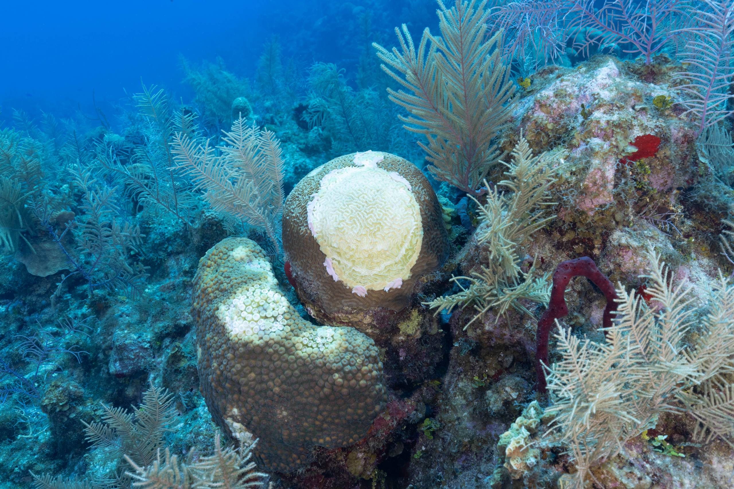
In the natural environment, it said, this could contribute to coral bleaching and disease, loss of mangroves and seagrass, freshwater lens contraction, and habitat destruction.
It could also damage manmade infrastructure such as the sewerage system, roads and airports as well as coastal settlements and buildings.
A new draft Cayman Islands Climate Change Policy 2023-2040 was published in the spring and a two-month public consultation period followed, which concluded on 30 June.
A ministry spokesperson told the Compass this week, that prior to the change of administration, Cabinet had been presented with a revised draft of the policy.
It will now be shared with the new United People’s Movement government and the ministry will incorporate any further suggestions before taking it back to Cabinet for approval.
James Whittaker, president of the Cayman Renewable Energy Association, told the Compass the latest sea-level data illustrates, yet again, that “time is not a luxury we have”.
“We must take bold steps today to mitigate the effects of climate change or the Cayman we want for our children will simply not exist.”
He stressed that only immediate aggressive climate action can ensure future generations are protected.
“Climate change does not care about our politics, stakeholder interests, or opinions and we must act accordingly,” he said.
Future projections
The Human Climate Horizons’ interactive data platform projected the future sea-level rise around Cayman based on an intermediate level of emissions.
This means that countries globally are carrying out their current policies, resulting in a best-estimate global warming of about a 2.7-degree Celsius rise by 2100.
From 2020-2039, the sea level will rise 11.73 centimetres; during the mid-century, 2040-2059, it will rise by 25.1 cm; and in 2080-2099 by 56.33 cm, the data says.

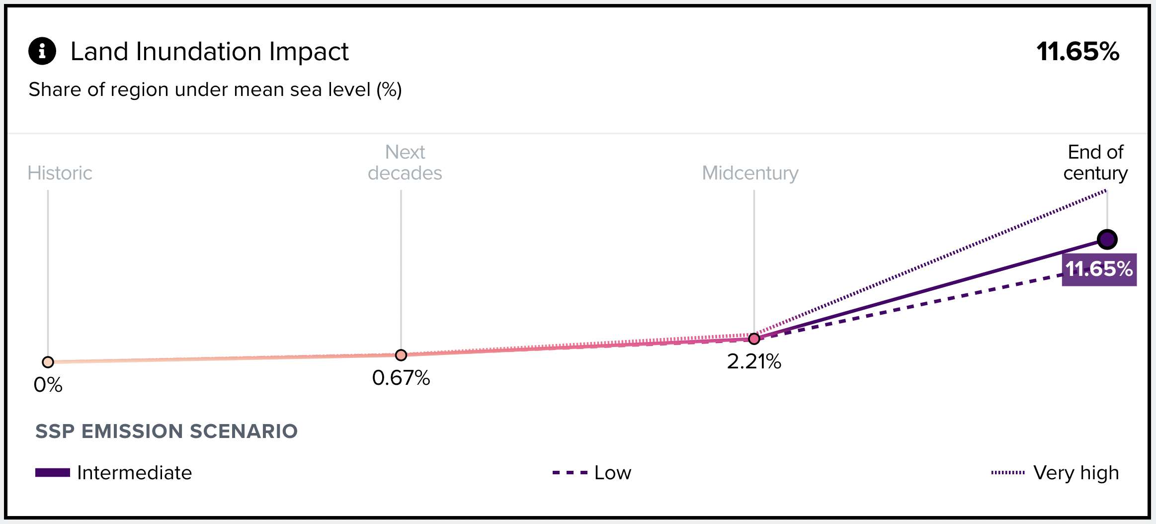
This will see 1.8 sq km of Cayman’s landmass become flooded during 2020-2039, 6.1 sq km during 2040-2059; and 31.9 sq km by the end of the century, from 2080-2099.
The data also details how much of the population will be impacted by flooding, or ‘living in a 1-in-20-year floodplain’.
In 2020-2039 it is just 0.6%, but that rises to 1.48% in 2040-2059 and 4.96% by the end of the century in 2080-2099.
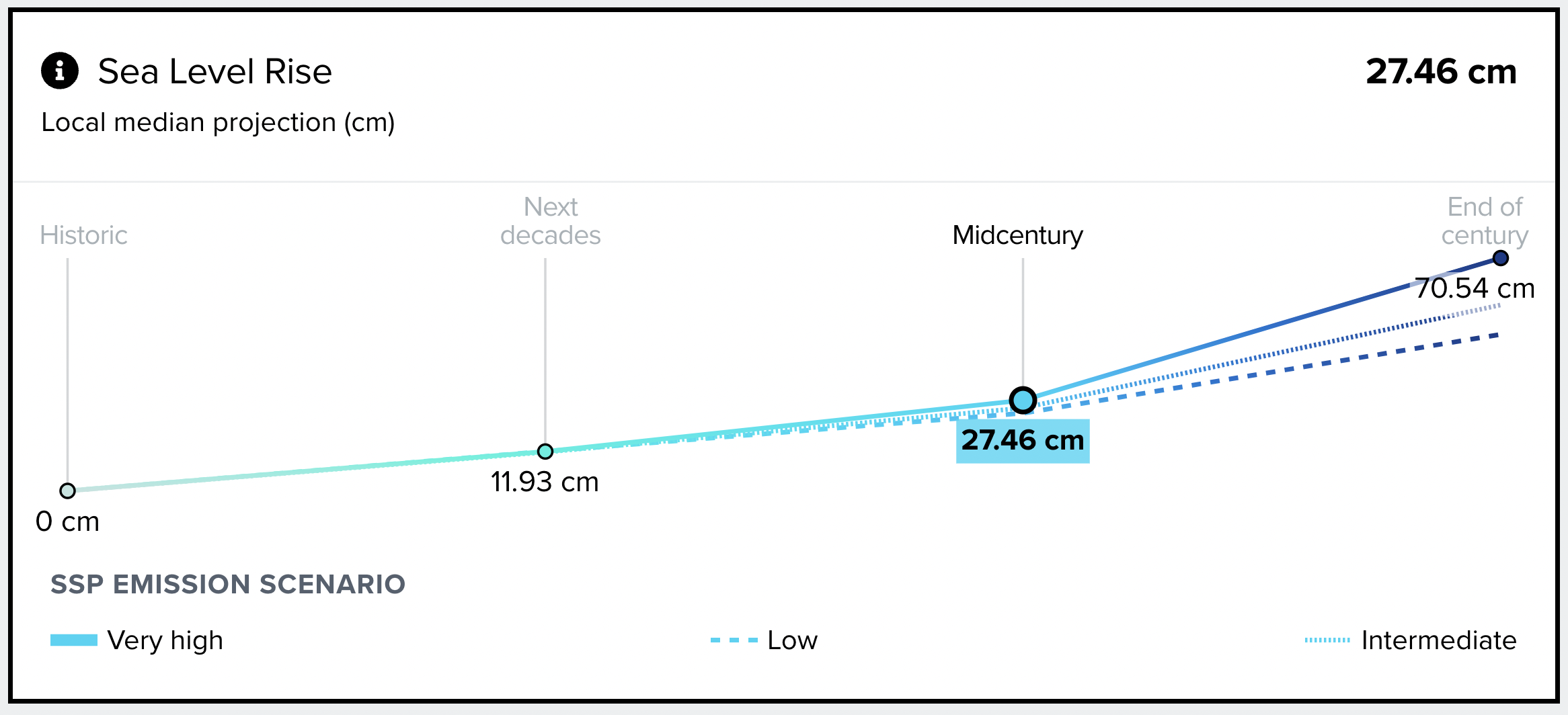
When looking at future sea-level rise around Cayman based on a very high level of emissions, the results are even more dramatic.
In this category, emissions would continue to increase at the same pace as during the first decade of this century, resulting in global warming of about 4.4 degrees Celsius by 2100.
Between 2020-2039 the sea-level will rise 11.93 centimetres, during the mid-century, 2040-2059, it will rise by 27.46 cm, and in 2080-2099 by 70.54 cm, the data says.
This will see 2 sq km of Cayman’s landmass become flooded over 2020-2039, 7.2 sq km during 2040-2059 and 44.7 sq km by the end of the century.
The percentage of Cayman’s population ‘living in a 1-in-20-year floodplain’ would be 0.64% in 2020-2039, 1.66% in 2040-2059 and 7.31% by 2080-2099.
When a low level of emissions is selected on the platform – when global warming is predicted to stay below 2 degrees Celsius – sea-level rise is far less extreme.
‘Profound impact’
Simon Boxall, climate change lead for Hazard Management Cayman Islands, told the Compass that the projected sea-level rise would have a profound impact on Cayman.

“Even a rise of a few inches can have a pronounced effect,” he said, adding that Cayman is, on average, just seven feet above sea level.
He stressed that flooding is a “complex issue” which can be triggered by storm surge, storm-driven waves and rainfall while being influenced by tides and sea-level rise.
Boxall suggested that failure to appropriately factor hazard and flooding risks into the development planning processes could result in a catalogue of future problems.
These could include damage to properties and businesses from hurricanes, long-duration outages of utilities, and growing insurance-affordability issues.
He said floods could also cause increasing public health threats from waterborne microbes and pathogens as well as increase breeding areas for mosquitos.
The flood risk cannot be fully eliminated, according to Boxall, so Cayman must find a level that is acceptable in the context of the visions and goals of the people.
Understanding risk
Hazard Management Cayman Islands works on the theory that development policies should be informed by an evidence-based and scientific understanding of risk, Boxall said.
He explained that “secure, credible and scientific” flood-risk assessments are either taking place or due to take place in the areas of storm surge, storm-driven waves, and tsunami.
Meanwhile, work still needs to be done to model flood risk for the threats of rainfall, tides, incremental sea-level rise, and other factors, he said.
This data will then be used to inform Cayman’s national development plan, building codes and planning laws.
“It is probable that the flood threats cannot really be understood without a more detailed geological study”, Boxall added.
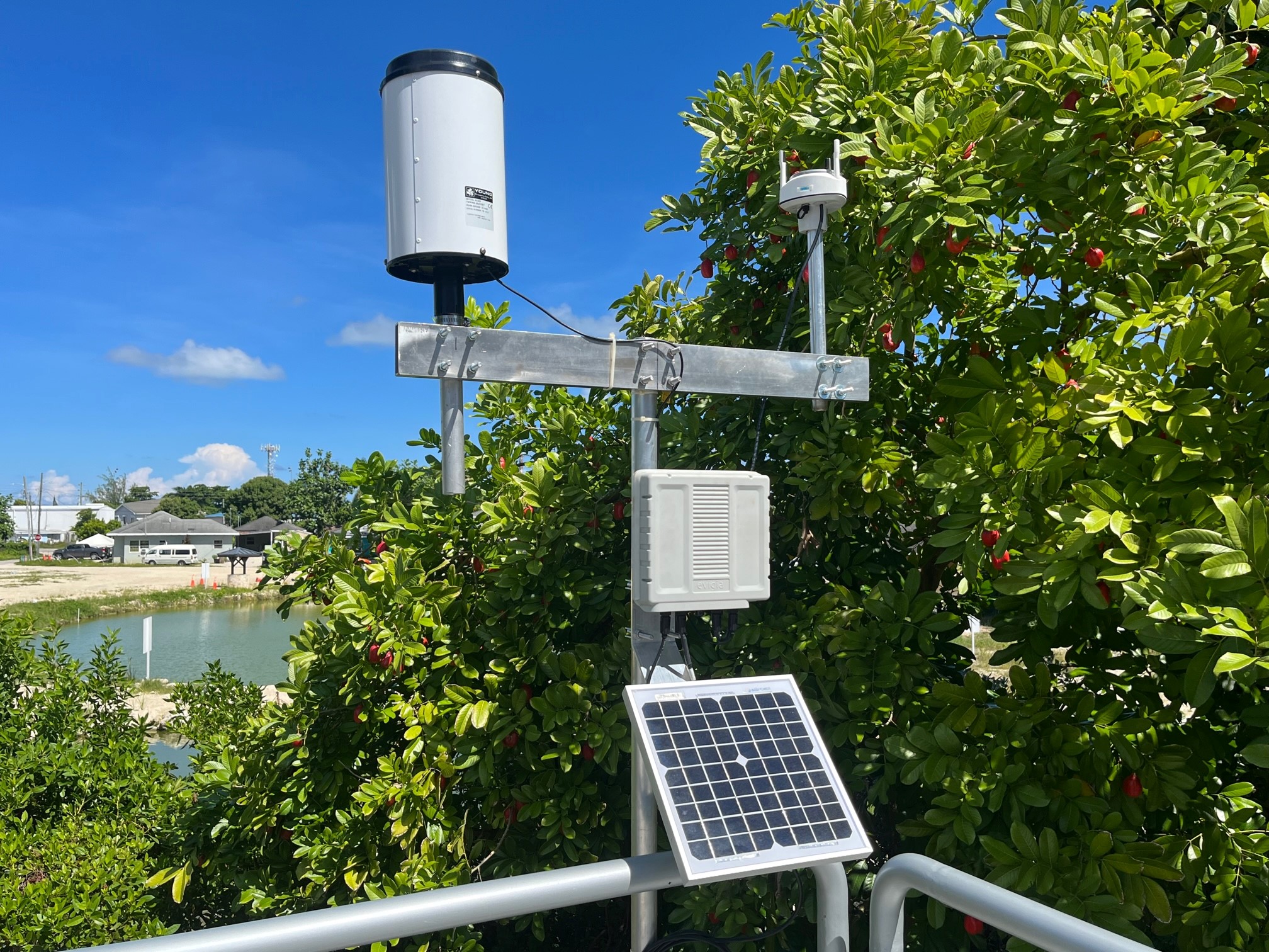
Hazard Management is working with several partners to install sensors that will provide a better understanding of flood risks in the Cayman Islands.
They may even help the department to anticipate and warn of possible flood impacts before they occur, the climate change lead said.
Staff are also working towards developing public flood maps to inform planning and development.
While it may not be possible to retreat from flood-prone areas, the territory can certainly adapt to build in ways that limit or reduce the possible impacts, Boxall said.
And by doing this “the Cayman Islands [will] continue to thrive even in the face of rising sea levels”.
Editor’s note: James Whittaker, president of the Cayman Renewable Energy Association, is not related to Cayman Compass journalist James Whittaker.
Related Videos


Does this mean the government is finally going to fix SMB which is now 2 mile beach