
For the latest information on storm activity in the Cayman Islands, as well as information on how to prepare for hurricane season, visit Storm Centre.
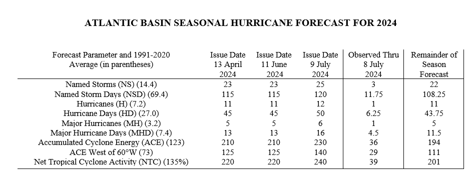
Colorado State University Tropical Meteorology Project has increased its forecast for the Atlantic hurricane season to 25 named storms, 12 hurricanes and six major hurricanes in what is expected to be an ‘extremely active’ season.
CSU’s Tropical Meteorology Project, in its April and June forecasts, had originally called for 23 named storms – accompanied by winds of 39 miles per hour or higher – with 11 expected to become hurricanes and five major hurricanes.
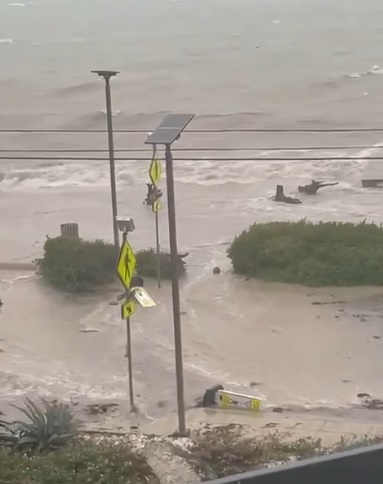
The updated forecast follows the record-breaking passage of Hurricane Beryl, which is now a post-tropical cyclone affecting the United States.
The storm passed just 47 miles southwest of the Cayman Islands last week, causing damage to some coastal properties.
Phil Klotzbach, CSU meteorologist and research scientist, said while he knows that Hurricane Beryl did cause some damage in Cayman, and other parts of the Caribbean were very significantly affected, “I certainly don’t want to scare residents who may have already had very serious impacts this year”.

But, he added, “Unfortunately, the overall atmospheric and oceanic environment remains conducive for a very busy season, with a very warm Atlantic and likely cool neutral ENSO (El Niño-Southern Oscillation) or weak La Nina in the tropical Pacific. This combination of conditions typically is quite favorable for hurricane formation and intensification.”
Klotzbach, in an emailed response to Compass queries, said one important caveat is “even if our forecast is accurate, we cannot say where these storms will form and track”.
He added, “The key is to be prepared and have a plan in place. If storms do threaten, please follow the advice of local emergency managers.”
The combined death toll from the storm had risen to 18 as of Tuesday morning – 10 in the Caribbean and eight in the US.
CSU, in its forecast Tuesday, said it has increased the overall forecast numbers slightly, due in part to Hurricane Beryl.
“Hurricane Beryl, a deep tropical Category 5 hurricane, is also a likely harbinger of a hyperactive season. This forecast is of above-normal confidence. We anticipate a well above-average probability for major hurricane landfalls along the continental United States coastline and in the Caribbean,” it said.
The CSU forecast team currently issues seasonal forecasts in early April and then updates it in early June, July and August.
Some years, Klotzbach said, there is very little change made to the forecast from the first prediction in April to the final one in early August, but other years there are more substantial changes. So far this year, CSU issued the same forecast in June that it did in April and have slightly increased it in July.
“The primary reason why we increased the overall forecast today is due to Hurricane Beryl. While typically early season storm activity does not have much relationship with the rest of the season’s activity, when it occurs in the tropical Atlantic and eastern Caribbean, it tends to portend an extremely busy hurricane season. Normally, that portion of the Atlantic basin is not conducive for storm formation this early in the season, due to dry air, dust and relative cool ocean temperatures,” he said.
The CSU team said it expects 120 named storm days, 12 hurricanes, 50 hurricane days, six major (Category 3, 4 and 5) hurricanes and 16 major hurricane days.
“These numbers include Alberto, Beryl and Chris. The probability of U.S. major hurricane landfall is estimated to be well above its long-period average. We predict Atlantic basin Accumulated Cyclone Energy (ACE) and Net Tropical Cyclone (NTC) activity in 2024 to be ~185% of their 1991–2020 average,” it added.
Colorado State University has increased forecast & calls for extremely active 2024 Atlantic #hurricane season with 25 named storms (including Alberto, #Beryl, Chris), 12 hurricanes & 6 major hurricanes. Very warm Atlantic continues, while #LaNina likely.https://t.co/y3q5SmEuyo pic.twitter.com/IWtHalzYcP
— Philip Klotzbach (@philklotzbach) July 9, 2024
Klotzbach said since CSU is forecasting overall seasonal levels, “Beryl has already generated a large amount of activity, so consequently, the forecast for the rest of the season hasn’t really changed that much”.
Sea surface temperatures averaged across the hurricane Main Development Region of the tropical Atlantic and Caribbean remain near record warm levels, the CSU team said.
“Extremely warm sea surface temperatures provide a much more conducive dynamic and thermodynamic environment for hurricane formation and intensification,” it added.
CSU said it anticipates a cool neutral El Niño-Southern Oscillation or La Niña during the peak of the Atlantic hurricane season, “resulting in reduced levels of tropical Atlantic vertical wind shear”.
As with all hurricane seasons, the CSU has reminded coastal residents that “it only takes one hurricane making landfall to make it an active season. Thorough preparations should be made every season, regardless of predicted activity”.
“Our confidence this year is higher than normal for a July forecast based on the strength and persistence of the current hurricane-favorable large-scale environmental conditions,” it added.
The next CSU forecast is scheduled for 6 Aug.
‘Remain prepared’

Though a lull in hurricane activity is anticipated in the coming weeks in the Atlantic basin, Colorado State University research scientist Levi Silvers says it is key that the community remains prepared with an plan action in place for any storm activity.
The Cayman Islands had a close call with Hurricane Beryl, now a tropical storm, as it passed 47 miles southwest of the islands at its closest point of approach last Thursday. It was a Category 3 storm at that stage.
While the islands escaped serious damage, Caribbean countries such as Jamaica, Grenada and Union Island were not so fortunate and are still dealing with the severe impacts from the storm.
Silvers, speaking with the Cayman Compass on Monday, says the limited impact on the Cayman Islands could be attributed to the size of the storm at the time and the circulation of its bands as it passed by.
However, he said while Cayman escaped serious damage, residents should still keep their hurricane supplies ready and plans in place as the warmer sea temperatures will continue to fuel storms.
“I think [Beryl] really confirmed what the impact of that warm sea surface temperature is and that’s one of the primary things that we were saying is going to drive a super active season is that abnormally warm surface water, and this really confirms that,” Silvers said.
He said weather models and forecast tracks were getting better at prediction.
5am EDT July 4th Key Messages for #Hurricane #Beryl: The major hurricane will pass near the Cayman Islands this morning, & Yucatan Peninsula and Belize tonight where strong winds, dangerous storm surge, damaging waves, & flooding are expected to occur.https://t.co/RX183Ip5Fx pic.twitter.com/csIiFQ2Xek
— National Hurricane Center (@NHC_Atlantic) July 4, 2024
He said CSU’s Tropical Meteorology Project is maintaining its projection of as many as 23 named storms, with winds of 39 mph or higher, for the hurricane season.
Of those named storms, 11 are expected to become hurricanes, with winds of at least 74 mph; and five of those hurricanes are expected to strengthen to Category 3 or higher, becoming major storms with winds of at least 111 mph.
The key record-breaking characteristic of Beryl, he said, is the early formation of such a strong storm ahead of the peak of the Atlantic hurricane season, which is from August to October.
“People just need to be prepared and I think people can do this. I think our culture can adapt, and can know how to prepare for these things. People on the Cayman Islands are probably much better than a lot of other communities dealing with tropical storms. I imagine you will have more tropical storms that directly impact the Cayman Islands this year. I just hope it’s not like Category 4 hurricanes,” Silvers said.
Hotter seas fuel storms
Looking at Hurricane Beryl’s rapid development and sustained intensity, Silvers said, brings a level of accuracy in the projections that have been issued.
“We felt very confident this would be an extremely active season. So it’s interesting to see it off to such an active start and I think that helps us be more confident in the verification of that [projection]. But we’re also grateful that Beryl wasn’t worse,” he said.
Silvers said part of the reason they issue forecasts is to try to help people have a plan and be prepared so that they can relax, “because nobody can sustain being really stressed all the time”.
“If you make a plan, then you just know, ‘I have my plan, I have my supplies right here, this is what I’m going to do. These are the people I’d contact. These are the things that have to happen for me to evacuate or something like that’. Then you can pay attention, but not be stressed, and that’s our hope,” he said.
Silvers added this is the CSU’s recommendation to people even if a quiet season were forecasted.
“A quiet season [will] still have a few storms and those few storms are going to hit somewhere. So people need to be prepared, even in a really quiet season. Once they’re prepared, the hope is that the anxiety levels can actually go down, not go up,” he said.
Beryl’s record-breaking run
Beryl, on Monday, continued to batter Texas as a tropical storm.
The storm has broken a few records on its path through the Caribbean.
This analysis from the National #Hurricane Center nicely shows the long and frequently violent track of #Beryl‘s wind swath as it tracked across the tropical Atlantic, Caribbean and Gulf of Mexico before making its final landfall in Texas a few hours ago. pic.twitter.com/SpVKnJ7x9r
— Philip Klotzbach (@philklotzbach) July 8, 2024
Beryl is now the earliest Atlantic Category 5 hurricane on record, breaking the old record by Hurricane Emily on 17 July 2005. It attained Category 5 status on 2 July.
The storm spent 4.5 days as a major (Category 3+) hurricane and clocked 9.75 named storm days.
Its 65 mph/24-hour intensification rate from 29-30 June was the fastest on record for an Atlantic named storm this early in the calendar year.
The previous earliest 65 mph/24-hour intensification rate was Bertha from 6-7 July 2008, according to statistics shared by CSU meteorologist Philip Klotzbach.
Related Videos


