
For the latest information on storm activity in the Cayman Islands, as well as information on how to prepare for hurricane season, visit Storm Centre.
Beryl intensified to a Category 5 hurricane with maximum winds of 160 miles per hour on Monday night, as the Cayman Islands remain under a Hurricane Alert.
This latest development from Beryl is a record-breaking event, as it has now become the earliest calendar year Atlantic Category 5 hurricane on record.
The prior record was Hurricane Emily on July 17, 2005, Philip Klotzbach – meteorologist at Colorado State University – said in a post on X, formerly Twitter.
The Cayman Islands National Weather Service, in its 10pm update, said it is monitoring Hurricane Beryl, which as of 10pm Monday was located 840 miles east-southeast of Kingston Jamaica and 1155 miles east-southeast of Grand Cayman.
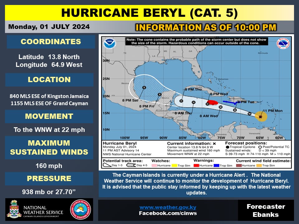
“Residents are encouraged to remain vigilant and stay updated with the latest weather developments,” a government advisory stated.
At 10pm, Beryl was moving toward the west-northwest near 22 miles per hour and is forecast to continue moving rapidly west-northwestward during the next couple of days, the US National Hurricane Center said in its latest advisory.
“On the forecast track, the center of Beryl will move quickly across the southeastern and central Caribbean Sea tonight through Tuesday and is forecast to pass near Jamaica on
Wednesday,” it said.
The NHC said that recent data from the US National Oceanic Atmospheric Administration Hurricane Hunters indicates that the maximum sustained winds have increased to near 160 miles per hour with higher gusts and it is now a potentially catastrophic Category 5 hurricane on the Saffir-Simpson Hurricane Wind Scale.
“Fluctuations in strength are likely during the next day or so, but Beryl is expected to still be near major hurricane intensity as its moves into the central Caribbean and passes near Jamaica on Wednesday. Some more weakening is expected thereafter, though Beryl is forecast to remain a hurricane in the northwestern Caribbean,” it said.
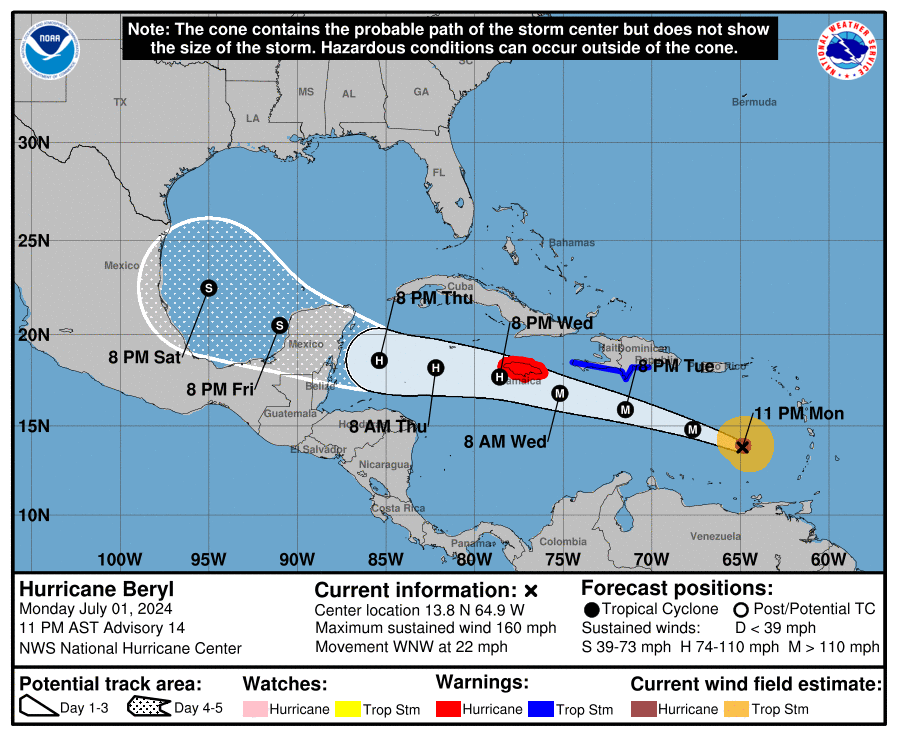
Hurricane-force winds extend outward up to 40 miles from the center and tropical storm-force winds extend outward up to 125 miles.
“Hurricane conditions are expected to reach the coast on Jamaica within the warning area on Wednesday. Winds are expected to first reach tropical storm strength early on Wednesday, making outside preparations difficult or dangerous,” the NHC advisory said.
Tropical storm conditions are expected in the warning area along the south coast of Hispaniola by late Tuesday.
Storm surge could raise water levels by as much as 3 to 5 feet above normal tide levels in areas of onshore winds along the immediate coast of Jamaica, the NHC said.
Related Videos


