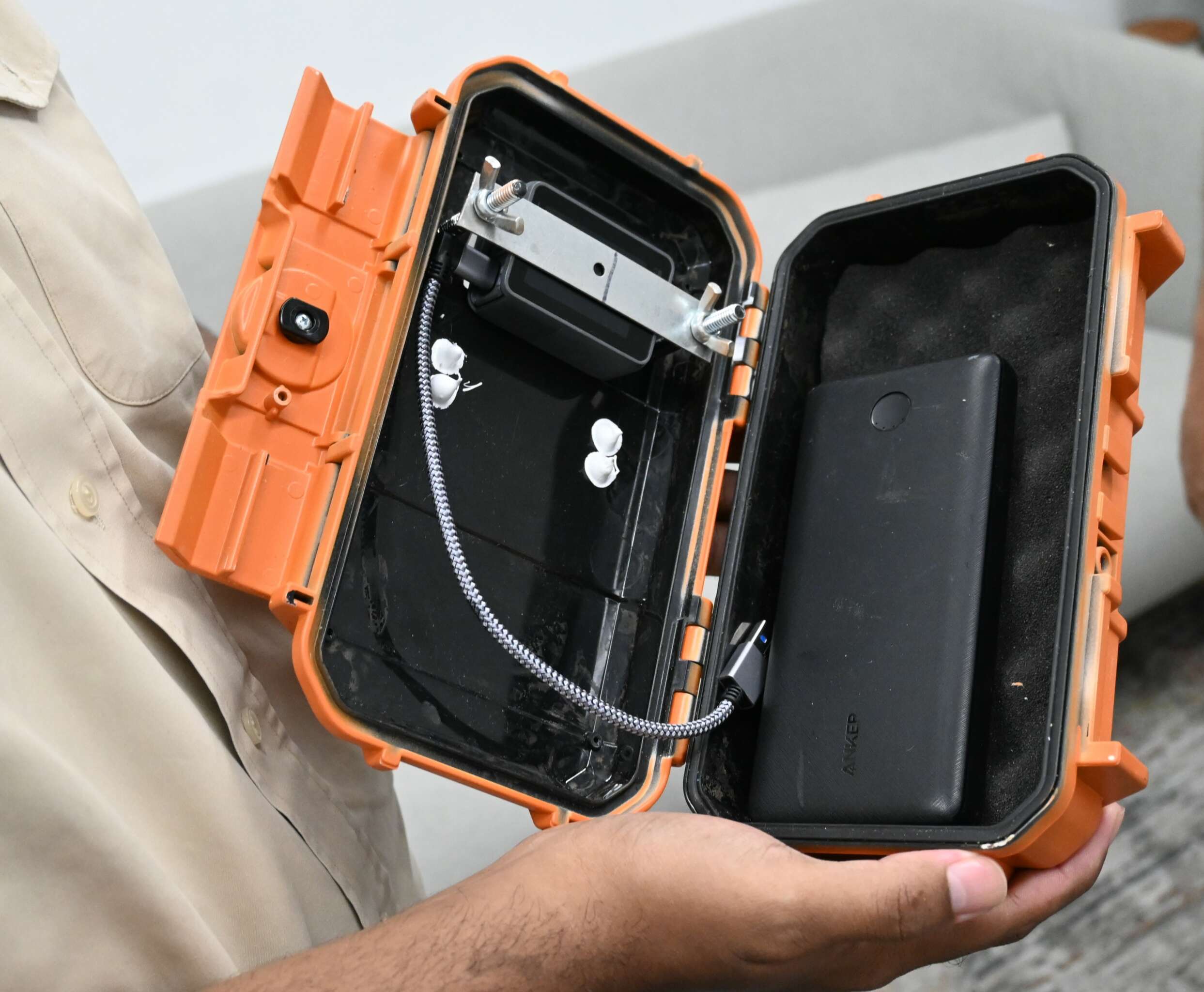
High-powered GoPro cameras encased in military-grade capsules will be used as part of a new pilot project to track storm surges and severe weather activity in the Cayman Islands this hurricane season.
The project, which was launched this week, is a partnership between US-based storm chaser Mark Sudduth, founder of the Hurricane Track website, and local weather enthusiast Adam McDoom.
Sudduth and McDoom have been in communication for years, working together on tracking storms through the Caribbean.
Following Hurricane Beryl’s historic run earlier this month, they decided to collaborate on this new data collection project.
“It’s a good way to capture impacts. Then we can use this video evidence data to further educate people, to help the National Hurricane Center in Miami to see what storm surge in particular does in Grand Cayman, and we can do it safely because these boxes are military-spec cases,” Sudduth told the Cayman Compass.
He added, “They’re sealed and they can take a Category 5 hurricane. They’ve been through them before.’
Sudduth, whose operation is based out of the Carolinas and who often provides storm coverage on Fox Weather and the Weather Channel, was on island for a two-day stopover to deliver two sealed cameras.
They will be placed strategically on Grand Cayman’s coastline when there is any severe weather activity.
That’s where McDoom comes in. He is tasked with deploying the cameras ahead of any extreme weather.
He says gathering this footage will help get clear imagery of storm impacts in the Caribbean.
“Unfortunately, our area, the northwestern Caribbean, tends to be the area where we do tend to see a lot of rapid intensification,” McDoom said. “A lot of strong hurricanes tend to move through. This project would allow us to document that and get a clear visual of what happens with hurricanes as they approach our area.”
Each storm case contains a GoPro camera and a battery to power it for about 20 hours.
The cameras will only be recording data in this initial phase, but McDoom said, in the future they hope to be able to livestream the footage.
At this time, he said, the network capability is not available to support livestreaming.
Valuable footage
Sudduth said, through the camera footage, he expects to collect some interesting data.
“We can see how high the water was, the wave action … how it flows in and flows out, the debris patterns. Then there may be things that we weren’t expecting. Maybe there’s a water spout that comes onshore as a tornado … sometimes there is a discovery that you get simply because video becomes data,” he said.
The cameras inside their watertight casing, he said, can also record people going by the shore to take photos when they should have evacuated, to show the danger of that practice.
Sudduth said he has partnered with individuals in the US Virgin Islands, St. John and St. Thomas to deploy similar capsules when any significant weather events occur in their area.
The duo has discussed their project with teams from Hazard Management Cayman Islands and the National Weather Service, with whom they will share critical footage to determine patterns and impacts.
Both Sudduth and McDoom said if there had been similar facilities available when Hurricane Ivan hit the islands in 2004, there would have been clear footage of the storm’s impacts and the conditions that came with it.
“This will give us a localised picture of what actually happens here in Grand Cayman and helps us to prepare for that in a much better way in the future,” McDoom said.
Sudduth said the cameras will be deployed safely, so McDoom will not be at risk.
McDoom said the locations for deployment will be determined on a case-by-case basis as the locations will change based on the projected images.
Looking ahead
Colorado State University’s Tropical Meteorology Project increased its forecast for the Atlantic hurricane season last week to 25 named storms, 12 hurricanes and six major hurricanes in what is expected to be an ‘extremely active’ season.
It said, in its forecast, that Hurricane Beryl was “a likely harbinger of a hyperactive season”.
The National Weather Service confirmed that Beryl’s closest point of approach to the island was 47 miles south of Grand Cayman.
Sudduth said looking ahead for the season, based on the early trends and modeling affirmed by Beryl’s passage, the western Caribbean will be quite active and it will be a “very impactful season”.
“It looks like we’re going to have both. The steering of Beryl, going all the way from Africa into Texas, and then the very deadly trip through the Caribbean in the middle, suggests too that we’re going to have a lot more westward-moving activity this year,” he said.
Sudduth said some systems will curve out harmlessly into the Atlantic, but “most of the climate models show westward tracks, very warm water temperatures and a very favourable atmosphere”.
While he said he does not want to alarm anyone, Sudduth urged the community to be prepared for the active season ahead.
He suggested that once the season enters its peak in mid to late August, and probably through October, “we could be looking at repeat hits in places, unfortunately, like the Cayman [Islands], like St. Vincent and the Grenadines. We are just getting started.”
Related Videos


