
A draft environmental statement relating to the East-West Arterial has revealed that the cost of building and maintaining the eight-mile road extension to the eastern districts will be more than US$1 billion over the next 50 years.
According to the environmental statement – part of the legally mandated environmental impact assessment process for the extension – the first 10-year phase of the road, which is expected to begin construction next year, is expected to cost almost CI$234 million (US$278.4 million).
The report notes that the average cost of the 8-mile-long road extension from Woodland Drive to Frank Sound Road over the next half century will be CI$18 million a year – without inflation being taken into account.
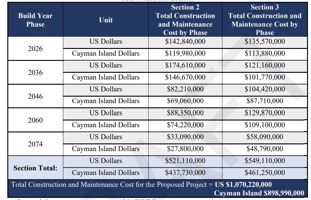
The estimated cost of construction and maintenance expenses between 2026 and 2074 is CI$898.99 million (US$1.07 billion), with an additional CI$17.09 million for right-of-way acquisitions.
The report stated that each parcel of affected land along the extension was individually analysed, “with some requiring partial acquisitions and others necessitating the acquisition of most or all the property”.
It continued, “In addition to land area, the presence of homes, commercial buildings, and other structures such as fences, walls, gates, and landscaping were factored into the property impact assessment. The effort required to demolish existing structures was also considered in the cost estimation. Further property considerations included the presence of wetlands, parrot habitat, and any potential impact to [National Trust] lands.”
The road plan – opposed by conservationists amid concerns over its encroachment into the Central Mangrove Wetland and flooding worries, but welcomed by many daily commuters from the eastern districts – is now subject to a second round of public consultations, after the draft environment statement was released Monday, 13 Jan.
As well as a detailed 694-page document, a draft non-technical 65-page summary has also been released.
The report notes that based on analysis results, parcels of land south of the extended route, which will have a lower density of protected land and will have better transportation access once the road opens, will be attractive areas for development. Land to the north is less developed and includes protected swathes of land owned by the National Trust such as the Mastic Reserve.
According to the environmental statement, drawn up by the National Roads Authority, the road extension “will improve traffic conditions between the eastern and western districts of Grand Cayman, will strengthen resiliency by adding a second travel route between districts, and will offer easier and more timely access”.
It is anticipated that construction of an initial two-lane roadway along the southern part of the extended East-West Arterial will begin next year. In subsequent years, the report points out that the road may be widened with the addition of two more lanes and a utility corridor.
Sea level rise not included in EIA
The report notes that sea level rise due to climate change has not been included within the modelling conducted by consultants Baird as part of the environmental impact assessment for the road extension. However, it stated that it is recommended this be considered during the detailed design phase of the corridor, outside of the EIA.
It pointed out that along the planned road extension, it is estimated that sea levels could rise up to 1.64 feet over the life of the road, noting that the lowest areas of the roadway surface are currently designed to remain dry at the edge of the travel lanes during a major storm.
“While the road may still be passable at higher points during such events when accounting for sea level rise, the increasing frequency and severity of flooding could disrupt traffic flow and escalate maintenance costs. To address these issues, it is imperative to incorporate sea level rise considerations into the hydrologic and hydraulic analysis during the detailed design phase of the project,” the report noted.
Travel times
The National Roads Authority report predicts that, with the new road in place, the average travel time from the eastern districts to George Town will fall over the next 50 years.
Many residents in the eastern districts, at public meetings and consultations, have argued strongly for the extension, saying it will help ease traffic congestion at peak commuting times of the day.
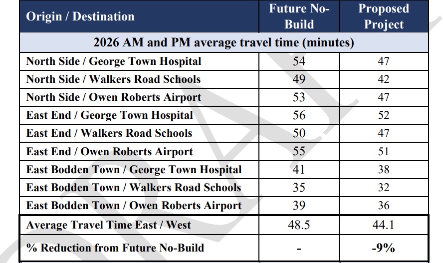
The environmental statement notes that the extension would knock seven minutes off a journey from North Side to George Town Hospital (from 54 minutes to 47) or cut three minutes off a trip from East Bodden Town to the hospital (from 41 to 38).
It also calculated what travel times would be like in 50 years, taking an estimated doubling of the population to 135,000 into account. The report noted that, by 2074, it would take 83 minutes to travel from North Side to George Town Hospital if the road extension does not go ahead. If the road is in place, it estimates that travel time will be 61 minutes.
It noted that tourists would also be able to travel quicker to popular sites like Rum Point, Queen Elizabeth II Botanic Park or the Mastic Trail once the road is completed, boosting tourism for those areas.
The report pointed out that, according to the 2021 census, at least 7,000 people – more than 10% of the population at the time – work in George Town and live in one of the three eastern districts.
“Improved access to and from the western side of the island is essential for employment, as well as other services on Grand Cayman,” it noted.
Emergency access
The issue of emergency access was also addressed in the report – and was one of the topics that was also raised in the public meetings.
Noting that Bodden Town Road is currently the only road that connects the area of Grand Cayman east of Bodden Town with the western districts, an incident or disaster on that section could cause major access issues.
“A lack of accessibility due to a road closure can have severe effects on socio-economic quality of life, including the ability to reach emergency services, work, or school,” the report noted.
This would be avoided if the new road is built, the report states.
Design plans
The report highlighted what it described as “sustainable, long-term multimodal transportation solutions for the island” that will be included in the design of the East-West Arterial extension, meaning it takes into account modes of transport other than motorised vehicles, such as walking, biking, or riding a scooter.
It says this includes multiple traffic lanes, separate transit lanes for public transportation, a micromobility path for scooters and bicycles; a sidewalk; a solar array; utility corridors for future infrastructure; pipes and culverts to maintain water flow through adjacent habitats; and stormwater management basins to protect ecosystems.
Bridges are also expected to be included in the plan to help with maintaining natural water flow and possibly reduce flood risk to nearby properties.
Public meetings this month
The draft environmental statement is the forerunner for a final environmental report for the extension.
It was developed by the National Roads Authority, along with the Environmental Assessment Board which includes representatives from the Department of Environment, Department of Planning, Water Authority Cayman and the Public Works Department.
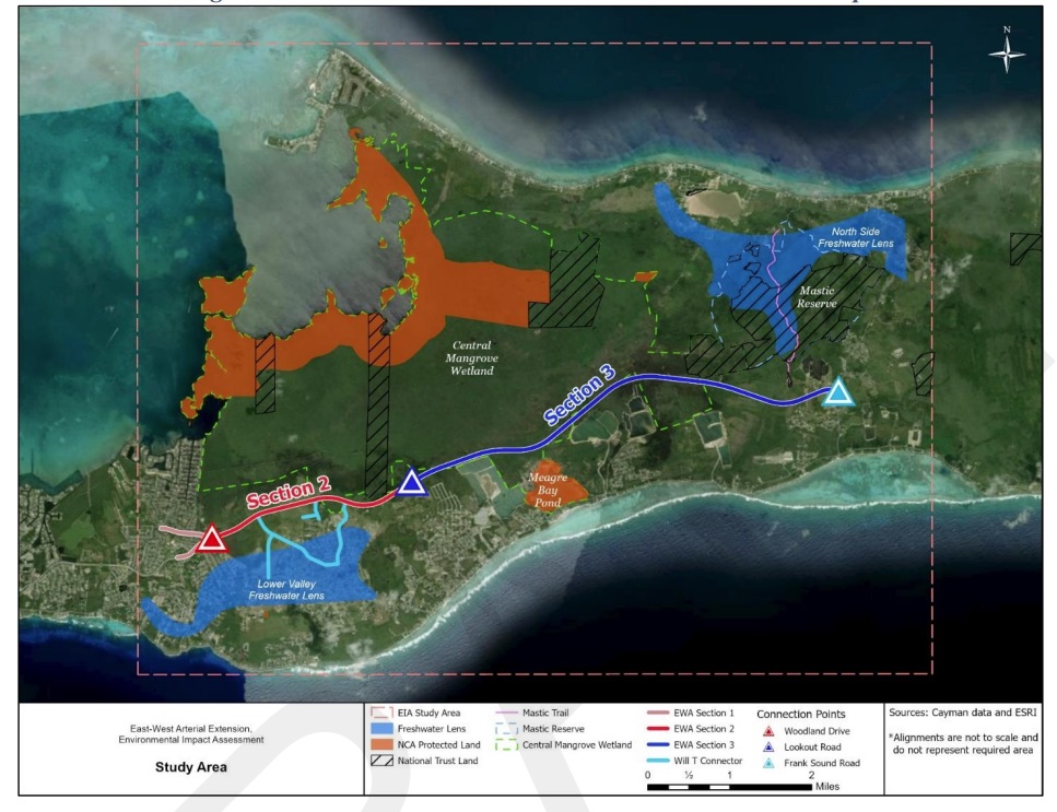
The new roadway – which will be built in two separate phases – will start at the end of section 1 of the East-West Arterial, from Hirst Road to Woodland Drive, which is currently under construction, and will travel east to a new intersection with Frank Sound Road. It will also include a series of roadways described as the Will T Connector.
The National Roads Authority is inviting the public’s feedback on the draft environmental statement before the document is finalised.
It will hold two public meetings this month to discuss the draft document.
The first will be held at the Craddock Ebanks Civic Centre in North Side, from 6-9pm on Tuesday, 21 Jan.
The second will be at the Church of God Chapel’s hurricane shelter on Shamrock Road, Bodden Town, from 6-9pm on Thursday, 23 Jan.
The draft environmental statement can be viewed online at conservation.ky/eia-reports/ and https://youreia.caymanroads.com.
Printed copies are available for review at the NRA office, 370 North Sound Road, George Town or at the DoE office, 580 North Sound Road, George Town.
Comments on the document may be submitted as follows:
- In writing during the public meetings – comments sheets will be provided;
- Electronically via email to [email protected];
- Mailed to Department of Environment, P.O. Box 10202, Grand Cayman KY1-1002; or
- Hand delivered, in writing, to Department of Environment, Environmental Centre, 580 North Sound Road, George Town, Grand Cayman.
The public consultation will close on 3 Feb.
Related Videos


The absolute biggest savings in travel time would come from an overpass at the AL Thompson and Hurley’s roundabouts.
By the time you get to this planned road the traffic has already reduced.
Cut traffic time? Is the minutes worth $1 billion? People you will get bottle neck at the hot spot areas on the island. We and our great grandchildren will be paying for this road. Can we afford milk prices $25 gallon, $10 a gallon for fuel, $12 for a loaf of bread? And all at the cost of the environment. People this road isn’t for you or me, this is primarily to open lands for development and we the “people” will be paying for this and the risk of flooding existing homes in the area. No thanks, keep your road!
Let’s get it done! Costs are not going down. And the cost re: frustrations, gridlock, time wasted stuck in traffic, unsafe roadways for main road with secondary roads and driveways every couple hundred feet, all make for negative impacts.
The best time to build a road is 20 years ago. The second best time is RIGHT NOW
While it may be true that the best time to plan infrastructure would have been before we developed, we now need to ensure that development doesn’t come at the expense of our environment, safety, and long-term sustainability. It’s important we make informed decisions that consider both immediate benefits and future impacts, and the socioeconomic needs of the people based on quantitative data and economics. #SustainableGrowth 🌱