Most of the members of the Cayman Islands Tourism Association who were polled last week do not support the development of a seaport in East End.
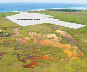
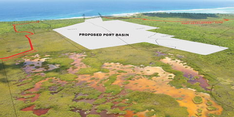
CITA is just the latest group to rally against plans by private developer Joseph Imparato to develop a seaport west of East End. The site is on privately owned land in the High Rock area, east of Half Moon Bay.
The mounting discontent over the project comes on the heels of a report from Government’s Environmental Advisory Board concerning a draft environmental impact assessment study done for the proposed seaport.
The board found that the impact study had not employed “internationally recognised methodology for assessing the impacts of the proposed works… and therefore make it impossible for the reader to decipher the impact analysis as presented, which should be objective wherever possible.”
The issues of concern to the Tourism Industry, according to CITA, include:
“The proposed development has not considered nor aligned with the recommendations and guidelines established in the National Tourism Management Policy 2009-2013 for which the tourism industry was consulted extensively.
“If all Port Authority operations were relocated to East End, the additional trucking fees would significantly increase the cost of doing business, and therefore drive up the cost of living as well as force up the prices that will have to be charged to visitors and residents. With the Cayman Islands already struggling by being perceived as an expensive destination, an additional increase would have a negative impact on this factor.
“The project would destroy at least two popular dive sites and damage at least five additional dive sites that are frequented by tourism visitors to East End and Grand Cayman. The quality and variety of dive sites is one of the main attractors for this area of the Island.
“The developer has acknowledged that the dredging and excavation of the proposed port basin project will negatively impact the East End Water Lens.
“The project will stimulate negative international media coverage related to the environmental impacts caused by the project.”
CITA said it supports proposed new projects to benefit the Tourism Industry, including the proposed medical tourism hospital, cruise berthing facilities in George Town, Owen Roberts Airport re-development and the re-development of derelict hotel properties such as the former Courtyard Marriott.
The Environmental Advisory Board, which was chaired by Director of the Department of Environment Gina Ebanks-Petrie and made up of members of the Planning Department, National Roads Authority and the Water Authority, stated in its report that its concerns “require addressing prior to finalising its comprehensive review of the environmental impacts”.
Draft legislation regarding the development that was supposed to be attached to the draft environmental impact report was missing and the Department of Environment had not been given a copy.
The draft environmental impact report into the proposed seaport, which will include a commercial cargo port, cruise ship home port, luxury mega yacht marina, hydrocarbon storage facility and transhipment of cargo containers was released in May.
Because the 516-acre project lies within a 1,500-acre Port Development Zone, the board said it wished to highlight concerns about potential wider cumulative impacts of the development. These included the water lens, terrestrial resources and existing and planned road corridors and associated infrastructures.
The environmental impact assessment report, prepared by South Florida-based Hesperides Group, therefore would need to be extended to assess the impacts of the development based on proposals for the zone, which remained unknown to the board.
Wave energy
The board’s report said no modelling of normal and worst case wave energy as a result of the project, including storm surge evaluation, had been undertaken as stipulated in the terms of reference. It said the omission of modelling scenarios was a “fundamental flaw, particularly given the highly contentious nature of this issue in the public’s perception”.
The board recommended that, since the impact the project would have on wave energy would likely be a key decision point, a third party should carry out an assessment of the modelling done, again as per the agreed terms of reference.
Further, in the terms of reference, there was no analysis of design alternatives to the proposed project and the “no action alternative” did not comprehensively describe conditions which would remain the same if the proposed facilities were not constructed. This was “an important part of establishing a baseline position against which to assess the potential impacts of the Seaport”.
There was also no presentation of a preferred alternative and associated design alternatives nor an explanation why the location and design for the proposed project is preferred over the other alternatives, the report said.
The report also said there was an insufficient description of the proposed project. It called for a detailed excavation plan which outlined quality and volume of sediment and details of all excavation depths, details of on-site aggregate processing and detailed turbidity control measures. It said that as the Seaport was presented as a part of a wider development zone, the assessment should reflect this in areas such as how hydrocarbon storage would relate to adjoining uses.
Incomplete aspects
Other incomplete aspects according to the advisory board included socio-economic and cultural resource evaluations, visual impact analyses, geology and an absence of qualitative or quantitative ambient noise.
The Draft Environmental Impact Report must also determine the potential impacts of the project on wave energy, turbidity during construction and operation, water quality, ground water, marine transportation, hazard vulnerability, noise impact, hazardous materials, road traffic and the economic impact including agricultural, infrastructural and existing commercial quarries.
Mitigation and management measures could not be made objectively as there was an ‘absence of a transparent and objective assessment of the significance of each of the impacts.’ Additionally, the report did not detail where responsibility lay for the implementation or cost of such measures. A monitoring plan as a standalone document for each stage of the document process should be addressed.
Following receipt of the additional information, read the environmental board’s response, it would continue its review process.
Opposition
Arden McLean, the Member of the Legislative Assembly for East End who has been vocally opposed to the East End port proposal, told legislators Thursday that government’s Environmental Advisory Board’s report on the environmental impact study showed the study was “not worth the paper it was written on”.
He said the report showed the methodology used for the environmental impact study was not the “proper one”.
“It is not a thorough study,” said Mr. McLean.
He told legislators that he was almost ready to bring a petition opposing the seaport to the Legislative Assembly.
He also recapped what he had said during a public meeting attended by the public and Mr. Imparato at the civic centre in East End on 9 June. “I told Mr. Imparato that his project is not welcome in the district of East End,” Mr. McLean said.
Protest signs
Mr. McLean told lawmakers during a debate on the budget in the Legislative Assembly Thursday that he had been contacted by the Director of Planning Haroon Pandohie to say that signs saying “No to Mega Quarry” erected to protest the port development did not have planning permission.
“I said to him… I would like to see you and the government send out a task force to move all of the illegal signs in the country that were put up before these… It’ll be two years before you reach me,” said Mr. McLean.
“Do not exercise might over right,” the East End MLA said. He said most of the signs were on government land, but that he would remove one on land owned by Mr. Imparato.
Related Videos


Ezzard Miller and company opposing progress, fully prepared to take opportunity from Caymanians for political gain and self importance. Yawn… What else is new?
Alfonso you are so wrong. Tells us where your head is.
Need servicing!
Well then Dubai. Since you threw down the gauntlet half arsed.
Explain to us all why Alfonso is so wrong about Mr Miller.
Explain what Mr. Miller has done to promote progress. (ie, something that has actually been done by Mr Miller, not just proposed).