
For the latest information on storm activity in the Cayman Islands, as well as information on how to prepare for hurricane season, visit Storm Centre.
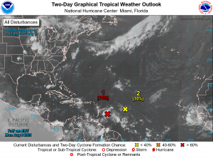
Forecasters are projecting a low pressure system located about 150 miles east of Barbados to develop into a tropical depression later today.
This system, one of two churning in the Atlantic basin, is the most active in the Caribbean since Tropical Storm Elsa hit in early July.
The US National Hurricane Center, in its Monday morning advisory, said showers and thunderstorms have become more concentrated today in association with the low pressure system.
“Environmental conditions are expected to be conducive for additional development, and a tropical depression is likely to form later today or tonight while the low moves west-northwestward at 10 to 15 mile per hour,” the NHC said.
Hazard Management Cayman Islands, on its official Facebook page, said the disturbance is no threat to the Cayman Islands at this time.
“It is currently expected to pass north of our area, however there is a degree of uncertainty in the long range forecast track and residents should monitor this region of low pressure as it begins its approach into the Caribbean Sea,” the HMCI post said.
The NHC said the disturbance is forecast to reach portions of the Lesser Antilles Monday, then move near the US Virgin Islands and Puerto Rico on Tuesday, and be near Hispaniola around the middle of this week.
“Tropical storm watches or warnings could be required today with shorter-than-normal lead times for portions of the Lesser Antilles, the Virgin Islands, and Puerto Rico. In addition, heavy rains and flooding are likely for the Leeward Islands, Virgin Islands, and Puerto Rico. Interests in those areas should monitor the progress of this system,” the NHC advised.
The system has a high formation chance of 70% both through 48 hours and the next five days.
Should the weather system develop into a storm, the next name in line for the Atlantic hurricane season is Fred.
Meanwhile, the development of the second weather system, the NHC said, is becoming less likely during the next few days while it moves toward the west or west-southwest at around 10 mile per hour several hundred miles east of the Lesser Antilles.
The NHC said disorganised showers and thunderstorms have changed little in association with an elongated low pressure area.
This system has a formation chance 10% through 48 hours and 20% through the next five days.
Related Videos


Why is our National Weather Service radar down for maintenance in the middle of hurricane season? That would make a GREAT story. We all deserve to hear why.
Thanks very much for your question. You can read more about this story here: https://www.caymancompass.com/2021/08/10/suspected-lightning-strike-knocks-out-weather-radar-generator/