
For the latest information on storm activity in the Cayman Islands, as well as information on how to prepare for hurricane season, visit Storm Centre.
Update: 1am The latest forecast for Tropical Storm Grace from the National Hurricane Center remains unchanged since the 10pm CT update.
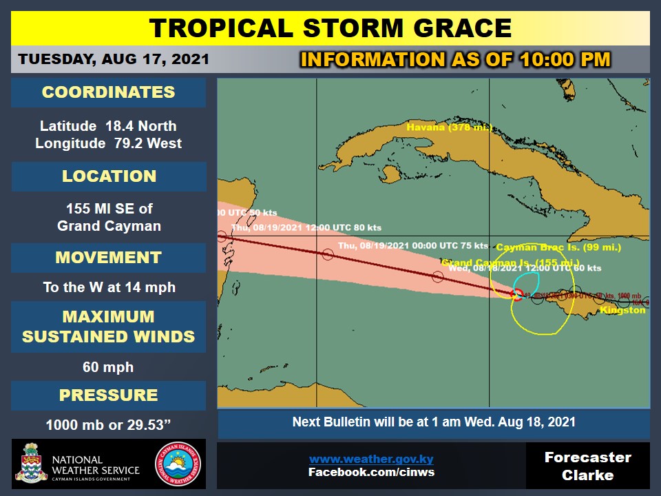
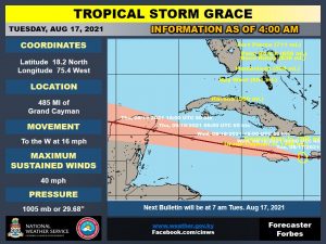
Grace still has sustained winds of 60mph and is moving west at 14mph, with a track that will take it over or near Grand Cayman early Wednesday morning.
At 1am CT, Grace was located approximated 85 miles east-southeast of Grand Cayman and approximately 70 miles south of Cayman Brac, according to the NHC advisory.
The tropical storm is forecast to become a hurricane later on Wednesday.
Update: 10pm Tropical Storm Grace is forecast to move near or over the Cayman Islands early Wednesday, according to the latest advisory from the National Hurricane Center.
The NHC added that tropical-storm-force winds extend outward up to 115 miles, primarily to the east of the centre of the storm.
As of 10pm, the Cayman Islands National Weather Service said that Tropical Storm Grace was about 99 miles south-southeast of Cayman Brac and 155 miles southeast of Grand Cayman with maximum sustained winds of 60mph. Grace is moving towards the west at 14 mph.
The forecast remains the same as it was in earlier advisories, with torrential rain and intermittent thunderstorms overnight as Tropical Storm Grace passes south of the island, the NWS said, with a flood warning in effect.
The estimated wave heights have increased for Wednesday to 9 to 11 feet, especially along the east and south coast of Grand Cayman, decreasing to 5 to 7 feet on Thursday.
A marine warning is in effect for the Cayman Islands, the NWS said, adding that all craft should seek and remain in safe harbour.
A general westward to west-northwestward motion for the storm is expected for the next several days, the NHC said.
Grace is forecast to strengthen into a hurricane on Wednesday, with some additional strengthening possible prior to the centre reaching the Yucatan Peninsula.

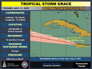
Update: 8pm Tropical Storm Grace is now 143 miles southeast of Cayman Brac and 223 miles east-southeast of Grand Cayman, with the National Weather Service saying storm surges of 1 to 3 feet are possible for portions of the Cayman Islands.
The NWS, in its the 7pm advisory, said overcast skies with torrential rain and intermittent thunderstorms is expected overnight as Tropical Storm Grace passes south of Grand Cayman.
Showers will be locally heavy at times leading to flooding of low-lying areas.
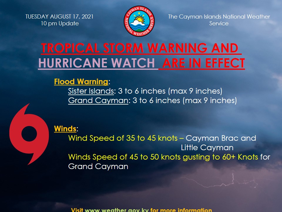
A flood warning is in effect for the Cayman Islands as the NWS estimates 3 to 6 inches up to a maximum of 9 inches of rainfall on Wednesday and 3 to 6 inches of rainfall on Thursday.
Estimated wind direction and speeds Tuesday night, the NWS said, will be east to northeast at 25 to 30 knots with higher gusts on Grand Cayman, and southeast at 35 to 40 knots with higher gusts on the Sister Islands.
The wind will be southeast Wednesday morning increasing to speeds of 40 to 45 knots, gusting to 60+ knots on Grand Cayman and southeast at 30 to 35 knots on the Sister Islands.
By Wednesday afternoon, the winds will drop to 25 to 30 knots southeast on Grand Cayman and 15 to 20 knots on the Sister Islands.
Wave heights are expected
to be 8 to 10 feet Wednesday and 5 to 7 feet Thursday.
The National Hurricane Center in Miami has said reports from the National Oceanic and Atmospheric Administration and Air Force Reserve Hurricane Hunter aircraft indicate that the maximum sustained winds have increased to near 60 mph with higher gusts.
“Grace is forecast to strengthen into a hurricane on Wednesday, with some additional
strengthening possible prior to the center reaching the Yucatan Peninsula. Tropical-storm-force winds extend outward up to 80 miles from the center. A sustained wind of 40 miles per hour and a gust to 52 miles per hour was recently reported at Kingston, Jamaica,” the NHC said.
Update: 4:30pm The Cayman Islands has been placed under a hurricane watch as the islands prepare for the approach of Tropical Storm Grace, Hazard Management Cayman Islands has said.
HMCI, in a post Tuesday afternoon on its official Facebook page, said, “Due to the very close proximity of the forecast approach of the hurricane force wind field for Tropical Storm Grace, a decision has been taken to issue a Hurricane Watch for the Cayman Islands.”
Tropical storm conditions are expected within the next 12 hours.
“Given the forecasted intensity of Tropical Storm Grace, strengthening to a Hurricane is likely to occur as the system moves west of the Cayman Islands,” the National Weather Service has said in its latest advisory.
Grace is forecast to move near the Cayman Islands 3 am on Wednesday.
A hurricane watch, according to the US-based National Hurricane Center, means hurricane conditions are expected somewhere within the warning area.
“A warning is typically issued 36 hours before the anticipated first occurrence of tropical-storm-force winds, conditions that make outside preparations difficult or dangerous. Preparations to protect life and property should be rushed to completion,” the NHC said.
Hazard Management said that tropical-storm-force winds are expected but “residents should be aware that sustained winds of hurricane strength are now possible”.
In a press release announcing the addition of the hurricane watch for Cayman, National Weather Service Director General John Tibbetts said the government decided to take the step out of an abundance of caution as Tropical Storm Grace is expected to become a Category 1 hurricane as it moves out of the Cayman Islands area.

“The combination of a hurricane watch with a tropical storm warning means that in addition to experiencing tropical storm winds within the next 24 hours, it is possible, but not likely, that we will also experience hurricane force winds,” Tibbetts said.
He added that “even a tropical storm is dangerous and has the potential to cause loss of life. As a result it is important for us all to follow public safety messaging, avoid coastlines, refrain from non-essential journeys and stay informed on everything that is happening, until the all-clear can be given.”
The last projection put Grace passing 13 miles southwest of Grand Cayman and 57 miles south of Cayman Brac.
Grace is moving toward the west near 15 miles per hour and is currently 225 miles east-southeast of Grand Cayman. Maximum sustained winds are 50 mph with higher gusts.
“Tropical-storm-force winds extend outward up to 80 miles from the center. The official reporting station in Kingston, Jamaica, has reported sustained winds of 47 miles per hour and a gust to 54 miles per hour within the past few hours,” the NHC said.
“A general westward to west-northwestward motion is expected for the next several days. On the forecast track, the center of Grace will continue to move near the northwestern coast of Jamaica for the next few hours. Grace is forecast to move near or over the Cayman Islands late tonight and early Wednesday, and then approach the Yucatan peninsula of Mexico late Wednesday or early Thursday,” the NHC said.
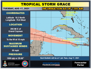
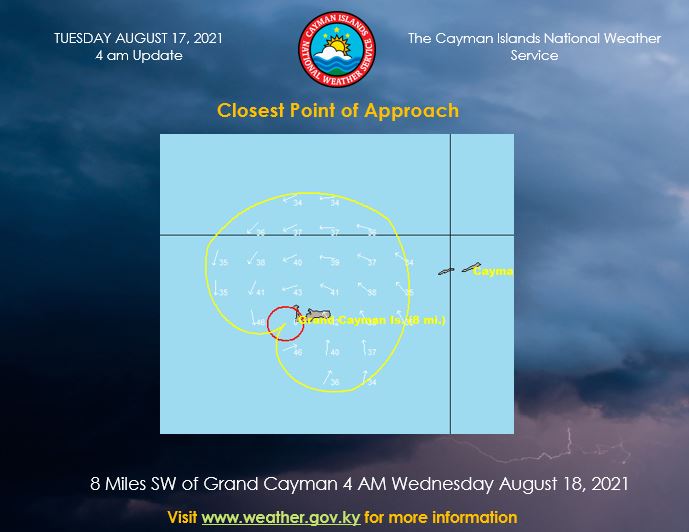
Update: 18 Aug. 11am – Tropical Storm Grace has moved slightly south, taking it a little further away from Grand Cayman, and is now being projected to pass 13 miles southwest of the island.
It was previously projected to pass eight miles southwest, according to early morning reports.
The National Weather Service, in its latest notification Tuesday morning, said tropical storm conditions are expected within the next 24 hours as Grace is forecast to pass 57 miles south of Cayman Brac at 10pm Tuesday.
As for Grand Cayman, it will be 13 miles southwest around 4am Wednesday.
The system is currently 295 miles east southeast of Grand Cayman with maximum sustained winds of 50 miles per hour. Tropical-storm-force winds extend outward up to 70 miles from the centre.
A general westward to west-northwestward motion is expected for the next several days from the storm, the NWS said.
“On the forecast track, the center of Grace will move near the northern coast of Jamaica [Tuesday] afternoon. Grace is forecast to move near the Cayman Islands [Tuesday night], just southwest [of] Grand Cayman 4 am on Wednesday, and then approach the Yucatan peninsula of Mexico late Wednesday or early Thursday,” the NWS said.
Grace is projected to become a hurricane after it passes Grand Cayman on Wednesday, the Miami-based National Hurricane Center said.
Some additional strengthening is possible prior to the centre reaching the Yucatan Peninsula, it added.
Original story: Tropical Depression Grace has been upgraded to storm status and has shifted further south. It is now expected to pass eight miles south of Grand Cayman, based on the latest forecast track from the National Weather Service.
Tropical storm conditions are expected within the next 24 hours, as all three islands remain under a storm warning. Tropical storm force winds are predicted from Tuesday night with wind speeds of 35 to 47 knots.
Grace continued to reorganise and strengthen overnight, according to the latest National Hurricane Center advisory.
It has increased in speed and is now moving at 16 miles per hour with maximum sustained winds of 45 miles per hour.
Tropical-storm-force winds extend outward up to 45 miles from the centre, the NHC said Tuesday morning.
National Weather Service forecaster Gilbert Miller, in a weather update to the Cayman Compass at 5:30am, said Grace was 398 miles to the east of Grand Cayman and 306 miles to the east of Cayman Brac on its current path.
“The closest point of approach for Grand Cayman would be eight miles to the south. For Cayman Brac, it would be 52 miles to the south of Little Cayman [starting] at 10pm on Tuesday and for Grand Cayman, 4am Wednesday August 18,” he said.
The onset of tropical storm force winds for Cayman Brac will be Tuesday night at 8pm and midnight for Grand Cayman.
“The forecast track, the center of Grace will move near the northern coast of Jamaica [Tuesday afternoon]. Grace is forecast to move near the Cayman Islands [Tuesday night]; over Grand Cayman 3am on Wednesday; and then approach the Yucatan peninsula of Mexico late Wednesday or early Thursday,” Miller said.
Listen to NWS forecaster Gilbert Miller’s report here:
A general westward to west-northwestward motion is expected for the next several days.
“Gradual strengthening is forecast during the next couple of days, and Grace could be near hurricane strength when it approaches the Yucatan coast of Mexico late Wednesday and early Thursday,” the NHC has said.


Tropical storm force winds for Cayman Brac and Little Cayman should cease by 3am Wednesday, and 9am Wednesday for Grand Cayman.
A Flood and Marine Warning remains in effect for the islands.
Up to 3 to 6 inches of rain with isolated maximum totals of 9 inches of rainfall are expected through Thursday over the Cayman Islands.
Residents are urged to continue monitoring the development of Tropical Storm Grace.
Cayman Airways has announced adjusted flights, including the cancellation of repatriation flights KX3102 and KX3103 between Grand Cayman and Miami scheduled for Wednesday.
Related Videos


