
Cabinet has granted permission for a channel to be cut through part of a protected marine reserve in the North Sound to create a marine access route for a canal-front subdivision owned by the family of Savannah MP Heather Bodden.
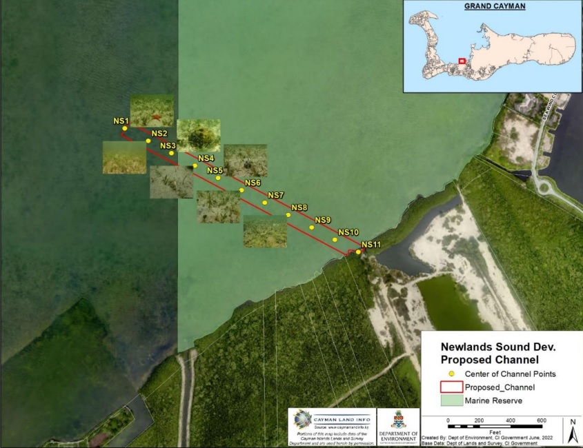
According to the recently released minutes of a 30 July Cabinet meeting, the government granted a coastal works licence to Newlands Sound Development Ltd. to dredge a 100-foot-wide and 1,626-foot-long channel to allow access to a proposed subdivision.
The subdivision, described variously as The Isles at Newlands, The Island at Newlands Sound or The Isle at Newlands, is on land owned by the Bodden family.
In its review of the coastal works application, the Department of Environment recommended that Cabinet reject the proposal, saying it will be detrimental to the marine life in the area, and noting that the National Conservation Act bans dredging in protected areas “unless specifically exempted through a permit issued under that Act”.
“Such a permit should only be issued under truly exceptional circumstances, which do not pertain to this application,” the DoE said.
Bodden has listed ‘The Isle at Newlands’ as one of her business interests in the Register of Interests for Members of Parliament.
A search of the Cayman Islands Companies Registry indicates that Bodden is a director of a company called The Island at Newlands Sound Owners Association Ltd. and of Newlands Sound Development Ltd.

However, when contacted by the Compass, Bodden said she was not involved in the project.
She said the land had been left to her family by their late father, Jay Bodden, and that her sister Harilyn was the family member involved in the development.
“It is part of my family’s heritage,” she said, adding, “I am not the developer of it.”
She referred all other questions from the Compass regarding the project to her sister. The Compass has reached out to Harilyn Bodden by phone and email but had not received a response by press time.
Cabinet decision
Decisions on planning applications on sites that are below the mean high water mark, such as The Isles at Newlands channel, are made by Cabinet, rather than the Central Planning Authority.
No details of the discussions that led to the decision in Cabinet were given in the brief minutes released by government on 9 Aug., which only noted, “Approved the issuance of a Coastal Works Permit for Block 27B, Parcel 115 to dredge an access channel”.
Block 27B, Parcel 115 is the land on which The Isles of Newlands – which involves a 143-lot, canal-front residential development – is proposed to be built.
The application noted that the channel is being proposed because the depth of the water at the shoreline of the subdivision is not deep enough for recreational boats. The work would involve dredging 67,885 cubic yards of material to a dewatering area via a 12-inch-diameter pipe.
The dredged material from the channel excavation would be used to fill the remainder of the site, which is “currently below the minimum levels prescribed by the Central Planning Authority”, according to the application.
In its review, dated 16 Sept. 2022, the DoE noted that the work would affect 3.8 acres of Crown property, and would involve removing 0.35 acres of mangroves and 3.5 acres of seagrass.
Protected marine reserve
In outlining its objections to the application, the Department of Environment pointed out that the majority of the proposed channel is located within a protected marine reserve.
“The rationale for designating Marine Reserves is to ensure that breeding and nursery areas for marine life (especially queen conch and spiny lobster) are protected. The excavation of an access channel can have an adverse impact on habitats such as seagrass beds and coastal mangroves, which support these breeding and nursery areas. The proposed work also encroaches into the Mangrove Buffer Zone,” the DoE noted.
The department also stated that since the sand and fine silt of the seagrass beds are easily disturbed, there is likely to be “detrimental sediment plumes which can impact surrounding seagrass communities and marine organisms that depend on good water quality” during the dredging work.
It argued that, despite the applicant’s assertion that silt screens would be used during dredging, from previous experience the department has observed that it is “not possible to eliminate the impacts of the sediment plumes generated during a dredging project of this scale through the use of silt screens”.
In its report to Cabinet, it showed images from two dredging projects – at Harbour House Marina and the Holiday Inn – which had been approved by a previous administration, showing “substantial sedimentation impacting the marine environment”.
The DoE noted the proposed location for the dewatering site contains three lakes and a small basin behind the mangrove buffer that is connected to the North Sound Marine Reserve, and pointed out that the applicant wants to combine the three lakes and the basin to form one large body of water.
Sedimentation concerns
It added, “The turbidity caused by the de-watering exercise could impact the Marine Protected Area and lead to the sedimentation of the lake including eutrophication, harmful algal blooms, dead zones, and fish kills.
“We are unclear at this time whether there is any wildlife other than fish living in the existing ponds. If there is, the turbidity will impact any organisms living within the ponds and there could be animal welfare concerns from the public, which is outside of the remit of the DoE.”
The department cited a 2002 CH2MHill study regarding dredging in North Sound that had concluded that there had been more than 20% loss of “unique shallow transitional habitat linking mangroves with seagrass beds along the western and southern shores of North Sound”, and that there was ample evidence that seagrasses and associated fish and invertebrate communities had not successfully recolonised areas that had been dredged, even after many years.
“Prohibiting further major dredging projects in the North Sound for aggregate and fill acquisition was thus a primary recommendation of that report. This policy and the recommendations of CH2MHill have, in the main, been adhered to by successive governments in recent years,” the DoE said.
Loss of ‘unique habitat’
It noted that while this application may not be deemed to be for a major dredging project compared to historical borrow pit dredging for aggregate, “the effects of this project should be considered as a part of a larger cumulative impact on this habitat type (and North Sound on a whole) from incremental, smaller projects proposed or approved over time and set within a degraded baseline due to previous projects.
“This proposal for a navigational channel will still augment the loss of this unique habitat by an additional 3.8 acres.”
The DoE also noted that the site is located within one of the islands’ Marine Protected Areas – sites that have been designated by Cabinet for the long-term conservation of marine resources and ecosystem services.
“MPAs, especially no-take MPAs such as Marine Reserves, are one of the most powerful and effective methods for protecting resources and ocean life – but only if activity which damages or degrades the environment is limited within them. The proposed dredging will directly and adversely impact part of the MPA and will indirectly adversely impact a much wider area within the MPA because the sedimentation and turbidity are very difficult to contain,” the DoE stated.
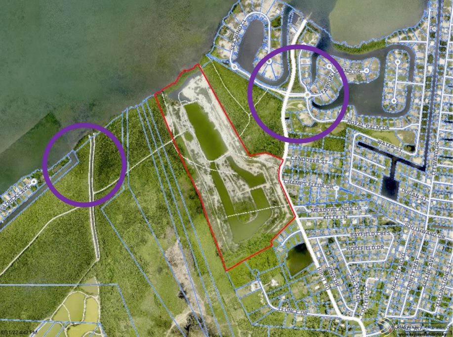
It recommended that alternatives be explored, such as marketing The Isles by Newlands as a lakeside development with ocean access for non-motorised waters sports, such as paddle boarding, kayaking, snorkelling, or small catamarans.
It also suggested that if canal access is the most desired option, the applicant could explore negotiating an easement across neighbouring parcels – an approach, the DoE said, which was used by HH Ltd, by The Ritz-Carlton canal, and which resulted in greatly reduced environmental effects.
“In this case, pursuing an easement either to the east or west to join an existing canal or dredged area would reduce the environmental impact and potentially eliminate the need for dredging within an MPA,” the department said.
The Compass has reached out to Sustainability Minister Katherine Ebanks-Wilks for more information on Cabinet’s decision and is awaiting a response.
Related Videos


Another example of the Cayman government not caring about the environment. There are hardly any big fish on the north side because of over fishing. The island brings in tens of millions of dollars a year from scuba diving and yet it does nothing to help the industry. The westside dock that lots of scuba boats use has not been fixed properly for at least 4 years. Now they are going to let more protected area be destroyed. Glad I am 75 and will not be round when no one wants to dive on Grand Cayman.
It seems we have reached a new low in allowing fill to be obtained from a “protected Marine Reserve”, if Dart had applied this would never have been approved. Has this ever been allowed before?.
Well done Cayman.
Trashing the environment again.
Keep going and it’ll soon all be gone..