
The Central Planning Authority has approved an application by its former chairman A. L. Thompson to build a $7.5 million, 311-lot subdivision among the mangrove forest, located beside a planned extension and connector road of the East-West Arterial.
The planning board granted Thompson, who was its chairman until 2021, permission to carry out phased development of the project, which the developer says he intends to use for affordable housing, with each of the three phases being conveyed before work begins on the next phase.
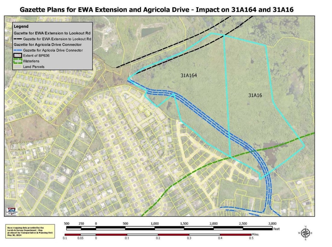
The site, on two parcels of land over 85.4 acres, is located east of the Woodland Drive subdivision in Savannah, near the Frank Hall Homes development.
The National Roads Authority is in the process of building an extension of the East-West Arterial from Hirst Road to Woodland Drive. Two further extensions of the road are planned from Woodland Drive to Lookout Garden and then onto Frank Sound, and are subject to an environmental impact assessment because of their potential impact on the Central Mangrove Wetland.
Smaller lots
According to the recently released minutes of the 28 Aug. meeting, at which the matter was considered, the planning board noted that it had granted permission because, “with the exception of the lot sizes and lot widths”, the application complies with the development and planning regulations.
Most of the lots in the low-density residential zone in question are 6,000 square feet. Planning regulations state that lots in such zones should be a minimum of 10,000 square feet.
The CPA, in outlining the reasons behind its decision to grant planning permission, said, “there is sufficient reason and exceptional circumstance to allow the lesser lot sizes and lot widths” because the site will be bounded by two major public roads, thereby making it “more suited to higher density development, which in this case, is represented by the smaller lots sizes and lot widths and the proposed future multi-family development and future commercial development”.
The two roads bounding the site are the as yet unbuilt East-West Arterial road extension and the Savannah By-Pass Connector.
The Department of Environment pointed out that Thompson’s site is predominantly on primary habitat classified as seasonally flooded mangrove forests and woodland, and that mangroves are a protected species under the National Conservation Act.
The CPA had earlier adjourned a decision on the application while it referred it to the National Conservation Council.
The DoE, responding under delegated authority from the National Conservation Council, noted that the subdivision proposal would result in small, 6,000-square-foot lots and, “if developed, would result in a high density of development and increased urbanisation of this presently wetland habitat”.
It called for a proper assessment of drainage in the low-lying area, stating that the location is prone to flooding, “and the site is likely acting as a stormwater drainage basin for the surrounding area”.
The DoE added, “The clearing and filling of this site may exacerbate flooding in the surrounding area as it will reduce the site’s natural capacity to retain stormwater. Therefore, a stormwater management plan should be provided for the area, as a part of the application, to ensure that the water potentially being displaced by the development of the land will not impact the wider area.”
The planning board, as one of the conditions it laid down when granting the application, stated that a stormwater management plan must be submitted and approved for each of the three phases of the subdivision.
“The plan shall be designed to embrace storm water runoff produced from a rainfall intensity of 2 inches per hour for one hour of duration and should include, but not be limited to, the location of all drainage facilities and general grading details of the parcels (roads included),” the board said.
“In general, the entire site shall be graded in such a manner that stormwater runoff is no more than that which occurred during predevelopment conditions along private boundaries with any excess runoff directed to one central drainage facility or a series of facilities.”
Under the conditions of approval, as advised by the Department of Environment, the developer must also ensure that there will be no land clearing, excavation, filling or development of the subdivided parcels – with the exception of the road parcel – without prior planning permission.
Low-cost housing plan
The board, in approving the project, noted that having smaller lots than allowed under the regulations was acceptable as Thompson had stated that his intention was to apply for a government-approved, low-cost housing programme. The CPA pointed out that there were other similar similar size lots in the vicinity.
It also noted, “The proposal will not be materially detrimental to persons residing or working in the vicinity, to the adjacent property, to the neighbourhood, or to the public welfare.”
Thompson told the board he intended to provide 191 affordable lots on the site, but had not yet done pricing for those lots.
The Department of Planning, in its analysis of the application, stated that during the plan review stage, it had inquired with the applicant as to the lack of evidence that the location would be used as a government-approved, low-cost housing scheme, and was told the subdivision had been “shown to the Minister but after that meeting, we decided to make the submission to Planning and let them sent it back to the Ministry”.
Objections to access road
There were a number of objections to the application, mostly from residents of The Haven, next door to the proposed site, who opposed having a through road at the location. One neighbour wrote that an access road to the development would bring “increased traffic, noise, and potential safety hazards” as well as “disrupt the peaceful and residential nature” of the neighbourhood.
Another wrote, “Our neighborhood prides itself on being a close-knit, family-oriented community, providing a safe environment where our children have the freedom to ride their bikes, skate, walk, run and play in the streets without fear of being endangered by increased volume of motorists. In addition to our children’s safety, our community members utilize the roads for various recreational activities, including walking, running, and other forms of exercise. Introducing a through road would not only disrupt this cherished aspect of our neighborhood but also pose significant safety risks to our residents.”
The planning department noted that the site has 30-feet-wide vehicular access on two neighbhouring parcels of land, which would provide access to about 50 of the lots within the subdivision. The remaining lots would gain access from the future connector road and extension of the East-West Arterial, which the NRA has stated will be constructed in fall 2024.
Noting that the road extension is subject to an EIA, the department said, “The Authority may wish to determine if the subdivision application should be held in abeyance until the final location of the E-W by-pass has been determined.”
Responding to objections about road access, Thompson, when he appeared before the planning board, said those would be short lived because when the East-West Arterial is extended, no one living in the new subdivision will use the access roads through the neighbouring property as they’ll use the connector road or the East-West Arterial bypass instead.
He added that once the National Roads Authority constructs the roads, then he would block off the road access through their subdivision.
He said he had owned the land before the affordable housing in the neighbouring Frank Hall Homes were developed, and that Frank Hall Homes had given him three access points through that site.
He added that his own company has 25 to 30 staff members looking for homes.
According to the minutes, he argued that the main ingredient in affordable housing is land – the larger the lot, the more expensive it is. He noted that a modest three-bedroom house can be built on a 6,000-square-foot lot, claiming that Frank Hall Homes with 10,000-square-foot lots “created slums and people adding onto them illegally”.
The minutes indicate board members pointed out to Thompson that the CPA was in the midst of a National Development Plan review and “effectively, this application is asking the CPA to make a policy decision to effectively rezone the land”.
The board asked Thompson “what are the exceptional circumstances to ask the CPA to make a policy decision to effectively rezone the land when a Development Plan review is being done”.
The minutes say Thompson replied that this was not a rezone and that the CPA had the discretion to allow the smaller lots.
“He has waited 20 years to develop this land and now they are saying he has to wait another 20 years for a new Development Plan,” the minutes recorded.
Fred Whittaker of Whittaker & Watler Architects, which is the architectural company working on the project, noted that government low-cost housing allows for smaller lots of 6,000 square feet, and that if the private sector was also allowed to do so, it would take pressure off the government to provide affordable housing.
Thompson said he did not intend to sell off the land lots, but planned to build homes on them and sell them, similar to how Frank Hall Homes operates.
Related Videos


I hope if approved all of these developers incorporate a better drainage system as we all know now deep wells do not work and is also contributing to the now flooding we are currently experiencing.
“The clearing and filling of this site may exacerbate flooding in the surrounding area as it will reduce the site’s natural capacity to retain storm water. ” Indeed. After the island being shut down for three days for flooding when a tropical storm passed and didn’t even hit, and with more disruption and flooding now anticipated. But I guess the we don’t learn from experience when it comes to balancing the profits of development against the environmental impact that affects everyone.
More mangroves going to be destroyed. So much for protection of the land
Presumably this land became much more valuable once the location of the East West arterial was finalised.