
As Grand Cayman’s population continues to increase, the island’s traffic problems are unlikely to go away.
Data from the National Roads Authority spells out the reality of Cayman’s current concerns, some of the reasons for it and the extent to which it could still get worse.
The Compass looks at seven key graphics that illustrate the issue.
1. People don’t live where they work
While the blue dots on the map of Grand Cayman that shows where people live are fairly evenly distributed, the red dots that show where people work are clustered almost exclusively around George Town and Seven Mile Beach.
Almost half of Cayman’s voting population lives east of Grand Harbour and the vast majority of those travel through this critical choke point to get to work or go to school every day.
The NRA believes construction of the new East-West Arterial Highway will help shift more meaningful jobs to the eastern districts, but it is not clear how this will happen without a direct policy plan or incentive. Equally Plan Cayman, the upgrade to the Development Plan, could incentivise office development in the east or help create mixed-use communities where people can live, work and go to school within the same zone.
2. Get ready for the two-hour commute
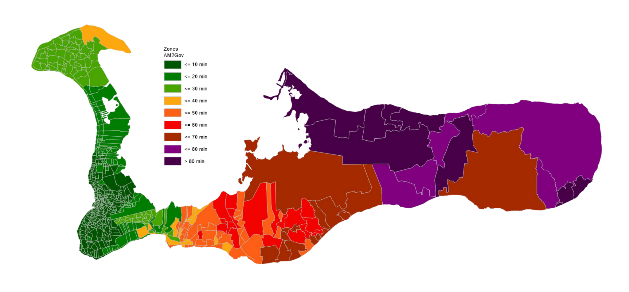
Heat map data from the NRA shows a blot of purple spreading like a bruise across the eastern districts. This is the NRA’s map of how traffic will look in 2026 without an enhanced highway infrastructure, including a 10-mile extension to the East-West Arterial highway.
The purple illustrates journey times of 80 minutes or longer at peak times.
The NRA data suggests that building the road would eliminate those purple zones — at least initially – bringing journey times from North Side and East End into George Town down to less than an hour.
The map also illustrates what the authority has described as a socio-economic imbalance, with the bulk of the western side of the island coloured green, demonstrating shorter journey times.
3. How journeys will increase by 2026
The NRA has crunched the numbers to illustrate how journey times could increase by 2026, when it anticipates there will be 80,000 people in Cayman, an increase of 8,000 from current estimates, with a proportionate increase in vehicles.
Without new road building, the NRA data suggests, everyone’s commute will get longer. The graph shows how much they could increase against current journey times.
4. Four-lane network from Frank Sound to West Bay
The NRA’s goal is to create a ‘primary network’ of four-lane highways running from Frank Sound to West Bay.
The East-West Arterial expansion and road-widening projects on parts of Bobby Thompson Way will help achieve that.
The purple line on the map shows multi-lane capacity. Use the slider button to see where the NRA is building or plans to build new lanes to finish the network.
5. More people, more cars, more traffic
One of the more self-explanatory data points from the NRA’s research is the correlation between population growth and traffic.
As the number of people in Cayman has risen, so has the number of registered vehicles on the road.
The graph shows the link between the two.
6. Rush hour is already pushing 3 hours
Traffic volume data pinpoints the stretch of Shamrock Road opposite Burger King, between 7am and 8am, as the place and time you might least want to be on the roads in Cayman.
At that point – based on 2018 data analysed by the NRA – more than 2,000 vehicles per hour were crawling towards the Grand Harbour roundabout.
It’s only marginally better an hour before or an hour later, with traffic only really beginning to calm down after 9am.
Further east, the pattern is similar, though some intersections, for example, by Domino’s Pizza on Shamrock Road – see their highest volumes of traffic between 6am and 7am and a slight, gradual improvement thereafter.
This is not a good sign, however. The NRA attributes this to the fact that the road has reached its capacity and traffic is moving more slowly because of jams further upstream.
7. Two possible futures
The NRA data modelling shows commute times from North Side could double in little over a decade.
Forecasting an increase in cars on the road, linked to population growth, planners examined what journey times could look like in 2026 and 2036, compared to baseline data from 2018.
One scenario factored in the East-West Arterial Expansion and the widening of roads around George Town. The other examined the ‘do nothing’ approach.
Estimating that Cayman’s population could hit 80,000 by 2026 and reach 100,000 by 2036 – in line with recent growth trends – they found the average morning journey time from Old Man Bay to key destinations in George Town and beyond would take twice as long. If the full suite of highway infrastructure improvements is introduced, journey times won’t get quicker. In fact, the NRA data shows they will still increase, just by much smaller margins.
Interactive graphics: Stephanie Ditta
Related stories: Beyond the Highway
Related Videos


